US Location-based Services Market Size and Share
Market Overview
| Study Period | 2020 - 2031 |
|---|---|
| Forecast Data Period | 2026 - 2031 |
| Base Year Market Size (2025) | USD 23.82 Billion |
| Market Size (2026) | USD 27.33 Billion |
| Market Size (2031) | USD 54.32 Billion |
| Growth Rate (2026 - 2031) | 14.72 % |
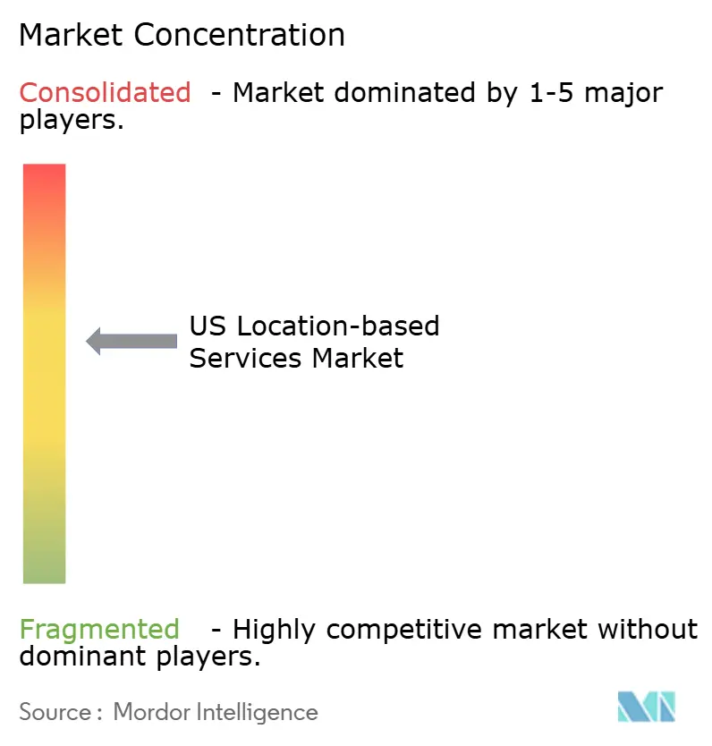
| Market Concentration | Medium |
Major Players *Disclaimer: Major Players sorted in no particular order Image © Mordor Intelligence. Reuse requires attribution under CC BY 4.0. | |
US Location-based Services Market Analysis by Mordor Intelligence
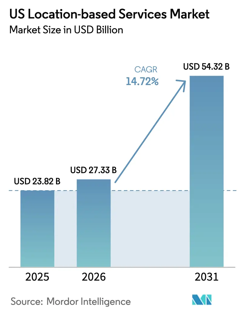
US location-based services market size in 2026 is estimated at USD 27.33 billion, growing from 2025 value of USD 23.82 billion with 2031 projections showing USD 54.32 billion, growing at 14.72% CAGR over 2026-2031. The growth trajectory is fueled by 5G maturation that now covers more than 300 million Americans, a smartphone penetration rate expected to reach 91% of mobile connections by 2028, and widening enterprise demand for real-time operational visibility in logistics, healthcare, and retail settings[1]Ericsson, “5G in the North America Region – Ericsson Mobility Report,” ericsson.com. Federal Transit Administration (FTA) programs that standardize General Transit Feed Specification (GTFS) datasets are widening use cases beyond turn-by-turn navigation into multimodal journey planning and transit analytics. Simultaneously, generative-AI platforms such as CARTO GenAI and Oracle Spatial AI are lowering the skills barrier for spatial analytics by supporting natural-language queries of geospatial data. However, compliance costs linked to California’s Location Privacy Act (AB 1355) and emerging state-level data sovereignty bills are forcing providers to invest in privacy-by-design architectures and flexible consent-management workflows.
Key Report Takeaways
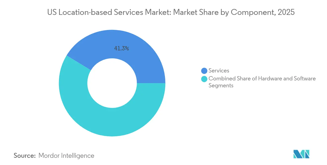
- By component, services led with 41.32% revenue share in 2025 while professional and managed services are projected to advance at a 17.12% CAGR through 2031.
- By location type, outdoor positioning held 55.47% of the US location-based services market share in 2025, whereas indoor positioning is set to expand at a 20.46% CAGR.
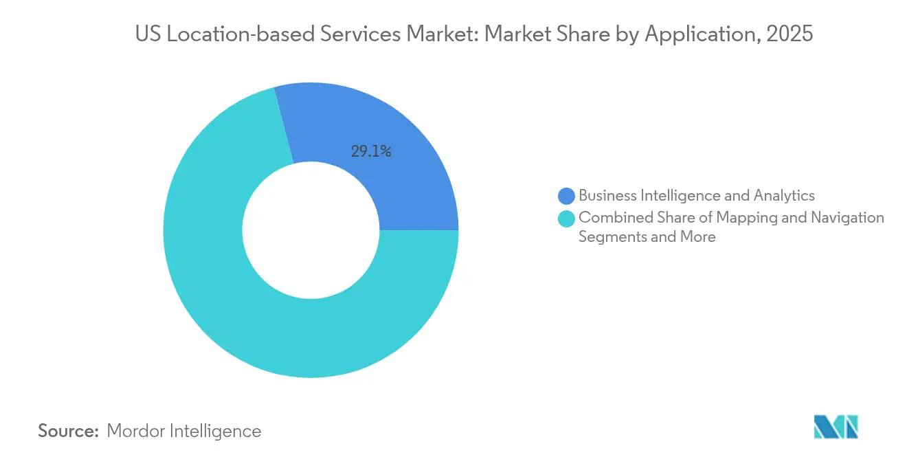
- By application, business intelligence and analytics captured 29.05% share of the US location-based services market size in 2025, while location-based advertising is forecast to grow at a 23.62% CAGR.
- By end-user vertical, transportation and logistics accounted for 23.68% of 2025 revenues, yet healthcare is expected to post the fastest 18.93% CAGR through 2031.
Note: Market size and forecast figures in this report are generated using Mordor Intelligence’s proprietary estimation framework, updated with the latest available data and insights as of 2026.
National developments in United states connect differently with activity unfolding across other parts of the world. In the global location based services market coverage, Mordor Intelligence integrates these into a single analytical framework.
US Location-based Services Market Trends and Insights
Drivers Impact Analysis*
| Driver | (~) % Impact on CAGR Forecast | Geographic Relevance | Impact Timeline |
|---|---|---|---|
| Smartphone penetration and 5G rollout | +2.3% | National, major metropolitan areas | Medium term (2-4 years) |
| Geo-marketing spend surge | +1.8% | National, retail-dense regions | Short term (≤ 2 years) |
| Demand for real-time asset visibility (RTLS) | +1.5% | Healthcare and manufacturing hubs | Medium term (2-4 years) |
| Growth of indoor mapping for retail and venues | +1.2% | Urban centers and high-traffic venues | Medium term (2-4 years) |
| Federal transit LBS datasets unlocking new use cases | +0.9% | Transit-heavy metropolitan areas | Long term (≥ 4 years) |
| Generative-AI-powered spatial analytics | +0.8% | Tech-forward enterprise clusters | Long term (≥ 4 years) |
| Source: Mordor Intelligence | |||
Smartphone penetration and 5G rollout
Wide-area 5G now provides low-band coverage to more than 300 million Americans and supports sub-meter positioning when paired with advanced multilateration algorithms. Qualcomm’s X85 5G Modem-RF integrates an on-chip AI engine that enhances time-of-arrival calculations for location accuracy inside large venues. Fixed-wireless access (FWA) rollouts to 9 million premises show 5G’s potential beyond mobility, opening opportunities for geofencing-based home automation and rural asset tracking. Carriers now package “premium positioning” subscriptions; surveys indicate 35% of 5G users will pay extra for enhanced indoor navigation in airports and arenas. These monetization signals underpin long-run revenue confidence for providers in the US location-based services market.
Geo-marketing spend surge
Retailers are pivoting budgets toward proximity-driven campaigns because real-time offers lift in-store conversion rates above demographic-only targeting benchmarks. Cisco Meraki cameras now fuse anonymized WiFi probing with computer vision to segment shoppers by visit frequency and dwell time, feeding that data into dynamic ad platforms. Forty-seven percent of mobile consumers opt in to receive store-triggered coupons when within 100 meters, according to Cisco’s 2025 retail analytics survey. AI-powered demand forecasts allow marketers to pre-buy inventory programmatically when foot-traffic spikes are predicted, converting location data from a descriptive to a predictive asset. The outcome is double-digit budget reallocation to location-targeted formats that accelerates revenue for the US location-based services market.
Demand for real-time asset visibility (RTLS)
Mission Hospital’s CenTrak deployment curbed annual equipment shrinkage by USD 150,000 and generated USD 200,000 in efficiency gains, validating ROI for healthcare RTLS. Sonitor’s SonitorONE supports six locating modalities in one stack and uses 50% fewer beacons than prior-generation systems, reducing installation disruption. Manufacturers leverage EVS mobe3 Live over existing WiFi to track work-in-process goods without extra cabling. These case studies prove that RTLS converts reactive searches into predictive maintenance cycles, a benefit that is pulling new verticals such as food processing into the US location-based services market.
Growth of indoor mapping for retail and venues
Mall of America’s deployment of Inpixon’s interactive maps raised average visitor session time by 13% and supplies anonymized heatmaps for leasing analytics. Hyper AR’s computer-vision toolkit reaches sub-meter accuracy across 200,000 square-feet without external anchors, letting grocers re-sequence pick paths and save USD 2–3 per online order. Apple Indoor Maps’ standardized venue-map schema eases onboarding into enterprise systems such as mobe3 Live, slashing project timelines. The resulting data flow underpins unified commerce dashboards where retailers see both e-commerce and in-store journeys, driving new software subscriptions within the US location-based services market.
Restraints Impact Analysis*
| Restraint | (~) % Impact on CAGR Forecast | Geographic Relevance | Impact Timeline |
|---|---|---|---|
| High installation and maintenance cost | –1.2% | National, rural and small markets | Short term (≤ 2 years) |
| Privacy and data-protection compliance burden | –0.8% | CA, MA, IL with national spillover | Medium term (2-4 years) |
| Indoor RF interference in legacy buildings | –0.6% | Dense urban cores | Medium term (2-4 years) |
| State-level data-sovereignty legislation | –0.4% | State-by-state | Long term (≥ 4 years) |
| Source: Mordor Intelligence | |||
High installation and maintenance cost
Predictive WiFi surveys start at USD 395 but full on-site validation climbs to USD 1,450, and end-to-end enterprise deployments average USD 2,000 for every 10,000 square-feet before hardware [2]SecurEdge Networks, “How Much Does a WiFi Site Survey Cost?” securedgenetworks.com. Fiber backhauls adds as much as USD 33,900 for 300-meter digs and takes three to four months to permit and trench. Healthcare installations must pass electromagnetic compatibility tests, raising commissioning budgets and elongate timelines. While Bluetooth low-energy and ultra-wideband can ride existing Ethernet, organizations still face software licensing, security patching, and analytics-platform subscriptions across the life cycle. These cumulative costs stall adoption among mid-tier retailers and community hospitals, tempering near-term growth in the US location-based services market.
Privacy and data-protection compliance burden
California AB 1355 obliges opt-in consent for any collection of “precise geolocation,” a definition that encompasses GPS, IP addresses, and triangulated WiFi identifiers. Enterprises must therefore embed consent orchestration, granular data-retention rules, and subject-access dashboards. Massachusetts and Illinois are drafting parallel frameworks that diverge on allowable processing purposes, creating multi-state governance complexity. Providers now earmark 6–8 % of project budgets for compliance audits, legal reviews, and continuous monitoring. As smaller players lack dedicated privacy teams, they often limit deployments to jurisdictions with clearer rules, clipping addressable revenue within the US location-based services market.
*Our forecasts treat driver/restraint impacts as directional, not additive. The impact forecasts reflect baseline growth, mix effects, and variable interactions.
Segment Analysis
By Component: Services Deliver Integration Expertise
Services own 41.32% of 2025 revenues and are forecast to record a 17.12% CAGR because enterprises require end-to-end delivery from RF survey through analytics dashboard. Managed services bundles now incorporate location-based data-quality SLAs, proactive sensor-battery replacement, and quarterly analytics tuning. Simultaneously, hardware demand remains steady for IoT tags, beacons, and multi-band antennas that underpin physical capture layers, while software licenses scale in line with sensor counts and data-analytics workloads. CenTrak’s turnkey deployments illustrate why hospitals choose outsourced integration to align RTLS with electronic medical records and nurse-call systems without over-loading internal IT teams . Qualcomm’s Aware enterprise platform further blurs the line between hardware and services by offering device-agnostic APIs that still necessitate solution architects for optimal edge-to-cloud configuration.
In contrast, self-build strategies inside retail and manufacturing operations increasingly combine open-source mapping SDKs with off-the-shelf WiFi analytics, but hidden maintenance overhead often negates up-front savings. As a result, the services segment continues to capture the highest margin profile in the US location-based services market.



By Location Type: Indoor Positioning Breaks Out
Outdoor GPS solutions retained 55.47% revenue share in 2025 thanks to the entrenched role of navigation and last-mile delivery in e-commerce logistics. Yet indoor positioning is projected to grow at a 20.46% CAGR as hospitals, airports, and big-box retailers chase sub-meter accuracy for staff workflows and shopper engagement. Silicon Labs’ BG22 Bluetooth System-on-Chip enables low-power asset tags that report through dense RF environments typical of medical facilities. Apple’s standardized Indoor Maps data model is speeding venue adoption by removing bespoke map-creation steps. This combination of chipset innovation and ecosystem standardization is enlarging the indoor slice of the US location-based services market.
Legacy structures still suffer multipath interference from metallic fixtures, so solution providers deploy AI-assisted calibration routines that auto-tune beacon placement. These advances shrink commissioning windows from weeks to days, helping indoor deployments gain parity with mature outdoor services and setting the stage for future indoor–outdoor handoff use cases that will dominate the US location-based services industry.
By Application: Analytics Tops Navigation
Business intelligence and analytics applications controlled 29.05% of 2025 market value, overtaking navigation for the first time. CARTO’s GenAI makes spatial analysis conversational, letting non-technical staff ask, “Which zip codes saw in-store sales lift after last week’s billboard campaign?” and receive map-based answers in seconds. Oracle Spatial AI adds anomaly detection for events such as crime hot spots and disease clusters, moving analytics from descriptive toward prescriptive practice. Location-based advertising remains the fastest-growing use case at a 23.62% CAGR, driven by programmatic exchanges that sell bid requests with geofencing metadata packaged for real-time bidding.
Consumer mapping and navigation continue to enjoy broad smartphone adoption, yet revenue per user has plateaued as basic turn-by-turn grows commodity. Therefore, software vendors pivot to multimodal routing that fuses transit data unlocked by the FTA, adding subscription-ready premium features such as carbon-tracking dashboards. The analytics focus is expected to widen the US location-based services market size where data-monetization potential outstrips legacy license fees.
By End-user Vertical: Healthcare Takes the Growth Crown
Transportation and logistics remain the biggest spender with 23.68% share, leveraging geofencing for driver compliance and dynamic route recalculation when congestion arises. However, healthcare will log a 18.93% CAGR as RTLS moves from pilot to system-wide deployments that support infection-control workflows and asset-life-cycle optimization. CenTrak’s latest installation yielded a one-year payback, prompting hospital boards to earmark capital budgets for broader coverage. Manufacturing, hospitality, and BFSI sectors follow close behind by tapping location insights to enhance safety audits, guest navigation, and fraud analytics.
In parallel, government agencies modernize transit operations through open data mandates, while IT-telecom players integrate location APIs into IoT platforms to anchor edge-AI applications. This multi-vertical uptake solidifies a diversified demand base that cushions the US location-based services market against sector-specific downturns.
Geography Analysis
Tier-one metropolitan corridors—New York, Los Angeles, San Francisco, and Chicago—account for more than half of enterprise deployments because they combine dense 5G coverage with technology-savvy workforces eager to exploit real-time visibility. The Northeast concentrates academic medical centers that pilot RTLS for patient throughput, while Silicon Valley hosts start-ups building AI-driven geospatial analytics platforms that later scale nationally. West Coast retailers lead indoor-mapping adoption, underpinned by robust venture funding and early consumer acceptance of app-mediated store experiences. The US location-based services market continues to grow fastest in Sunbelt states such as Texas and Florida where manufacturing and logistics hubs prioritize supply-chain precision to offset labor shortages.
California’s AB 1355 privacy regime effectively sets the default for nationwide compliance checklists, compelling vendors in other states to conform even before local laws take effect. In contrast, rural counties face higher per-square-foot installation costs and intermittent 5G coverage, elongating return-on-investment horizons. Carriers are mitigating this divide through fixed-wireless access that extends low-band 5G to 9 million rural homes, thereby unlocking new addressable pockets for the US location-based services market. Federal Transit LBS pilots in Minneapolis and Seattle further anchor opportunities in mid-tier metros by promoting open data ecosystems that private developers can monetize.
Looking forward, state-level data-sovereignty bills in Massachusetts and Illinois could introduce region-locked storage mandates. Vendors planning national rollouts now architect geo-fenced data lakes to adapt without wholesale re-platforming, a design choice that adds upfront cost but preserves scale economics across the broader US location-based services industry.
Mordor Intelligence's coverage of the location based services market extends across other regions including Middle East and Africa, while country-specific intelligence is also available for Canada, Brazil, United Arab Emirates, Nigeria, China, Japan, and India, each offering a view on the jurisdiction-level dynamics as applicable.
Regulatory Landscape
US location-based services (LBS) regulation is shaped by public-safety and privacy rules that affect how location is collected, routed, and retained. The Federal Communications Commission (FCC) requires location-based routing for wireless 911 voice calls on IP-based networks, and 47 CFR 9.10(s) established nationwide obligations that became active in November 2024, pushing carriers and LBS enablers to operationalize more precise civic location handling for NG911 pathways.
On privacy, Section 222 of the Communications Act governs customer proprietary network information and reinforces consent and safeguarding obligations for providers handling location derived from network data. Industry and standards bodies also influence compliance-by-design: CTIA publishes LBS best-practices and guidelines, while NENA specifications such as the Civic Location Data Exchange Format for the United States (CLDXF-US) standardize civic location data elements used in NG911 systems, shaping how LBS platforms normalize addresses and location attributes across applications.
Value Chain Analysis
The US LBS value chain starts with hardware and connectivity layers (GNSS modules, radios, tags and beacons) and network operators (CMRS carriers) that provide the radio access and signaling used for outdoor and hybrid positioning. Platform providers sit on top of this layer, supplying basemaps, geocoding, routing, and spatial analytics, along with developer APIs. Solution providers and system integrators then design, deploy, and operate end-to-end offerings (including RF surveys, indoor map creation, device management, and analytics dashboards) for enterprises across transportation and logistics, healthcare, retail, and government.
Data and interoperability layers increasingly shape time-to-deploy and the range of use cases that can be supported. USDOT's National Address Database (NAD) functions as a foundational address dataset used across federal stakeholders, improving address accuracy for civic and commercial workflows, while NENA and broader standards ecosystems (including bodies such as 3GPP and ITU) support interoperability for location exchange in public-safety contexts. Across the chain, application and platform owners remain responsible for implementing user notice and consent mechanisms for location collection and use, which in turn increases demand for privacy-by-design architectures, consent-management tooling, and auditable data-retention controls.
Competitive Landscape
The competitive field remains moderately fragmented: platform leaders Google and Apple dominate consumer navigation, yet specialized providers such as CenTrak, Zebra Technologies, and Inpixon command healthcare and indoor-analytics niches. Microsoft extends Azure Maps through alliances with TomTom, HERE, and Esri, offering developers unified APIs that bundle routing, gridded weather, and pedestrian heatmaps. Qualcomm’s chipset roadmap, targeting USD 22 billion in automotive and IoT revenue by FY29, underscores how silicon differentiation influences accuracy and power consumption—key buying criteria for enterprise RTLS.
Strategically, incumbents hedge against privacy risk by embedding on-device processing that reduces raw-location data egress, as evidenced by Apple’s Private Relay and Google’s Federated Analytics. Consolidation also shapes the market: Platform Science’s acquisition of Trimble’s fleet-telematics division merges hardware, ELD compliance software, and data-monetization services into one stack. Meanwhile, HERE Technologies introduced an AI-powered guidance assistant for software-defined vehicles, signaling intensifying RandD competition around in-vehicle location intelligence.
Niche disruptors gain ground through ultra-wideband micro-location and AI-first mapping engines, but scaling remains capital intensive. Overall, the top five vendors control roughly 45–50% of segment revenues, giving the US location-based services market a market-concentration score of 6, denoting a balanced but tightening competitive environment.
US Location-based Services Industry Leaders
IBM Corporation
Cisco Systems Inc.
Google LLC
HPE Aruba Inc
Zebra Technologies Corporation
- *Disclaimer: Major Players sorted in no particular order

Market Opportunities and Future Outlook
Public-safety modernization creates a durable whitespace for vendors that can productize civic-grade location, particularly where indoor and vertical positioning accuracy remains a pain point. FCC workstreams on improving vertical location accuracy, including Height Above Ground Level reporting and floor-level estimation discussions, increase the value of solutions that fuse WiFi, Bluetooth, ultra-wideband, and network-derived signals into standardized civic location outputs that NG911 systems can ingest.
Open and standardized addressing datasets also expand downstream application opportunities beyond navigation. The USDOT National Address Database (NAD) initiative, guided by its September 2025 Action Plan to advance nationwide coverage of address points validated by 911 for open use, supports higher-quality geocoding, dispatch, and service-eligibility workflows for both government and enterprises. In parallel, 2026 federal activity around NG911 interoperability certification, referenced in a Second Further Notice of Proposed Rulemaking, points to opportunities for platform providers and integrators that can align ESInet and NGCS interoperability requirements with scalable location data exchange and governance capabilities.
Recent Industry Developments
- March 2026: Cisco Spaces released updates including hierarchical license management for IoT services at the campus and building level. It also enabled TLS 1.3 support for the Location Network Mobility Services Protocol.
- July 2024: Esri and IBM announced the commercial availability of ArcGIS Enterprise on Kubernetes integrated with IBM Maximo Application Suite for spatial analytics and asset management. The integration strengthens enterprise spatial analytics and asset lifecycle workflows by combining location intelligence with asset data.
- April 2024: HPE Aruba Networking launched Wi-Fi 7 access points with ultra tri-band hardware technology featuring integrated location-based services supporting 802.11az for self-location networks. A GNSS receiver enables floor-level mapping to enhance indoor positioning accuracy.


Research Methodology Framework and Report Scope
Market Definition and Coverage
This market is defined as revenue generated in the United States from services and software that use a device or asset location to deliver functions like mapping, navigation, tracking, and location-triggered customer engagement across consumer and enterprise use cases.
Scope exclusions: We exclude hardware-only location devices and one-time mapping projects that do not involve an ongoing location-enabled service component.
Segmentation Overview
- By Component
- Hardware
- Software
- Services
- By Location Type
- Indoor
- Outdoor
- By Application
- Mapping and Navigation
- Business Intelligence and Analytics
- Location-based Advertising
- Social Networking and Entertainment
- Other Applications
- By End-user Vertical
- Transportation and Logistics
- IT and Telecom
- Healthcare
- Government
- BFSI
- Hospitality
- Manufacturing
- Other End-users
Data Sources, Market Sizing, and Validation
Desk Research
Desk research was used to set the boundary of what counts as a location-enabled service and to build the initial demand and supply indicators that we can then check independently. Public sources such as the US Census Bureau (business and household indicators), Bureau of Economic Analysis (digital economy and services trends), Bureau of Labor Statistics (industry employment and wage signals), Federal Communications Commission (wireless and connectivity statistics), and USPTO patent publications (location, mapping, and positioning filings) helped anchor the market context in measurable series.
We also reviewed US public company filings, earnings call transcripts, investor presentations, and trusted press coverage to understand product direction, pricing motion, and customer adoption narratives. When a company split was not clear in public documents, we used paid subscriptions for company financials and intelligence, plus a paid patent database for cross-checking technology activity and ownership. These desk sources are not exhaustive, and many other public documents and data tables were used to collect, validate, and clarify the final assumptions.
Primary Interviews and Surveys
Primary work focused on confirming what share of revenue is truly location-driven versus adjacent digital services, and on validating price and usage assumptions that cannot be reliably inferred from headlines alone. We spoke with a mix of solution owners, channel and integration partners, and buyer-side practitioners across major US end users, which helped refine adoption rates, typical contract structures, and replacement cycles used in the model.
Distribution of primary research fieldwork respondents
| Company type | Respondent position |
|---|---|
| Top tier: 29% | CXOs: 18% |
| Mid tier: 50% | Functional/Unit leaders: 26% |
| Smaller Players: 21% | Managers: 56% |
Market-Sizing & Forecasting
The core sizing logic uses a top-down build where US digital services spend and mobility and navigation demand indicators are reconstructed into a location-enabled revenue pool, then filtered through adoption and usage intensity. To keep the output realistic, we corroborate with selective bottom-up checks, such as sampled vendor revenue exposure to location features, channel feedback on deal sizes, and a simple price times volume sanity check for common use cases.
Key inputs included smartphone and connected-device penetration, app-based navigation and mapping usage intensity, enterprise adoption of asset and fleet tracking, advertising spend trends tied to location targeting, and the mix shift between subscription and usage-based pricing. Where bottom-up signals were patchy, such as private company revenue splits, we handled the gap using ranges from interviews and then narrowed them with US customer cohort logic. For forecasting, we ran scenarios, aligning adoption and pricing trajectories to what practitioners expected for privacy rules, consent rates, and AI-enabled location features over the next cycle.
Data Validation & Update Cycle
Model outputs were validated through triangulation across independent demand signals and supply-side disclosures, then reviewed for internal consistency before sign-off. When large variances appeared, we rechecked the inputs and re-contacted relevant experts to confirm whether a real market shift was occurring or whether a data artifact was driving the swing.
We refresh the report annually, with interim updates when a material event affects pricing, regulation, or major end-market demand. Before delivery, an analyst performs a fresh pass on the latest disclosures and public indicators so clients receive the most current view available at the time of publication.
Mordor Intelligence's United States Location Based Services Market Size Compared Against Other Published Estimates
Published market values for US location-based services can vary, even when the topic name looks the same, because the counted revenue pool is not always defined in the same way and the timing of price and currency assumptions can shift the total. Differences also come from how teams treat privacy-driven demand changes, and whether they validate the model with buyer-side checks or rely mainly on supplier narratives.
A refresh-led gap is common here because ASPs can change quickly as pricing moves toward bundles, consumption billing, or freemium-to-paid conversion, and small timing choices can compound across a large user base. By re-testing pricing logic and adoption inputs close to publication (instead of locking them earlier in the cycle), and then reconciling them with independent usage and spend signals, the final number is kept tighter, a step applied by Mordor Intelligence.
Benchmark comparison
| Source | Market Size | Gaps in Research Methodology |
|---|---|---|
| Mordor Intelligence | USD 23.82 B (2025) | |
| Trade Journal A | USD 30.30 B (2024) | Uses an earlier-year base and carries forward a fixed pricing curve, which can overstate revenue when more usage shifts into bundles and discounted tiers. |
| Industry Publisher B | USD 37.22 B (2025) | Appears to include broader adjacent location intelligence and RTLS-type revenues and applies a more aggressive adoption ramp without clear buyer-side validation checks. |
The table shows that timing and scope choices can explain most of the spread, especially when the market is moving fast on pricing and packaging. A repeatable model that ties revenue to clear US usage drivers, and then checks those assumptions through interviews and secondary signals, helps keep the estimate transparent and easier to reconcile over time.


Key Questions Answered in the Report
What is the current value of the US location-based services market?
The market is valued at USD 27.33 billion in 2026 and is projected to grow to USD 54.32 billion by 2031.
Which component segment is growing fastest?
Services are expanding at a 17.12% CAGR because enterprises prefer managed deployments that handle integration complexity end-to-end.
Why is indoor positioning gaining momentum over outdoor GPS?
Breakthroughs in Bluetooth low-energy, ultra-wideband, and standardized indoor maps now deliver sub-meter accuracy, enabling new retail and healthcare workflows that outdoor GPS cannot support.
How are privacy regulations affecting the market?
California’s AB 1355 and emerging state bills require explicit opt-in consent and granular data-retention controls, driving up compliance costs and influencing solution design nationwide.
Page last updated on:


 Your data is secure and never sold or shared.