
Seismic Survey Market Size and Share
Market Overview
| Study Period | 2022 - 2032 |
|---|---|
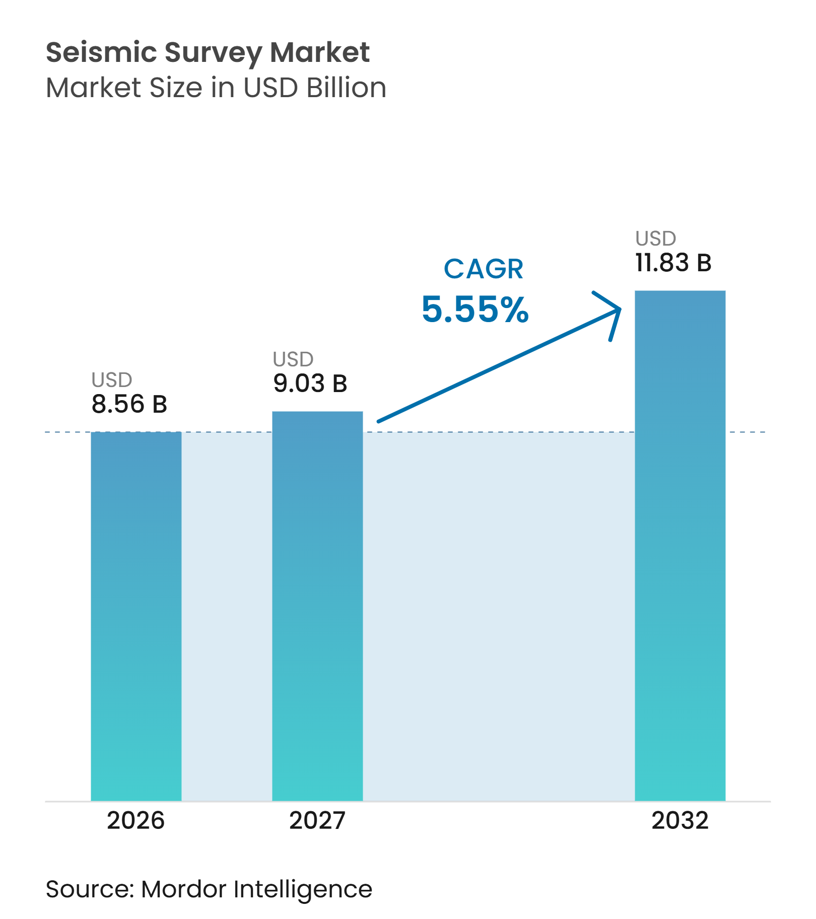
| Market Size (2027) | USD 9.03 Billion |
| Market Size (2032) | USD 11.83 Billion |
| Growth Rate (2027 - 2032) | 5.55 % |
| Fastest Growing Market | Asia-Pacific |
| Largest Market | North America |
| Market Concentration | Medium |
Major Players *Disclaimer: Major Players sorted in no particular order Image © Mordor Intelligence. Reuse requires attribution under CC BY 4.0. | |
Seismic Survey Market Analysis by Mordor Intelligence
The global seismic survey market size is projected to expand from USD 8.56 billion in 2026 to USD 11.83 billion by 2032, registering a CAGR of 5.55% between 2027 and 2032. Reserve replacement needs continue to support seismic spending even when operators remain selective with discretionary exploration budgets. The global seismic survey market is shifting from a vessel-led acquisition business toward a broader mix of imaging, interpretation, and data licensing services. This shift raises the value delivered by each survey and reduces reliance on raw fleet utilization alone. Offshore licensing, repeat reservoir monitoring, and carbon storage compliance create recurring work across several basins. Contractors that combine acquisition capability with proprietary data and processing tools are better placed to manage uneven project funding.
Key Report Takeaways
- By technology, 3D seismic imaging held 41.3% of the global seismic survey market share in 2026, while 4D or time-lapse seismic is forecast to grow at a 7.1% CAGR through 2032.
- By deployment location, onshore surveys held 69.8% of the global seismic survey market share in 2026, while offshore surveys are forecast to grow at a 7.3% CAGR through 2032.
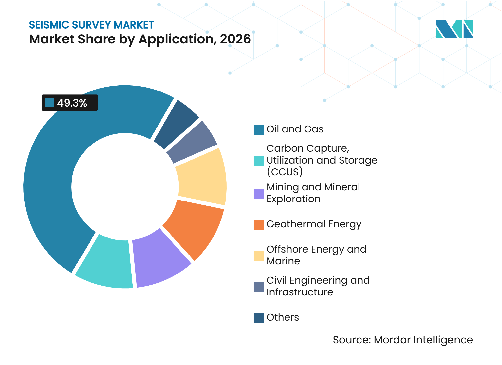
- By application, oil and gas held 49.3% of the global seismic survey market share in 2026, while carbon capture, utilization, and storage is forecast to grow at a 15.4% CAGR through 2032.
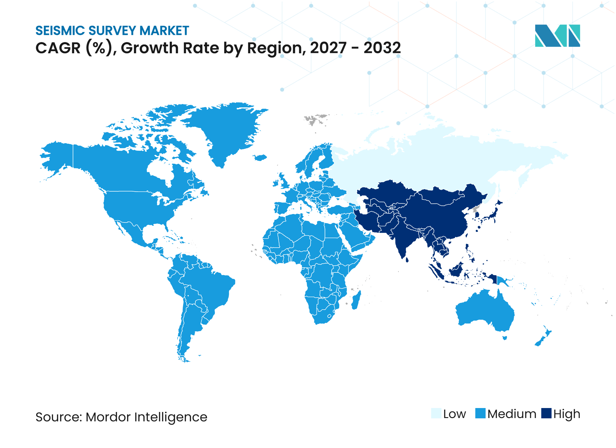
- By geography, North America held 35.9% of the global seismic survey market share in 2026, while Asia-Pacific is forecast to grow at a 6.8% CAGR through 2032.
Note: Market numbers in this report are based on Mordor Intelligence's proprietary estimation framework, which combines nine months of actuals with Q4 projections for base year 2026.
Market Trends and Insights
Drivers Impact Analysis of Seismic Survey Market*
| Driver | (~) % Impact on CAGR Forecast | Geographic Relevance | Impact Timeline |
|---|---|---|---|
| Offshore Licensing and NOC Deepwater Campaigns | +1.3% | Global, concentrated in Asia-Pacific, Middle East and Africa, and South America | Medium term (2-4 years) |
| 4D Reservoir Monitoring and Production Optimization | +0.9% | North Sea, Gulf of America, Brazil, and Middle East and Africa | Medium term (2-4 years) |
| CCUS Monitoring and Verification Requirements | +1.1% | North America, Europe, and Australia | Long term (≥ 4 years) |
| AI-Enabled Processing and Legacy Data Monetization | +0.8% | Global | Short term (≤ 2 years) |
| High-Resolution Imaging for Complex Subsurface Geology | +0.6% | Global, intensified in deepwater and tight formations | Medium term (2-4 years) |
| Non-Hydrocarbon Demand from Geothermal, Mining and Infrastructure | +0.5% | Europe, APAC, South America | Long term (≥ 4 years) |
| Source: Mordor Intelligence | |||
Offshore Licensing and NOC Deepwater Campaigns
Offshore licensing activity is extending acquisition backlogs across several basins. Norway awarded 57 production licenses to 19 companies in the APA 2025 round, and Aker BP received 22 licenses, including 12 as operator. The Norwegian Ministry of Energy also announced APA 2025 in May 2025, supporting continued activity on the Norwegian Continental Shelf[1]. These awards support demand for seismic work because license holders need better subsurface information before selecting prospects and planning wells. National oil companies add another source of demand because their programs often cover multiple fields or acreage blocks. Shearwater reported a USD 413 million backlog in the third quarter of 2025, showing that contractor order books can benefit when several offshore programs move forward together.
4D Reservoir Monitoring and Production Optimization
Time-lapse seismic supports production decisions at established fields rather than only frontier exploration. TGS reported that production work represented 40% of its towed-streamer contract activity from 2020 through 2024, while 4D work represented 95% of its ocean-bottom-node contract work over the same period. This use case can make the global seismic survey market less exposed to short-term changes in exploration budgets. Operators use repeat surveys to observe reservoir movement, identify bypassed hydrocarbons, and assess compaction in complex fields. PXGEO states that its MNode system has a 300-day battery life and can operate in water depths of 3,000 meters, which supports longer monitoring campaigns. The same repeat-survey model is also relevant for storage sites that need evidence of carbon dioxide containment.
CCUS Monitoring and Verification Requirements
Carbon storage projects create demand for both baseline and repeat seismic measurements. SLB identifies measurement, monitoring, and verification plans as a core part of carbon storage project development. Active 3D surveys, repeat 4D surveys, and passive monitoring can serve different stages of a storage project. Dawson Geophysical lists carbon capture sequestration projects among its client categories in its 2025 Form 10-K. STRYDE supplied 42,000 nodes for the CarbonCuts onshore carbon dioxide storage survey in Denmark[2]. This work adds a compliance-led revenue stream that sits alongside conventional exploration and production activity.
AI-Enabled Processing and Legacy Data Monetization
AI tools are shortening processing cycles and making older seismic libraries more useful. BGP reported work on a 10-billion-parameter 3D AI model based on the Kunlun large model, with pilot testing planned for the end of 2025. Better imaging can improve the value of acquired data without adding vessels or land crews. Viridien continues to position advanced imaging and data services as part of its portfolio, including its seismic reimaging program over Angola’s Block 22. This model creates service revenue from reprocessing and data licensing even when new acquisition programs slow. It also gives national oil companies a way to extract more value from accumulated subsurface archives.
Restraints Impact Analysis of Seismic Survey Market*
| Restraint | (~) % Impact on CAGR Forecast | Geographic Relevance | Impact Timeline |
|---|---|---|---|
| Cyclical E&P Capital Allocation and Multi-Client Funding Volatility | -1.2% | Global, most acute in independent E&P markets | Medium term (2-4 years) |
| Marine-Mammal Permitting and Survey Downtime | -0.5% | Gulf of America, North Sea, Mediterranean, and Australia | Medium term (2-4 years) |
| High Fixed Costs and Aging Marine Acquisition Fleets | -0.6% | Global offshore contractors | Medium to Long term |
| Specialist Geophysicist and Processing Talent Shortages | -0.4% | Global, most acute in North America and Europe | Long term (≥ 4 years) |
| Source: Mordor Intelligence | |||
Cyclical E&P Capital Allocation Creates Funding Gaps in Multi-Client Programs
The multi-client model depends on customers committing funding before contractors acquire and license a data set. This makes pre-funding vulnerable when operators reduce discretionary exploration spending. Shearwater described a cautious customer environment and a flattish marine seismic market in its third-quarter 2025 results. TGS sold the Ramform Explorer and Ramform Valiant after the integration of PGS, reflecting the cost pressure associated with fleet ownership. A delayed acquisition season can also reduce later licensing opportunities because the data library receives fewer new surveys. This effect can leave a gap between a recovery in upstream spending and a recovery in seismic revenue.
Marine-Mammal Permitting Adds Scheduling Risk to Offshore Survey Programs
Offshore survey schedules are shaped by local rules on underwater sound and protected species. NOAA issued an authorization for geophysical survey activity in the Gulf of America that was effective from September 2025 through April 2026. NOAA’s final monitoring report for a Gulf of America OBN survey recorded 30 mitigation actions over nine months, including 19 delays and 4 source shutdowns[3]. The JNCC’s draft 2025 geophysical guidelines show that the United Kingdom is also updating how projects assess environmental effects[4]. These requirements can increase planning time and limit the periods when vessels can operate. Contractors therefore need strong permitting processes and flexible vessel scheduling to protect project margins.
*Our forecasts treat driver/restraint impacts as directional, not additive. The impact forecasts reflect baseline growth, mix effects, and variable interactions.
Seismic Survey Market Segment Analysis
By Technology:
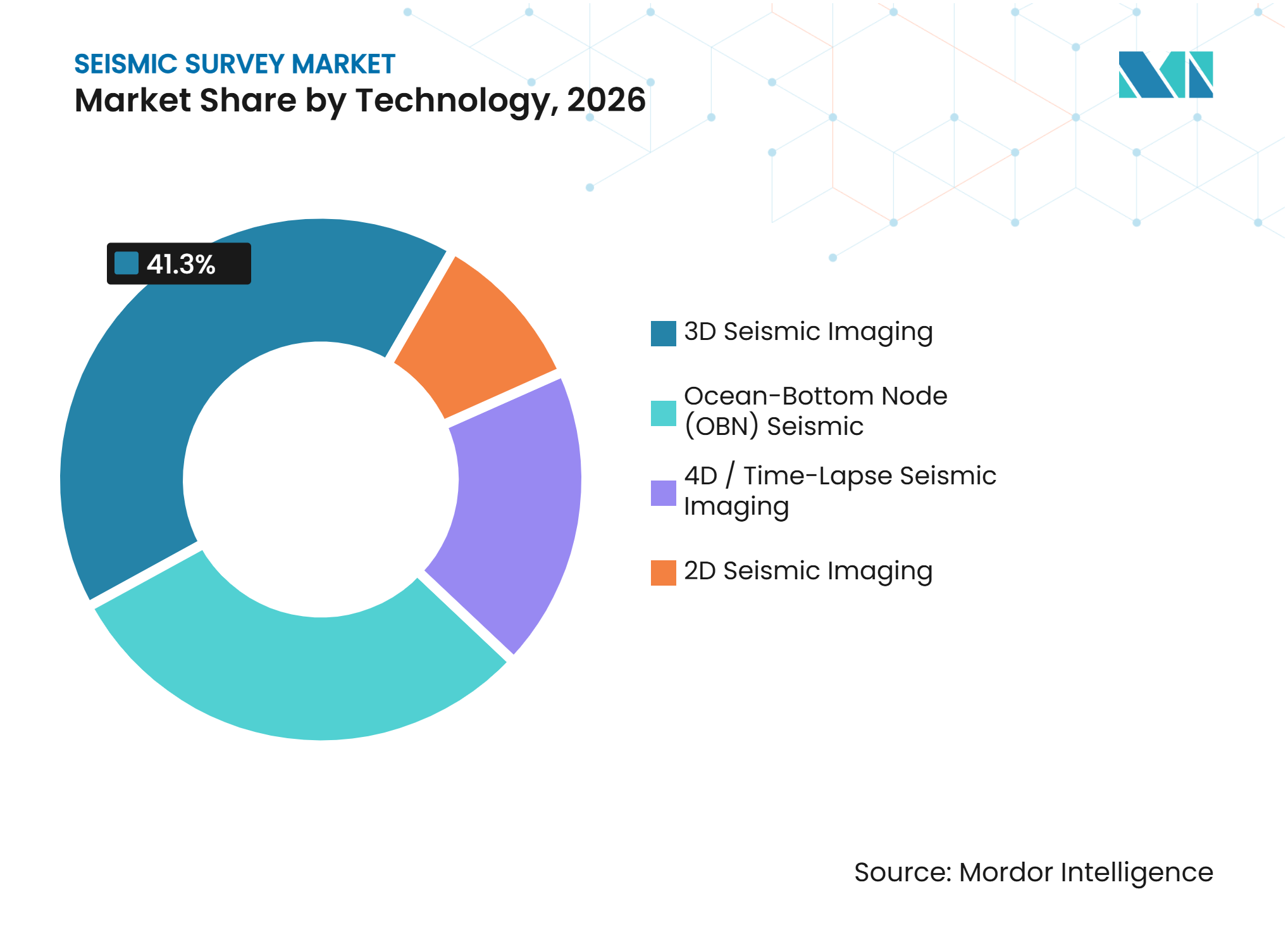
3D Seismic Imaging Supports Core Exploration and Production Work3D seismic imaging held 41.3% of the global seismic survey market share in 2026. Its scale reflects its broad use in exploration, appraisal, development planning, and reservoir management. BGP stated that seismic exploration has supported the discovery of more than 95% of global oil and gas reserves. High-density and wide-azimuth programs improve subsurface coverage in more complex areas. The large data volumes created by these programs support demand for faster processing and interpretation. The global seismic survey market size for 3D work also benefits from its role as the baseline survey for later monitoring campaigns.
2D seismic imaging remains useful for early basin mapping and shallow-water surveys. COSL reported that its 2D acquisition fell 63.8% to 7,226 kilometers in 2025, while its 3D acquisition totaled 15,722 square kilometers. Ocean-bottom-node seismic is gaining importance where complex subsalt geology, dense field infrastructure, or repeat monitoring requires better illumination. COSL reported that its OBN acquisition volume grew 63.3% to 1,769 square kilometers in 2025. PXGEO’s MNode system is designed for deepwater OBN work and long-duration deployments. 4D or time-lapse seismic is forecast to grow at a 7.1% CAGR through 2032 because operators need repeated reservoir and storage-site measurements.


By Deployment Location:
Onshore Surveys Provide the Broadest Activity BaseOnshore surveys held 69.8% of the global seismic survey market share in 2026. Land crews serve conventional oil and gas activity as well as geothermal, carbon storage, mining, and infrastructure applications. Their broad reach and lower capital intensity compared with marine vessel operations help sustain the segment. STRYDE delivered 375,000 nodes in 2025, including 2 deployments that each exceeded 100,000 channels. Sercel also received an ONGC order for 24,000 channels of 528 seismic acquisition systems in India. These deployments show the move toward larger and more flexible nodal layouts on land.
Offshore surveys are forecast to grow at a 7.3% CAGR through 2032. The higher growth rate reflects deepwater licensing, production monitoring, and the increasing use of OBN systems in mature fields. Shearwater began a third season of acquisition in Brazil’s Pelotas Basin in November 2025. It also received a contract for Ghana’s first deepwater OBN survey in the Jubilee and TEN fields. The U.S. Department of the Interior extended prospecting permit durations from 3 years to 5 years in 2025 U.S. Longer permits can improve planning certainty for offshore programs.
By Application:
Oil and Gas Remains the Largest Source of DemandOil and gas held 49.3% of the global seismic survey market share in 2026. The segment spans frontier exploration, appraisal, reservoir monitoring, and production optimization. The American Association of Petroleum Geologists reported that pressure to replace reserves continued to support confidence in the geophysical sector during 2025. Repeat 4D work shifts more spending toward producing fields and can make demand more recurring. This is particularly relevant in mature offshore assets where small improvements in reservoir understanding can influence development decisions. The global seismic survey market remains linked to oil and gas investment, but its exposure is broader than new exploration alone.
Carbon capture, utilization, and storage is forecast to grow at a 15.4% CAGR through 2032. Storage projects require evidence that injected carbon dioxide remains contained, making seismic a relevant part of monitoring plans. STRYDE’s CarbonCuts deployment in Denmark illustrates the use of dense node systems for an onshore storage project. Geothermal energy also uses similar subsurface methods. Vulcan Energy began 2D seismic work for a geothermal heat project with BASF in Germany in 2025 and planned a follow-on 3D survey. Mining and civil engineering broaden the set of non-hydrocarbon applications for seismic methods.

Geography Analysis
North America
North America held 35.9% of the global seismic survey market share in 2026. Demand comes from Gulf of America offshore programs, established onshore basins, and a growing set of carbon storage projects. TGS and Viridien launched Laconia Phase III in the Gulf of America in June 2025, covering approximately 151 Outer Continental Shelf blocks. The work combines OBN acquisition, source technology, and advanced imaging, which shows how offshore projects increasingly depend on integrated services. Pulse Seismic reported USD 35.86 million (CAD 51.1 million) in 2025 revenue, compared with USD 16.42 million (CAD 23.4 million) in 2024, driven by seismic library sales and demand tied to energy transition applications in Western Canada. U.S. environmental oversight also remains important, with NOAA authorizations setting operational conditions for offshore surveys
Asia-Pacific
Asia-Pacific is forecast to grow at a 6.8% CAGR through 2032, giving the region the fastest growth rate among the geographic segments. National oil company programs and new basin activity support this pace. COSL completed a 3D seismic survey in Indonesia’s Gorontalo Basin in December 2025. PXGEO received its first Malaysia contract in August 2025 under a 2-year agreement with a minimum 365-day commitment. Asian Energy Services also reported a USD 5.83 million (INR 54.63 crore) contract for 4D seismic acquisition and processing at the Bhaskar Field in Gujarat during December 2025. China approved GB 12950-2025, a seismic exploration explosion safety standard that takes effect in November 2026
Europe, South America, and Middle East and Africa
Europe is supported by Norwegian licensing and the expansion of carbon storage activity. The Norwegian Ministry of Energy announced APA 2025, which keeps the Norwegian Continental Shelf active for future exploration planning. South America has gained momentum through Brazil’s Pelotas, Santos, and Campos basins, where contractors are pursuing multi-client and OBN work. Shearwater’s third Pelotas season provides a visible example of sustained acquisition in the basin. In the Middle East and Africa, large national oil company programs continue to support contractor utilization. INOVA supplied 220,000 Quantum nodes and 30 Titan vibrator vehicles for a project involving BGP and ADNOC in the United Arab Emirates. Egypt’s advanced seismic program with SLB and Viridien also shows that technology-led data programs are expanding beyond established North American and European centers.
Competitive Landscape
Market Concentration
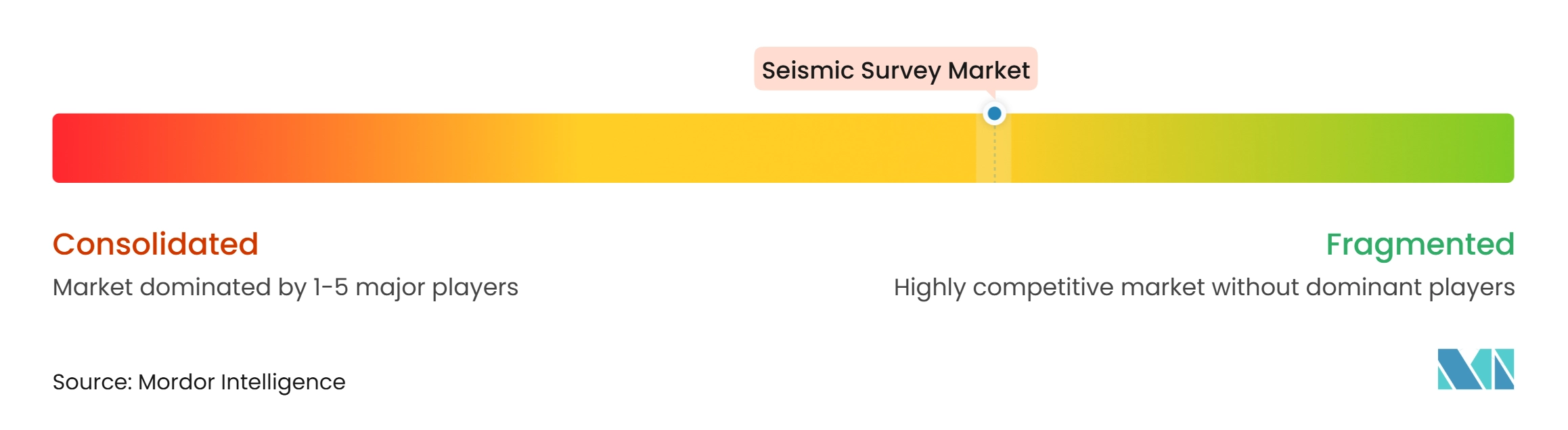
The global seismic survey market is moderately concentrated. BGP, TGS, Shearwater GeoServices, COSL, and Viridien are active across offshore acquisition, imaging, and data services. BGP stated that it had ranked first by annual operating revenue in global geophysical services for 20 consecutive years and had led the OBN marine segment for 4 consecutive years. TGS completed the PGS integration in July 2024, bringing multi-client data, vessel operations, OBN capability, and imaging services into one platform. COSL’s 63.3% rise in OBN acquisition volume in 2025 shows the value of fleet and technology investment in premium offshore work.
Company strategy is centered on lowering deployment cost, improving imaging quality, and expanding data libraries. Aker BP partnered with PXGEO to use autonomous underwater vehicles for OBN deployment. Viridien introduced Sercel Accel in June 2025 as an onshore drop-node system that does not need nodes to be planted. TGS sold its North American well data products business to Enverus in July 2026 for USD 100 million in cash and a USD 15 million earn-out, reinforcing its focus on other energy data activities. These moves show that competitive advantage increasingly depends on technology and data assets, not only vessel numbers. Equipment firms such as STRYDE, INOVA, Geospace Technologies, and Sercel remain important because nodal systems set the economics of many land and offshore projects.
The global seismic survey market also includes specialized data-library and processing firms that serve local or application-specific needs. Pulse Seismic operates a licensable Canadian seismic library and reported strong 2025 revenue growth. SAExploration strengthened its operational footprint by acquiring inApril AS in January 2025 and Terrex Seismic in September 2025. Shearwater, PXGEO, and SeaBird continue to pursue offshore opportunities where basin access and specialist capability matter. The industry therefore combines a few large global platforms with focused contractors and equipment suppliers. Data quality, regulatory readiness, and the ability to repeat monitoring surveys remain key points of differentiation.
Seismic Survey Industry Leaders
-
TGS ASA
-
BGP Inc. (China National Petroleum Corporation)
-
Viridien
-
Shearwater GeoServices Holding AS
-
China Oilfield Services Limited (COSL)
- *Disclaimer: Major Players sorted in no particular order
Seismic Survey Market Companies Covered in this Report
- Asian Energy Services Limited
- BGP Inc. (China National Petroleum Corporation)
- China Oilfield Services Limited (COSL)
- Dawson Geophysical Company
- Fugro N.V.
- Geospace Technologies Corporation
- Halliburton Company
- INOVA Geophysical
- ION Geophysical Corporation
- MIND Technology, Inc.
- Pulse Seismic Inc.
- PXGEO
- SAExploration Holdings, Inc.
- SeaBird Exploration PLC
- Sercel
- Shearwater GeoServices Holding AS
- SLB
- STRYDE Ltd.
- TGS ASA
- Viridien (formerly CGG)
Recent Industry Developments in Seismic Survey Market
- July 2026: TGS completed the sale of its North American well data products business to Enverus for USD 100 million in cash plus a USD 15 million earn-out, reflecting TGS’s strategic focus following the PGS integration
- September 2025: SAExploration acquired Terrex Seismic, strengthening its presence in the Australian land seismic business.
- August 2025: Shearwater GeoServices received a contract for Ghana’s first deepwater OBN seismic survey in the Jubilee and TEN fields.
- June 2025: TGS and Viridien launched the Laconia Phase III OBN survey in the Gulf of America, covering approximately 151 Outer Continental Shelf blocks.
Global Seismic Survey Market Report Scope
A seismic survey is a geophysical exploration technique used to investigate the geological structure and composition of the Earth's subsurface by generating and recording seismic waves. These waves travel through underground rock formations and are reflected or refracted at boundaries between different geological layers. The recorded signals are processed and interpreted to create images of subsurface structures, helping identify potential oil and natural gas reservoirs, mineral deposits, underground geological formations, and suitable locations for infrastructure development.
The global seismic survey market is segmented by technology, deployment location, application, and geography. By technology, the market is segmented into 2D seismic imaging, 3D seismic imaging, 4D/time-lapse seismic imaging, and ocean-bottom node (OBN) seismic. By deployment location, the market is segmented into onshore seismic surveys and offshore seismic surveys. By application, the market is segmented into oil and gas, offshore energy and marine, carbon capture, utilization and storage (CCUS), mining and mineral exploration, geothermal energy, civil engineering and infrastructure, and others. The report also covers the market size and forecasts for the global seismic survey market across 26 countries in key regions. For each segment, the market sizing and forecasts are provided on the basis of value (USD).
Segmentation Overview
| 2D Seismic Imaging |
| 3D Seismic Imaging |
| 4D / Time-Lapse Seismic Imaging |
| Ocean-Bottom Node (OBN) Seismic |
| Onshore Seismic Surveys |
| Offshore Seismic Surveys |
| Oil and Gas |
| Offshore Energy and Marine |
| Carbon Capture, Utilization and Storage (CCUS) |
| Mining and Mineral Exploration |
| Geothermal Energy |
| Civil Engineering and Infrastructure |
| Others (Natural Hazard Assessment, Environmental Studies, and Academic & Research) |
| North America | United States |
| Canada | |
| Mexico | |
| Europe | Germany |
| France | |
| Italy | |
| Spain | |
| United Kingdom | |
| Netherlands | |
| Norway | |
| Russia | |
| Rest of Europe | |
| Asia-Pacific | China |
| India | |
| Japan | |
| Australia | |
| Indonesia | |
| Malaysia | |
| Thailand | |
| Rest of Asia-Pacific | |
| South America | Brazil |
| Argentina | |
| Colombia | |
| Rest of South America | |
| Middle East and Africa | Saudi Arabia |
| United Arab Emirates | |
| Egypt | |
| Oman | |
| Nigeria | |
| Rest of Middle East and Africa |
| By Technology | 2D Seismic Imaging | |
| 3D Seismic Imaging | ||
| 4D / Time-Lapse Seismic Imaging | ||
| Ocean-Bottom Node (OBN) Seismic | ||
| By Deployment Location | Onshore Seismic Surveys | |
| Offshore Seismic Surveys | ||
| By Application | Oil and Gas | |
| Offshore Energy and Marine | ||
| Carbon Capture, Utilization and Storage (CCUS) | ||
| Mining and Mineral Exploration | ||
| Geothermal Energy | ||
| Civil Engineering and Infrastructure | ||
| Others (Natural Hazard Assessment, Environmental Studies, and Academic & Research) | ||
| By Geography | North America | United States |
| Canada | ||
| Mexico | ||
| Europe | Germany | |
| France | ||
| Italy | ||
| Spain | ||
| United Kingdom | ||
| Netherlands | ||
| Norway | ||
| Russia | ||
| Rest of Europe | ||
| Asia-Pacific | China | |
| India | ||
| Japan | ||
| Australia | ||
| Indonesia | ||
| Malaysia | ||
| Thailand | ||
| Rest of Asia-Pacific | ||
| South America | Brazil | |
| Argentina | ||
| Colombia | ||
| Rest of South America | ||
| Middle East and Africa | Saudi Arabia | |
| United Arab Emirates | ||
| Egypt | ||
| Oman | ||
| Nigeria | ||
| Rest of Middle East and Africa | ||
Key Questions Answered in the Report
How large is the seismic survey market?
The seismic survey market size is USD 9.03 billion in 2027 and is forecast to reach USD 11.83 billion by 2032 at a 5.55% CAGR.
Which technology has the largest position in seismic surveys?
3D seismic imaging held 41.3% share in 2026 because it supports exploration, appraisal, development, and production workflows.
Why are ocean-bottom nodes gaining adoption?
OBN systems improve imaging in complex offshore settings and support repeat monitoring, especially for producing fields and carbon storage sites.
Which application is growing the fastest?
Carbon capture, utilization, and storage is forecast to grow at a 15.4% CAGR through 2032 because monitoring is integral to storage project development.
Which region is expanding fastest?
Asia-Pacific is forecast to grow at a 6.8% CAGR through 2032, supported by national oil company programs and activity in Indonesia, Malaysia, India, and China.
What limits offshore seismic activity?
Operator funding cycles and marine-mammal permitting requirements can delay projects and increase operating costs.