Satellite-Based Industrial Asset Monitoring Market Size and Share
Market Overview
| Study Period | 2020 - 2031 |
|---|---|
| Market Size (2026) | USD 4.08 Billion |
| Market Size (2031) | USD 7.77 Billion |
| Growth Rate (2026 - 2031) | 13.75 % |
| Fastest Growing Market | Asia-Pacific |
| Largest Market | North America |
| Market Concentration | Medium |
Major Players *Disclaimer: Major Players sorted in no particular order Image © Mordor Intelligence. Reuse requires attribution under CC BY 4.0. | |
Satellite-Based Industrial Asset Monitoring Market Analysis by Mordor Intelligence
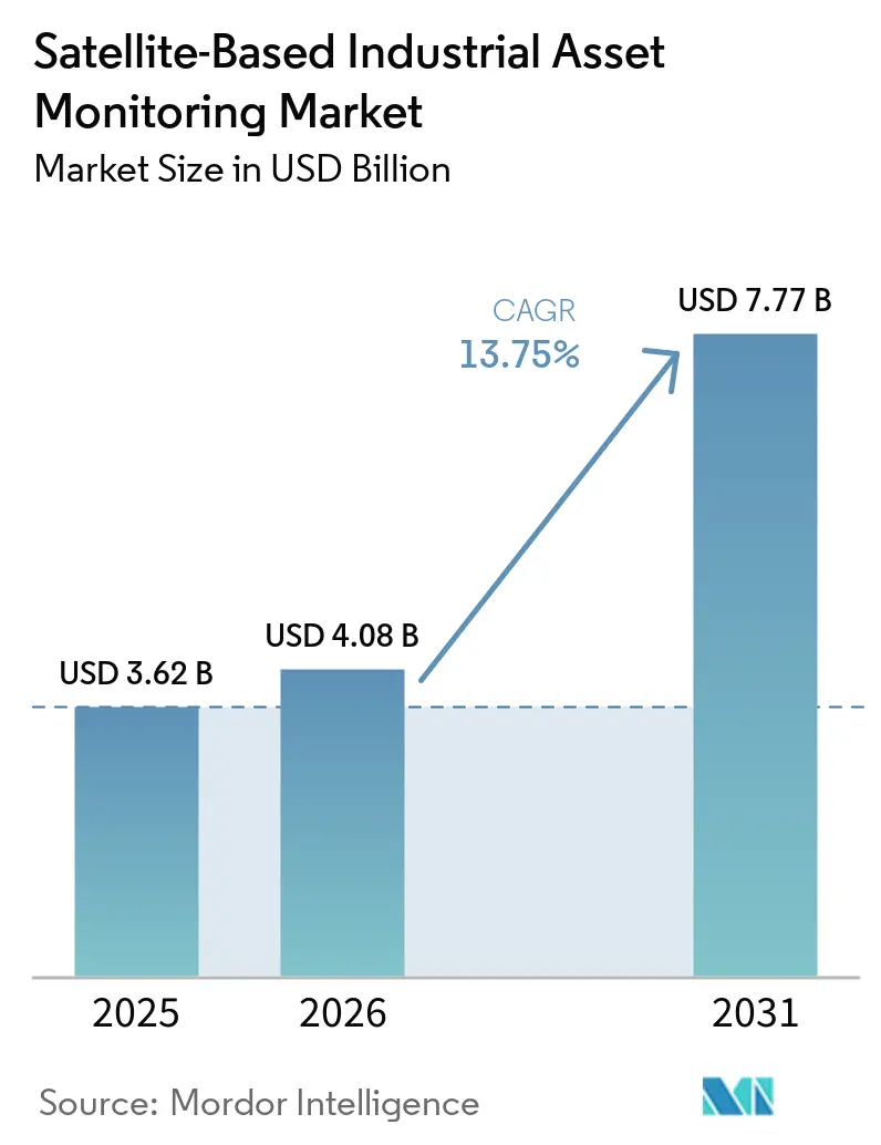
The satellite-based industrial asset monitoring market size was valued at USD 4.08 billion in 2026 and estimated to expand from USD 4.08 billion in 2026 to reach USD 7.77 billion by 2031, at a CAGR of 13.75% during the forecast period (2026-2031). Demand is rising where oil and gas, mining, utilities, and infrastructure operators cannot depend on terrestrial networks. Connectivity is increasingly specified during project design, which can make monitoring equipment part of capital spending rather than a later operating expense. The satellite-based industrial asset monitoring market is also moving toward software that places remote sensor readings within maintenance and production workflows. Regulations on pipeline patrol, methane management, and infrastructure records are making continuous observation more relevant to procurement decisions. Competition is centered on lower device power use, broader network options, and easier integration with existing operating systems.
Key Report Takeaways
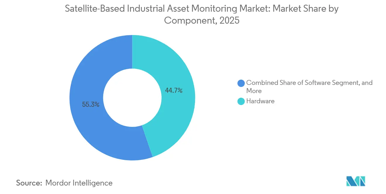
- By component, hardware accounted for 44.73% of revenue of the satellite-based industrial asset monitoring market in 2025, while software is projected to expand at a 13.94% CAGR through 2031.
- By connectivity type, LEO held 47.31% revenue share in 2025, while multi-orbit connectivity is projected to expand at a 14.21% CAGR through 2031.
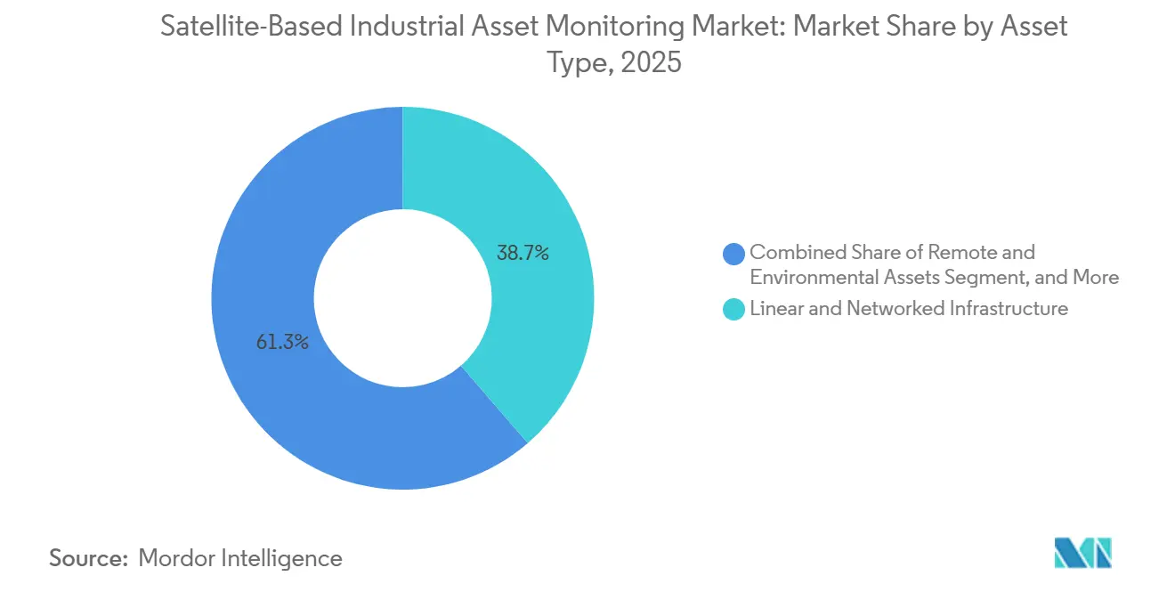
- By asset type, linear and networked infrastructure accounted for 38.67% of revenue of the satellite-based industrial asset monitoring market in 2025, while remote and environmental assets are projected to expand at a 14.16% CAGR through 2031.
- By end-user industry, oil and gas accounted for 25.83% of the satellite-based industrial asset monitoring market's revenue in 2025, while mining and metals are projected to expand at a 14.27% CAGR through 2031.
- By geography, North America held 34.71% revenue share in 2025, while Asia-Pacific is projected to expand at a 14.33% CAGR through 2031.
Note: Market size and forecast figures in this report are generated using Mordor Intelligence’s proprietary estimation framework, updated with the latest available data and insights as of January 2026.
Global Satellite-Based Industrial Asset Monitoring Market Trends and Insights
Drivers Impact Analysis*
| Driver | (~) % Impact on CAGR Forecast | Geographic Relevance | Impact Timeline |
|---|---|---|---|
| Expansion of Industrial Operations Beyond Terrestrial Network Coverage | +3.0% | Global, concentrated in Middle East and Africa, South America, and Asia-Pacific remote extraction corridors | Long term (≥ 4 years) |
| Proliferation of Low-Power Satellite IoT Devices | +2.5% | Global | Medium term (2-4 years) |
| Adoption of Predictive Maintenance for Remote and Critical Assets | +2.1% | Global, with early concentration in North America and Europe | Medium term (2-4 years) |
| Regulatory Demand for Continuous Infrastructure and Emissions Monitoring | +1.8% | North America and Europe, with spillover to Middle East and Africa and Asia-Pacific | Short term (≤ 2 years) |
| Integration of Satellite Connectivity with 3GPP Non-Terrestrial Networks | +1.4% | Global | Medium term (2-4 years) |
| Satellite-Derived Intelligence for Reducing Field Inspection Costs | +1.1% | Global, concentrated in North America and Asia-Pacific remote operations | Long term (≥ 4 years) |
| Source: Mordor Intelligence | |||
Expansion of Industrial Operations Beyond Terrestrial Network Coverage
Greenfield LNG projects in northern Mozambique and Papua New Guinea, deep-water drilling in the South Atlantic, and pipeline corridors in Central Asia can require communications beyond terrestrial coverage. These locations often lack the cellular repeater networks required for conventional monitoring, yet their equipment must still send operational and safety information to centralized teams. Projects are being designed with satellite connectivity as a primary layer from the start, rather than as a retrofit after construction. This approach places monitoring hardware within capital expenditure rather than in separate operational technology budgets, which can shorten internal approval steps. Operators can establish common equipment standards for future upgrades at nearby brownfield sites by using ruggedized LEO IoT terminals that tolerate up to 15 minutes of latency in exchange for broad coverage without per-site cellular repeaters. The satellite-based industrial asset monitoring market can benefit as remote projects move from individual deployments to standardized monitoring architectures.
Proliferation of Low-Power Satellite IoT Devices
Hardware support for 3GPP non-terrestrial network standards is reducing energy use per transmitted data point. This makes satellite links more competitive with terrestrial low-power wide-area networks across a device lifecycle, especially when operators need 1 device to function both inside and outside cellular coverage. Nordic Semiconductor, Sateliot, and Gatehouse Satcom validated a 3GPP NB-NTN connection through a LEO constellation using the nRF9151 modem in October 2025. Myriota introduced AssetHawk in February 2026, combining cellular routing where available with HyperPulse 5G NTN satellite connectivity under 1 service arrangement.[1]Myriota, “Oilfield Monitoring: EDGE and Myriota's Satellite IoT Solution,” Myriota, myriota.com. The design reduces the need for separate proprietary satellite stacks and can simplify purchasing, provisioning, and integration for equipment makers. Lower module costs may allow operators to equip full fleets rather than reserve satellite devices for isolated units.
Adoption of Predictive Maintenance for Remote and Critical Assets
Permanent satellite connectivity can have strong value where unplanned downtime or inspection work is expensive. Offshore platforms, subsea pipelines, remote wellheads, and high-voltage transformers in distant grid corridors fit this operating profile because field visits may require specialized transport and advance planning. EDGE Instruments used Myriota direct-to-orbit modules for wellhead monitoring across Argentina, Colombia, Brazil, and Bolivia, and operators reported a 40% reduction in response times after earlier anomaly detection. HiberHilo monitoring at Shell remote wells identified unexpected pressure at inactive wells and supported planned wellbore interventions.[2]Hiber Global, “How Hiber and Shell Are Transforming Remote Well Monitoring,” Hiber Global, hiber.global. These uses extend monitoring to conditions that were previously too costly to inspect frequently, allowing teams to prioritize visits based on reported conditions. The satellite-based industrial asset monitoring market gains additional demand when remote telemetry becomes part of asset health management rather than a basic location service.
Regulatory Demand for Continuous Infrastructure and Emissions Monitoring
Regulatory programs are giving satellite monitoring a more formal role in operational compliance. The EU Methane Regulation has been in effect since August 2024 and recognizes satellite monitoring as a Tier 3 verification method for measurement-based leak detection and repair.[3]European Commission, “Methane Emissions,” European Commission, energy.ec.europa.eu. From 2027, fossil gas importers must demonstrate methane intensity below 0.2% across relevant supply chains, extending monitoring to upstream producers serving Europe. PHMSA's April 2026 rulemaking formally authorized the use of satellite imagery for pipeline right-of-way patrols, giving pipeline operators a recognized option for surveillance activities. The IEA recorded more than 5 million tonnes of methane from very large oil and gas emission events detected by satellites during 2025. These requirements support more regular data collection, recordkeeping, and review across regulated assets.
Restraints Impact Analysis*
| Restraint | (~) % Impact on CAGR Forecast | Geographic Relevance | Impact Timeline |
|---|---|---|---|
| High Total Cost of Ownership for Ruggedized Satellite Monitoring Deployments | -1.5% | Global, most acute in South America, Africa, and emerging Asia-Pacific markets | Medium term (2-4 years) |
| Limited Power Budgets and Data Throughput at Remote Industrial Sites | -1.2% | Global, most acute in remote extraction and environmental monitoring sites | Medium term (2-4 years) |
| Fragmented Integration with SCADA, CMMS, ERP, and GIS Systems | -0.9% | Global, particularly in mature industrial markets in North America and Europe | Short term (≤ 2 years) |
| Cybersecurity and Data-Sovereignty Risks in Critical Infrastructure Monitoring | -0.7% | Global, concentrated in regulated industries and government-adjacent deployments | Long term (≥ 4 years) |
| Source: Mordor Intelligence | |||
High Total Cost of Ownership for Ruggedized Satellite Monitoring Deployments
Industrial satellite monitoring costs include ruggedized hardware, multi-year satellite airtime, remote installation, commissioning, and data-platform fees. Equipment for extreme temperatures, vibration, humidity, functional safety, and explosive environments can add further procurement requirements in oil and gas, chemicals, and mining settings. For lower-criticality assets that produce only periodic telemetry, annual per-asset costs can exceed the value assigned to continuous monitoring at current terminal pricing. The business case is therefore weaker without a regulatory requirement, a clear risk reduction benefit, or a larger fleet over which implementation costs can be shared. Hardware costs are expected to decline when 3GPP Release 18 and Release 19 chipsets reach volume production after 2027. Smaller operators may still face adoption limits because they cannot spread deployment costs across large asset portfolios.
Limited Power Budgets and Data Throughput at Remote Industrial Sites
Many remote industrial sites rely on solar panels, thermoelectric generators, or primary lithium batteries. These power limits restrict transmission frequency, sensor sampling, and the type of data that can be sent from a field location. LEO store-and-forward networks conserve energy by sending short packets during satellite overpass windows, but they are not designed to move large files or continuous sensor streams. The approach exchanges real-time visibility for lower power use and suits assets where periodic samples are sufficient. Fast-changing processes, including active well production and high-voltage switching, may lose value when data arrives with delay or when narrowband links only support kilobyte-scale payloads. Hybrid edge-satellite systems can send anomaly alerts rather than raw data, but they add system complexity and upfront cost.
*Our forecasts treat driver/restraint impacts as directional, not additive. The impact forecasts reflect baseline growth, mix effects, and variable interactions.
Segment Analysis
By Component: Hardware Supports Revenue While Software Leads the Outlook
Hardware accounted for 44.73% of the satellite-based industrial asset monitoring market share in 2025. Demand centered on ruggedized satellite terminals, IoT modems, and antenna assemblies built for extreme temperatures, vibration, humidity, and remote installation conditions. Standard consumer-grade modules are often unsuitable where equipment must operate reliably for extended periods without local technical support. Services include managed connectivity, device provisioning, field maintenance contracts, installation support, and ongoing administration for remote operators. These service arrangements can reduce the in-house technical burden associated with dispersed asset portfolios.
Software is projected to expand at a 13.94% CAGR from 2026 to 2031. Operators are moving from raw telemetry collection toward applications that place sensor readings within asset health models, maintenance routines, production optimization, and operating workflows. The satellite-based industrial asset monitoring industry benefits when users can interpret information within established business processes rather than treat connectivity as an isolated purchase. Analytics applications can help users distinguish normal operating conditions from readings that need follow-up. Enterprise software packages can include satellite-derived data as an operating feature rather than a separate service. This can widen the role of monitoring data across maintenance planning, field dispatching, and operational decisions.



By Connectivity Type: LEO Leads Current Use While Multi-Orbit Gains Momentum
LEO connectivity held 47.31% of revenue in 2025 within the satellite-based industrial asset monitoring market. Dedicated IoT constellations support periodic monitoring that requires efficient power use, modest payloads, and broad coverage beyond cellular networks. Their store-and-forward operating model suits equipment that can transmit short readings during satellite overpass windows. Kinéis launched commercial services on June 1, 2025, after completing its 25-satellite constellation in March 2025. The service targets industrial infrastructure and environmental tracking with a latency of below 15 minutes.
MEO and GEO links serve applications that need more bandwidth or continuous data links, including offshore platforms, processing facilities, and maritime fleets. These links remain relevant where persistent communications matter more than low-power periodic telemetry. Multi-orbit connectivity is projected to expand at a 14.21% CAGR from 2026 to 2031 as operators seek coverage across more than 1 orbital layer. Deutsche Telekom launched multi-orbit IoT roaming in 2026, combining LEO services from Sateliot and OQ Technology with GEO coverage from Skylo. 3GPP NTN standards support common device access across satellite and terrestrial networks. This approach can reduce reliance on 1 network design for critical telemetry while avoiding hardware changes at the device level.
By Asset Type: Linear Networks Lead Revenue While Environmental Assets Expand Faster
Linear and networked infrastructure captured 38.67% of revenue in 2025. Pipelines, power transmission lines, and rail corridors extend across distances where terrestrial coverage is difficult and costly to deploy. Operators must observe large rights-of-way while dealing with the consequences of third-party encroachment, equipment damage, and undetected structural failure. The satellite-based industrial asset monitoring market size for these assets is supported by the need to view long corridors from a central operating location. Satellite observation can also support routine inspection planning where ground access is limited.
Fixed industrial assets and facilities form a substantial middle tier, often using GEO or MEO connections in regions with limited communications infrastructure. These include plants and processing sites that need reliable links to operational systems. Mobile equipment, including haul trucks, autonomous mining vehicles, and offshore support vessels, adds another demand category. Remote and environmental assets are projected to expand at a 14.16% CAGR from 2026 to 2031. Environmental mandates and government early-warning networks for wildfire and infrastructure deformation support this demand. The satellite-based industrial asset monitoring market is relevant where distributed sensors need coverage outside cellular service areas and where field inspections are difficult to schedule.
By End-User Industry: Oil and Gas Leads While Mining and Metals Advances Faster
Oil and gas retained 25.83% of revenue in 2025. Well integrity monitoring, pipeline surveillance, production oversight, and emissions compliance support spending across areas underserved by terrestrial networks. Remote wells and pipeline sections require information that allows operators to identify conditions before dispatching field teams. The IEA reported that satellites detected more than 5 million tonnes of methane from very large emission events in oil and gas operations during 2025. Compliance programs, including OGMP 2.0, the EU Methane Regulation, and EPA Subpart W, reinforce the operational focus on emissions data.
Energy and utilities represent another major user group across remote generation, grid-edge renewable facilities, and transmission corridors. Maritime and shipping, transportation and logistics, agriculture and forestry, construction and infrastructure, and government, defense, and public safety also use remote monitoring for dispersed operating assets. Mining and metals are projected to expand at a 14.27% CAGR from 2026 to 2031 as activity extends into remote areas for copper, lithium, nickel, and gold. Fleet Space Technologies used its ExoSphere platform with Rio Tinto, Barrick Gold, Gold Fields, and Maaden across 5 continents. These applications extend satellite use from equipment tracking to subsurface intelligence and support operating decisions at sites without terrestrial communications infrastructure.
Geography Analysis
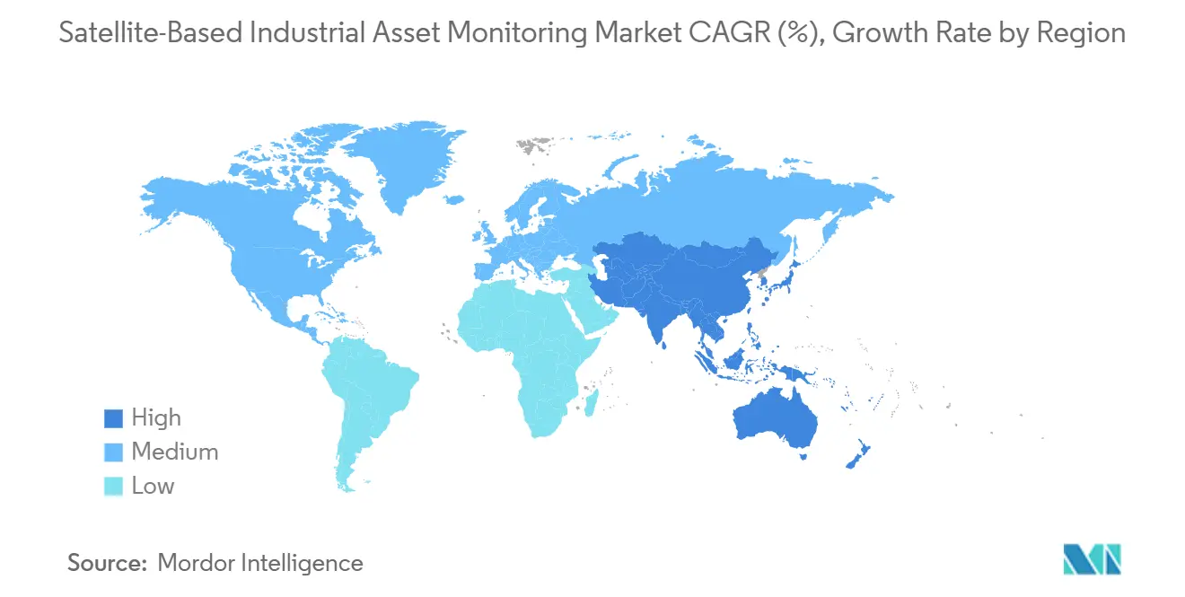
North America held 34.71% of the satellite-based industrial asset monitoring market share in 2025. US and Canadian oil and gas pipeline operators, supported by federal rules, formed an important base of regional demand. PHMSA formally authorized satellite imagery for pipeline right-of-way patrol in its April 2026 rulemaking, providing operators with a recognized compliance option for long, difficult-to-access corridors. Iridium completed on-air trials of Iridium NTN Direct in January 2026 and targeted commercial service for later in 2026. Established SCADA and automation infrastructure can support integration of satellite data with existing operating technology systems, rather than requiring operators to create entirely separate monitoring processes.
Asia-Pacific is projected to expand at a 14.33% CAGR from 2026 to 2031. Australian mining operations, India's satellite narrowband licensing work, and China's LEO IoT capacity support regional demand across locations with large distances between industrial assets and terrestrial networks. Satellite monitoring is used across Australian mining operations to monitor haul road conditions, mine wall deformation, and tailings dam integrity. This can replace helicopter surveys and provide more frequent observation for safety and operating teams. China’s commercial satellite IoT providers serve coal, rare earth, and industrial operators in remote areas, while mining safety guidance supports more consistent procurement practices across regional operations.
Europe is shaped by methane rules that recognize satellite monitoring as part of compliance activities. From 2027, EU fossil gas importers must demonstrate methane intensity below 0.2% across their supply chains, extending monitoring requirements to some producers supplying European demand. The Middle East and Africa combine Gulf investment in oil, gas, water infrastructure, and logistics with demand from remote mining and pipeline surveillance in Sub-Saharan Africa. Sateliot and Datakorum announced 5G NB-IoT connectivity for remote oil, gas, and water infrastructure in the United Arab Emirates during October 2025, while South America is supported by wellhead monitoring across Argentina, Colombia, Brazil, and Bolivia, copper districts in Chile and Peru, and shale activity in Argentina’s Vaca Muerta basin.

Competitive Landscape
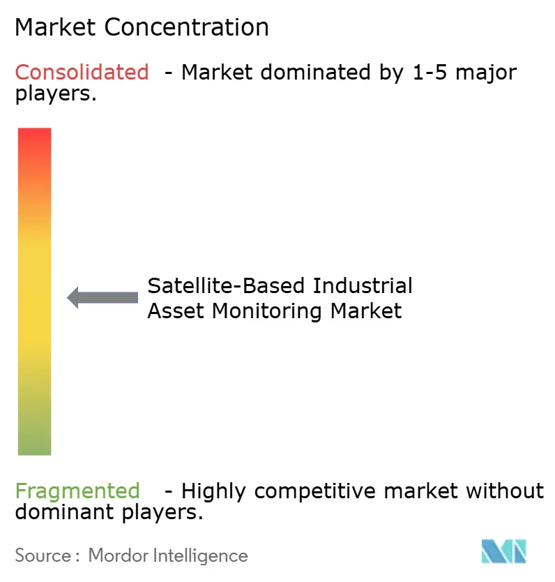
The satellite-based industrial asset monitoring market is moderately fragmented across operators, IoT specialists, and analytics providers. Established operators such as Iridium Communications, Hughes Network Systems, SES, and Eutelsat serve high-bandwidth and continuous-link uses where persistent transmission is important. These include offshore oil and gas operations, remote facilities, and maritime monitoring. LEO IoT specialists, including Kinéis, Myriota, Hiber, Astrocast, and Kepler Communications, compete on low power use, device cost, and broad coverage for low-data-rate periodic telemetry. The satellite-based industrial asset monitoring market has distinct supplier groups because periodic telemetry and continuous data links require different networks, terminals, and operating models.
Suppliers are placing more emphasis on analytics software, standards compatibility, and the ability to connect different forms of industrial equipment. 3GPP NTN interfaces can extend device access beyond proprietary terminal designs and can reduce the need to change hardware when a device moves between networks. Iridium and SKYWAVE announced a July 2026 partnership to embed Iridium Short Burst Data in OGx IoT platform terminals for heavy equipment makers. The combined satellite, cellular, and Wi-Fi arrangement supports remote monitoring, predictive maintenance, and diagnostics for equipment that operates in varying coverage conditions. Kinéis also commercially launched its LEO IoT service in June 2025 after constellation deployment, bringing an additional purpose-built option to industrial infrastructure and environmental monitoring users.
Middleware that places satellite telemetry directly into SCADA, CMMS, ERP, and GIS systems remains an important area for product development. Such software can reduce custom integration work and help industrial users view satellite data alongside their existing asset records, alerts, and work orders. Regulated customers also consider security controls and data sovereignty when selecting providers, making ground-segment security and standards compliance part of supplier evaluation alongside connectivity performance. The satellite-based industrial asset monitoring market is therefore not defined by coverage alone, and providers need to show that their data can be used reliably within existing industrial processes.
Satellite-Based Industrial Asset Monitoring Industry Leaders
Iridium Communications Inc.
ORBCOMM Inc.
Myriota Pty Ltd
Globalstar, Inc.
Astrocast SA
- *Disclaimer: Major Players sorted in no particular order

Recent Industry Developments
- July 2026: Iridium Communications and SKYWAVE, an ORBCOMM company, announced a partnership to embed Iridium Short Burst Data directly into SKYWAVE's OGx IoT platform terminals, providing heavy equipment OEMs with an integrated satellite, cellular, and Wi-Fi solution for remote monitoring, predictive maintenance, and diagnostics.
- June 2026: Kinéis and Dryad Networks deployed a wildfire early-detection and environmental monitoring solution using Kinéis nanosatellites and Dryad Silvanet sensors during France's 2026 wildfire season, providing multi-daily environmental alerts in areas without terrestrial coverage.
- February 2026: Deutsche Telekom launched the world's first multi-orbit IoT roaming service, integrating LEO connectivity from Sateliot and OQ Technology with GEO coverage from Skylo, enabling 3GPP NB-IoT devices to roam between terrestrial and satellite networks without hardware changes.
- January 2026: Iridium Communications completed on-air trials of Iridium NTN Direct, including two-way message transmission over its 66-satellite LEO constellation under 3GPP Release 19 NB-IoT standards, with commercial service targeted for the second half of 2026.


Global Satellite-Based Industrial Asset Monitoring Market Report Scope
Satellite-Based Industrial Asset Monitoring Market refers to earth-observation and geospatial analytics services that use optical, SAR (synthetic aperture radar), thermal, hyperspectral, and methane-detection satellite data to continuously monitor the condition, activity, and environment of industrial assets and infrastructure.
The Satellite-Based Industrial Asset Monitoring Market Report is Segmented by Component (Hardware, Software, and Services), Connectivity Type (LEO Satellite Connectivity, MEO Satellite Connectivity, GEO Satellite Connectivity, and Multi-Orbit Satellite Connectivity), Asset Type (Linear, Fixed Industrial, Mobile, Remote Assets), End-User Industry (Oil and Gas, Energy and Utilities, Mining and Metals, Transportation and Logistics, Maritime and Shipping, Agriculture and Forestry, Construction and Infrastructure, and Government, Defense and Public Safety), and Geography (North America, South America, Europe, Asia-Pacific, and Middle East and Africa). The Market Forecasts are Provided in Terms of Value (USD).
| Hardware |
| Software |
| Services |
| LEO Satellite Connectivity |
| MEO Satellite Connectivity |
| GEO Satellite Connectivity |
| Multi-Orbit Satellite Connectivity |
| Linear and Networked Infrastructure |
| Fixed Industrial Assets and Facilities |
| Mobile and Heavy Equipment |
| Remote and Environmental Assets |
| Oil and Gas |
| Energy and Utilities |
| Mining and Metals |
| Transportation and Logistics |
| Maritime and Shipping |
| Agriculture and Forestry |
| Construction and Infrastructure |
| Government, Defense and Public Safety |
| Other End-User Industry |
| North America | United States | |
| Canada | ||
| Mexico | ||
| South America | Brazil | |
| Argentina | ||
| Rest of South America | ||
| Europe | Germany | |
| United Kingdom | ||
| France | ||
| Italy | ||
| Spain | ||
| Rest of Europe | ||
| Asia-Pacific | China | |
| Japan | ||
| India | ||
| South Korea | ||
| ASEAN | ||
| Rest of Asia-Pacific | ||
| Middle East and Africa | Middle East | Saudi Arabia |
| United Arab Emirates | ||
| Turkey | ||
| Rest of the Middle East | ||
| Africa | South Africa | |
| Nigeria | ||
| Rest of Africa | ||
| By Component | Hardware | ||
| Software | |||
| Services | |||
| By Connectivity Type | LEO Satellite Connectivity | ||
| MEO Satellite Connectivity | |||
| GEO Satellite Connectivity | |||
| Multi-Orbit Satellite Connectivity | |||
| By Asset Type | Linear and Networked Infrastructure | ||
| Fixed Industrial Assets and Facilities | |||
| Mobile and Heavy Equipment | |||
| Remote and Environmental Assets | |||
| By End-User Industry | Oil and Gas | ||
| Energy and Utilities | |||
| Mining and Metals | |||
| Transportation and Logistics | |||
| Maritime and Shipping | |||
| Agriculture and Forestry | |||
| Construction and Infrastructure | |||
| Government, Defense and Public Safety | |||
| Other End-User Industry | |||
| By Geography | North America | United States | |
| Canada | |||
| Mexico | |||
| South America | Brazil | ||
| Argentina | |||
| Rest of South America | |||
| Europe | Germany | ||
| United Kingdom | |||
| France | |||
| Italy | |||
| Spain | |||
| Rest of Europe | |||
| Asia-Pacific | China | ||
| Japan | |||
| India | |||
| South Korea | |||
| ASEAN | |||
| Rest of Asia-Pacific | |||
| Middle East and Africa | Middle East | Saudi Arabia | |
| United Arab Emirates | |||
| Turkey | |||
| Rest of the Middle East | |||
| Africa | South Africa | ||
| Nigeria | |||
| Rest of Africa | |||


Key Questions Answered in the Report
What is the size of the satellite-based industrial asset monitoring market?
The satellite-based industrial asset monitoring market size was USD 4.08 billion in 2026 and is forecast to reach USD 7.77 billion by 2031 at a 13.75% CAGR. The satellite-based industrial asset monitoring market serves operators that need persistent oversight outside terrestrial coverage areas, especially for pipelines, remote facilities, and distributed environmental assets where regular physical inspection can be difficult to arrange.
Which component leads remote industrial monitoring spending?
Hardware led with 44.73% revenue share in 2025 because industrial deployments require ruggedized terminals, modems, and antenna assemblies. The satellite-based industrial asset monitoring market continues to rely on this equipment at sites exposed to demanding environmental conditions, vibration, humidity, and long distances from technical support. Equipment choices also affect installation planning, power management, and the reliability of field data collection.
Why is multi-orbit connectivity gaining attention?
Multi-orbit connectivity is projected to expand at a 14.21% CAGR through 2031 as operators seek resilience across orbital layers for critical telemetry. In the satellite-based industrial asset monitoring market, common device access can help reduce dependency on 1 orbit or service configuration and can retain communications as coverage conditions change across the operating life of industrial equipment. The satellite-based industrial asset monitoring market can use this flexibility when no single constellation meets every requirement.
Which end-user application is expanding fastest?
Mining and metals is projected to expand at a 14.27% CAGR through 2031 as operations extend into remote areas for copper, lithium, nickel, and gold. The satellite-based industrial asset monitoring market supports equipment tracking and subsurface intelligence in these dispersed operating areas where terrestrial communications infrastructure is limited or unavailable. For the satellite-based industrial asset monitoring market, monitoring can also support safer planning across large mining sites with difficult terrain.
What limits adoption of satellite monitoring systems?
Ruggedized equipment, airtime, remote installation, limited power, data throughput, and integration with legacy systems can raise deployment costs and complexity. Smaller participants in the satellite-based industrial asset monitoring market may find it difficult to spread these costs across a large asset base while meeting safety and operational requirements, particularly when individual locations only require intermittent readings.
Which region is advancing fastest in satellite-based asset monitoring?
Asia-Pacific is projected to expand at a 14.33% CAGR through 2031, supported by remote mining, satellite licensing activity, and LEO IoT capacity. The satellite-based industrial asset monitoring market has regional applications in mine safety, infrastructure observation, and remote industrial communications across locations with constrained cellular coverage, including areas where operators must monitor haul roads, tailings dams, remote equipment, and fixed infrastructure over large distances. Regional demand also reflects the need to provide regular information to operating teams without depending on local network buildout.
Page last updated on: