
Hydrographic Survey Equipment Market Size and Share
Market Overview
| Study Period | 2022 - 2032 |
|---|---|
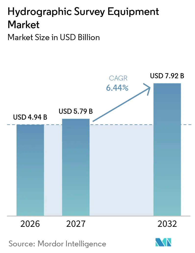
| Market Size (2027) | USD 5.79 Billion |
| Market Size (2032) | USD 7.92 Billion |
| Growth Rate (2027 - 2032) | 6.44 % |
| Fastest Growing Market | Asia-Pacific |
| Largest Market | North America |
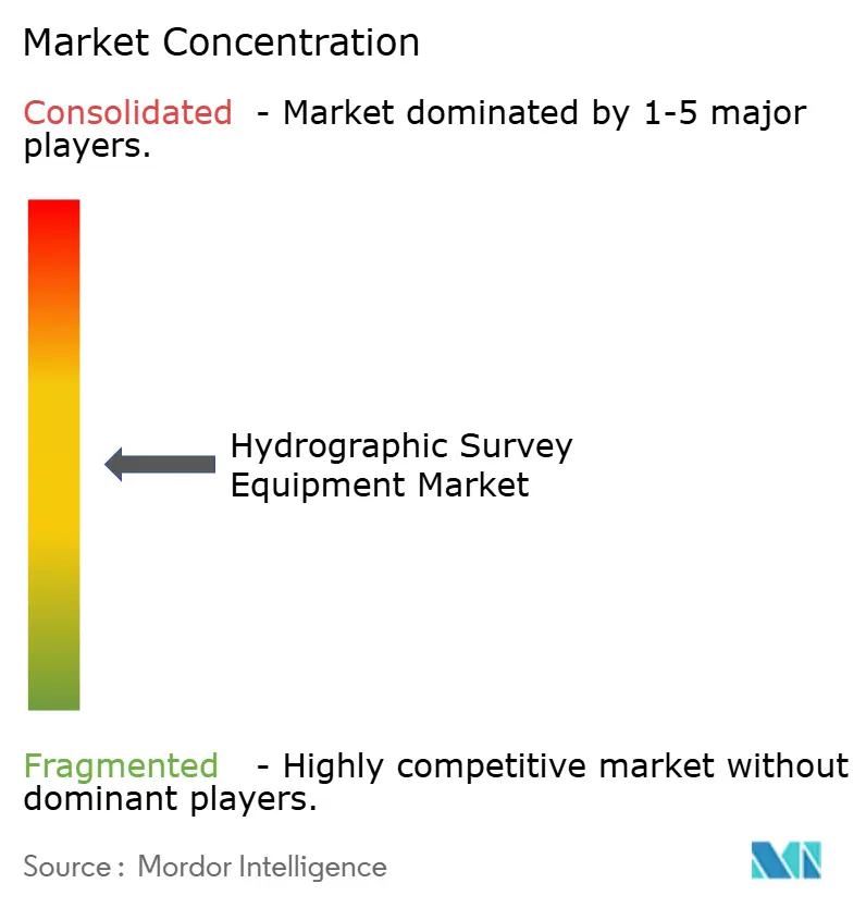
| Market Concentration | Medium |
Major Players *Disclaimer: Major Players sorted in no particular order Image © Mordor Intelligence. Reuse requires attribution under CC BY 4.0. | |
Hydrographic Survey Equipment Market Analysis by Mordor Intelligence
The hydrographic survey equipment market size was valued at USD 4.94 billion in 2026 and is estimated to grow from USD 5.97 billion in 2027 to reach USD 7.92 billion by 2032, at a CAGR of 6.43% during the forecast period (2027-2032). The market is supported by offshore wind development, subsea infrastructure activity, and public programs for nautical charting and exclusive economic zone mapping. Equipment demand is also shifting toward autonomous surface and underwater platforms, as these can extend survey coverage while reducing vessel dependence. IHO S-100 implementation is increasing the value of software capable of processing, exchanging, and validating hydrographic data across organizations.[1] The shortage of certified surveyors raises the value of automated mission planning and data quality control, although high system costs continue to limit adoption among smaller operators. The market also benefits from recurring port maintenance and coastal mapping work, which provides demand outside large offshore construction projects.
Key Report Takeaways
- By equipment type, sensing systems held 31.4% of the hydrographic survey equipment market share in 2026, while hydrographic survey software is forecast to grow at a 7.2% CAGR through 2032.
- By survey depth, shallow water held 62.5% of the hydrographic survey equipment market share in 2026, while ultra-deep water is forecast to grow at a 7.5% CAGR through 2032.
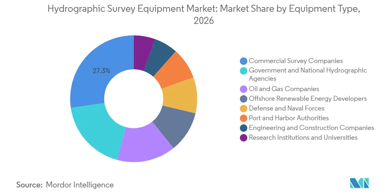
- By end user, commercial survey companies held 27.3% revenue share in 2026, while offshore renewable energy developers are forecast to grow at a 9.1% CAGR through 2032.
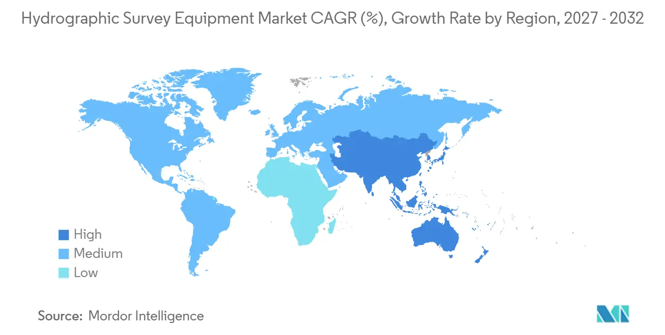
- By geography, North America held 35.7% revenue share in 2026, while Asia-Pacific is forecast to grow at a 6.9% CAGR through 2032.
Note: Market numbers in this report are based on Mordor Intelligence's proprietary estimation framework, which combines nine months of actuals with Q4 projections for base year 2026.
Market Trends and Insights
Drivers Impact Analysis of Hydrographic Survey Equipment Market*
| Driver | (~) % Impact on CAGR Forecast | Geographic Relevance | Impact Timeline |
|---|---|---|---|
| Offshore Wind and Subsea Infrastructure Build-Out | +1.5% | Global, strongest in Europe and APAC | Medium term (2-4 years) |
| Autonomous Surface and Underwater Survey Platforms | +1.2% | Global | Medium term (2-4 years) |
| Government Investment in Hydrographic and Maritime Safety Programs | +0.9% | Global, particularly North America, APAC, and MEA | Short term (≤ 2 years) |
| Coastal and Port Modernization | +0.7% | APAC, North America, and MEA | Medium term (2-4 years) |
| Offshore Oil and Gas Survey Investment | +0.8% | APAC, South America, MEA, and North America | Medium term (2-4 years) |
| Increasing Demand for High-Resolution Seabed Mapping and Marine Spatial Data | +1.0% | Global | Long term (≥ 4 years) |
| Source: Mordor Intelligence | |||
Offshore Wind and Subsea Infrastructure Build-Out
Offshore wind projects require seabed characterization before installation, during construction, and after assets enter service. The Global Wind Energy Council expects 77 GW of offshore wind capacity to connect globally between 2024 and 2030.[2] This pipeline supports demand across the hydrographic survey equipment market for multibeam echo sounders, sub-bottom profilers, positioning equipment, and survey processing software. Germany's Federal Maritime and Hydrographic Office issued tenders in August 2026 for North Sea EEZ zones 3 and 4, covering survey seasons in 2027 and 2028. Vietnam's offshore wind rules streamlined site survey approvals from March 2026, supporting the development pipeline described in its Power Development Plan VIII. Floating offshore wind creates additional demand because projects require deeper-water site work, cable-route assessment, and repeated monitoring.
Autonomous Surface and Underwater Survey Platforms
Autonomous platforms are changing how survey operators deploy sensors and collect data at sea. Fugro completed an autonomous MAREANO seabed mapping survey for the Norwegian Hydrographic Service in 2025 using the Blue Eclipse uncrewed surface vessel. Exail's DriX O-16 was validated in sea acceptance testing off France in 2026 and is scheduled for fourth-quarter mobilization with a Kongsberg EM124 full-ocean-depth multibeam echosounder. These deployments are reshaping equipment choices across the hydrographic survey equipment market. ACUA Ocean and Bedrock Ocean Exploration announced a 2026 partnership for AUV swarms launched from USV motherships. MIT Lincoln Laboratory reported that a fleet of 20 autonomous surface vehicles could provide up to 50 times the seabed coverage rate of a single underwater vehicle.
Government Investment in Hydrographic and Maritime Safety Programs
Government programs remain an important source of equipment demand in the hydrographic survey equipment market. The National Oceanic and Atmospheric Administration allocated USD 20 million in fiscal year 2025 for mapping critical mineral deposits in deep waters off American Samoa, with survey work beginning in February 2026.[3] This program links critical mineral policy with deep-water sensing and survey capacity. India's Ministry of Defence identified Cochin Shipyard Limited as the lowest bidder in February 2026 for 5 next-generation survey vessels valued at INR 5,000 crore (USD 595 million). The vessels are intended for EEZ charting, port surveys, and deep-water operations. The National Oceanic and Atmospheric Administration's Ocean and Coastal Mapping Center cooperative agreement provided USD 8.5 million for technology, cloud delivery, and AI-assisted data acquisition, strengthening demand for both software and hardware.
Increasing Demand for High-Resolution Seabed Mapping and Marine Spatial Data
The need for more complete seabed coverage continues to support long-term equipment demand. Seabed 2030 reported in April 2026 that 28.7% of the global ocean floor, or 104 million km², had been mapped. Nearly 5 million km² were added during the preceding year. The remaining 71.3% represents a long-term mapping requirement for governments, research institutions, and commercial operators, supporting continued demand in the hydrographic survey equipment market. Research published in the ISPRS Annals found that enhanced multibeam data achieved root mean square error below 3 meters in flat sandy areas. The UK Hydrographic Office uses large language models for varied submissions, while NORBIT's Layered Media Detection supports single-pass identification of fluid mud and navigable bottom.
Restraints Impact Analysis of Hydrographic Survey Equipment Market*
| Restraint | (~) % Impact on CAGR Forecast | Geographic Relevance | Impact Timeline |
|---|---|---|---|
| High System Integration and Ownership Costs | -0.7% | Global | Short term (≤ 2 years) |
| Shortage of Hydrographic and Data-Processing Specialists | -0.4% | Global, most acute in APAC and MEA | Medium term (2-4 years) |
| Survey Data-Processing and Interoperability Burden | -0.4% | Global | Medium term (2-4 years) |
| Marine Permitting, Acoustic-Noise and Environmental Constraints | -0.3% | North America and Europe | Short term (≤ 2 years) |
| Source: Mordor Intelligence | |||
High System Integration and Ownership Costs
A complete vessel survey configuration can cost more than USD 500,000 before ongoing licensing, calibration, and training expenses. Such a configuration can include multibeam echo sounders, GNSS equipment, motion reference units, sound velocity profilers, and processing software. Smaller contractors and government agencies may face difficult financing conditions while also meeting calibration and IHO validation requirements. Autonomous USVs can reduce operational costs over time, but capable systems still require upfront investment in the low millions. Ultra-deep-water AUVs also require expensive launch-and-recovery equipment and specialist support. These cost barriers can concentrate high-end adoption in the hydrographic survey equipment market among larger operators.
Shortage of Hydrographic and Data-Processing Specialists
The IHO updated its standards for Category A and Category B hydrographic surveyors in August 2026. The revised standards raise expectations for a workforce that is also learning remote mission planning, sensor quality assurance, and AI-supported validation. Graduates from IHO-accredited programs have not kept pace with demand from offshore wind, deep-sea mapping, and public charting programs. This shortfall can raise the cost of certified data processing during survey campaigns and influences buying decisions across the hydrographic survey equipment market, particularly among smaller firms. Data-processing workloads and format interoperability add further implementation pressure as users prepare for S-100-based exchange requirements.
*Our forecasts treat driver/restraint impacts as directional, not additive. The impact forecasts reflect baseline growth, mix effects, and variable interactions.
Hydrographic Survey Equipment Market Segment Analysis
By Equipment Type:
Sensing Systems Anchor Revenue, Software AcceleratesSensing systems held 31.4% of equipment revenue in 2026, representing the largest equipment share. Multibeam echo sounders, side-scan sonars, and sub-bottom profilers are required across a wide range of hydrographic survey equipment market applications. Teledyne Marine introduced the SeaBat D100 and SeaBat T51 Integrated Dual Head systems in March 2026 for deep-water vessel and ROV deployments. NORBIT introduced the WINGHEAD X in December 2025, featuring 0.5° beamwidth resolution and configurable hardware and software options. Kongsberg's agreement with Fugro established the EM2042 as a preferred sensor across Fugro's autonomous fleet.
Hydrographic survey software is forecast to record a 7.2% CAGR through 2032. Software upgrades are being driven by the operationalization of S-100 Phase 1 in January 2026 and the IMO transition date of January 1, 2029, which is creating a replacement cycle for electronic navigational chart workflows. Teledyne CARIS and the UK Hydrographic Office began a multiyear cloud services partnership in July 2025 covering CARIS HIPS and SIPS, Bathy DataBASE, and HPD. AI-based data cleaning is becoming a differentiator, as uncorrected multibeam outliers can reduce base surface accuracy. The hydrographic survey equipment market size for software is therefore tied to data quality, interoperability, and distributed collaboration requirements.

By Survey Depth:
Shallow Water Dominates, Ultra-Deep AcceleratesShallow water accounted for 62.5% of survey depth revenue in 2026. Offshore wind sites, harbor dredging, and coastal charting sustain shallow-water demand in the hydrographic survey equipment market. The U.S. Army Corps of Engineers conducted pre- and post-dredging bathymetric surveys at ports in Alaska, California, Texas, and the Pacific Northwest during 2025 and 2026. Medium-depth water, defined as 50 to 200 meters, is a practical operating range for autonomous surface vessels. Fugro's MAREANO work covered depths from 80 to 1,700 meters, demonstrating the broader utility of autonomous survey platforms. Sound velocity profilers and tide gauges remain necessary for reliable measurement across coastal and offshore sites.
Ultra-deep water is forecast to expand at a 7.5% CAGR through 2032. NOAA's American Samoa activity demonstrates public demand for deep-water sensing related to critical minerals. Fugro deployed its Echo Surveyor 8 AUV on a Petronas Carigali geohazard survey off Sabah during June through August 2026. JAMSTEC completed sea trials for its 8,000-meter-rated URASHIMA8000 AUV in 2025. The deep-water range of 200 to 2,000 meters also supports cable-route and pipeline pre-lay survey work. The hydrographic survey equipment market size for ultra-deep systems is supported by a range of mineral, energy, geohazard, and exploration assignments.
By End User:
Commercial Survey Companies Lead, Offshore Renewables Drive Fastest GrowthCommercial survey companies held 27.3% of end-user revenue in 2026. These companies serve multiple customer groups and consolidate equipment purchasing across offshore wind, government, and energy assignments. Their fleets increasingly combine crewed vessels with USV and AUV capabilities, favoring systems that support remote control, real-time quality control, and repeatable deployment. Fugro reported EUR 1.8 billion in revenue across 52 countries in 2025, illustrating the geographic scale of a major commercial survey operator. Commercial buyers therefore remain important technology adopters in the hydrographic survey equipment market.
Offshore renewable energy developers are forecast to advance at a 9.1% CAGR through 2032. Floating wind projects require deeper site characterization, longer cable-route surveys, and ongoing post-installation monitoring. Government and national hydrographic agencies remain significant purchasers through vessel programs and charting mandates. Oil and gas companies continued to commission integrated geophysical, geotechnical, and AUV work in 2026. Port authorities create recurring demand around dredging, while defense users, research institutions, and engineering firms support defined applications. The hydrographic survey equipment industry therefore serves both project-led and recurring survey requirements.
Geography Analysis
North America held 35.7% of the hydrographic survey equipment market in 2026. NOAA's charting mandate, U.S. Navy programs, and Army Corps waterway maintenance support this position. NOAA's five-year contract with Fugro, which started in January 2025 and runs through December 2029, covers hydrographic services supporting nautical chart creation. Executive Order 14285 directs attention toward offshore critical mineral mapping in U.S. waters, creating a path for deep-water AUV and sensing deployments beyond routine coastal charting.
Europe was the second-largest region in the hydrographic survey equipment market. North Sea wind development and established hydrographic institutions in the United Kingdom, Germany, Norway, and France supported regional equipment use. The OECD cited 77 GW of new EU offshore wind capacity expected to connect between 2024 and 2030. Norway's Hydrographic Service engaged Fugro for a NOK 44.7 million (USD 4.3 million) project for a 2025 MAREANO seabed mapping survey. France's DGA selected Exail in 2025 to develop a 6,000-meter-rated naval AUV. These programs support autonomous and deep-water capability development.
Asia-Pacific is projected to grow at a 6.9% CAGR through 2032. India commissioned INS Ikshak in November 2025 with an integrated AUV for deep-water hydrographic work, and a proposed five-vessel Indian survey fleet program reflects further public procurement in 2026. China has issued equipment tenders through August 2026 for maritime survey programs. South America and the Middle East and Africa are growing from lower bases through deepwater activity and charting needs. The hydrographic survey equipment market in these regions is supported by offshore energy, maritime boundary management, and incomplete ocean-floor coverage. The ROPME Sea Area improved mapped coverage from 6.4% to 20.5% in the 2026 GEBCO update.
Competitive Landscape
The hydrographic survey equipment market is moderately fragmented, with four to five broad system suppliers operating alongside specialized component and software providers. Kongsberg Gruppen and Teledyne Technologies maintain broad portfolios across multibeam systems, underwater positioning, and software. Kongsberg Gruppen's March 2026 framework agreement with Fugro covered EM2042 multibeam systems, Seapath GNSS and INS, and HiPAP acoustic positioning, giving Kongsberg Gruppen a preferred position within Fugro's autonomous fleet plans. NORBIT is a notable challenger through its modular multibeam product platform.
Technology capability is a primary basis for competition in the hydrographic survey equipment market. Buyers increasingly assess autonomous mission operation, real-time quality control, and S-100 compatibility alongside sensor performance. Exail's DriX O-16 integration with the Kongsberg Gruppen EM124 demonstrates the importance of partner-based system integration for full-ocean-depth uncrewed work. Kongsberg Gruppen's first commercial order for its Listen electromagnetic sensing solution involved a HUGIN 3000 AUV for work in Brazil. NORBIT added integrated sub-bottom profiling in July 2026 to combine bathymetric and sub-bottom data collection.[4] These developments aim to reduce survey passes and improve data collection efficiency.
Data-as-a-service models and AUV swarm operations remain open areas for commercial development. Specialized vendors can compete where buyers value form factor, specific sensor capability, or application depth. However, full-system providers retain an advantage when fleet operators require standard interfaces across multiple autonomous and crewed platforms. Disclosed combined top-player market shares are not available in the supplied material, and the available evidence supports a moderate concentration assessment rather than a market controlled by a small number of suppliers. Competition is likely to remain active as component vendors develop modular and interoperable products.
Hydrographic Survey Equipment Industry Leaders
-
Kongsberg Gruppen ASA
-
Teledyne Technologies Incorporated
-
Fugro N.V.
-
Trimble Inc.
-
Sonardyne International Ltd.
- *Disclaimer: Major Players sorted in no particular order
Hydrographic Survey Equipment Market Companies Covered in this Report
- AML Oceanographic
- Chesapeake Technology, Inc.
- Coda Octopus Group, Inc.
- EdgeTech
- Exail Technologies SA
- Fugro N.V.
- Furuno Electric Co., Ltd.
- GeoAcoustics Ltd.
- Hypack, Inc.
- Innomar Technologie GmbH
- Kongsberg Gruppen ASA
- NORBIT ASA
- R2Sonic, Inc.
- Saab AB
- Seafloor Systems, Inc.
- Sonardyne International Ltd.
- SyQwest Inc.
- Teledyne Technologies Incorporated
- Trimble Inc.
- Tritech International Limited
- Valeport Ltd.
- Wärtsilä ELAC Nautik GmbH
- Xylem Inc.
Recent Industry Developments in Hydrographic Survey Equipment Market
- September 2026: Fugro completed an ultra-deepwater geohazard survey for Petronas Carigali's Megah and Limbayong fields offshore Malaysia using the Echo Surveyor 8 AUV deployed from the Fugro Equator. The project marks the first AUV application within Petronas Carigali's ultra-deepwater program and utilizes real-time quality control through Fugro's Kuala Lumpur Remote Operations Centre.
- June 2026: Kongsberg Discovery deployed its EM 304 MKII multibeam echosounder aboard E/V Nautilus during the Pacific Mapping NA178 expedition, representing the first operational deployment of the company's next-generation full-ocean-depth multibeam survey system for deepwater hydrographic mapping.
- March 2026: Kongsberg Discovery and Fugro signed a main supplier framework agreement covering the deployment of EM2042 multibeam echosounders, Seapath GNSS/INS navigation systems, and HiPAP acoustic positioning systems across Fugro's survey fleet and autonomous surface vessels.
- March 2026: Teledyne Marine introduced the SeaBat D100 deepwater multibeam echosounder and the SeaBat T51 Integrated Dual Head survey system at Oceanology International 2026, expanding high-resolution hydrographic survey capabilities for survey vessels and deepwater ROV deployments.
Global Hydrographic Survey Equipment Market Report Scope
Hydrographic survey equipment refers to specialized instruments, sensors, positioning systems, and software used to measure, map, and analyze underwater environments, seabed features, and water depths. These tools collect hydrographic and bathymetric data for navigation safety, offshore construction, marine resource management, and environmental monitoring. Hydrographic survey equipment includes sonar systems, GNSS positioning systems, profilers, underwater sensors, and data processing software.
The global hydrographic survey equipment market is segmented by equipment type into sensing systems, positioning systems, optical systems, profilers and sensors, hydrographic survey software, and other equipment. By survey depth, the market is segmented into shallow water, medium-depth water, deep water, and ultra-deep water. By end user, the market is segmented into commercial survey companies, government and national hydrographic agencies, oil and gas companies, offshore renewable energy developers, port and harbor authorities, defense and naval forces, research institutions and universities, and engineering and construction companies. The report also covers the market size and forecasts for the global hydrographic survey equipment market across 26 countries in key regions. For each segment, the market sizing and forecasts are provided on the basis of value (USD).
Segmentation Overview
| Sensing Systems |
| Positioning Systems |
| Optical Systems |
| Profilers and Sensors |
| Hydrographic Survey Software |
| Other Equipment |
| Shallow Water |
| Medium-Depth Water |
| Deep Water |
| Ultra-Deep Water |
| Commercial Survey Companies |
| Government and National Hydrographic Agencies |
| Oil and Gas Companies |
| Offshore Renewable Energy Developers |
| Port and Harbor Authorities |
| Defense and Naval Forces |
| Research Institutions and Universities |
| Engineering and Construction Companies |
| North America | United States |
| Canada | |
| Mexico | |
| Europe | Germany |
| France | |
| Italy | |
| Spain | |
| United Kingdom | |
| Poland | |
| Russia | |
| Rest of Europe | |
| Asia-Pacific | China |
| India | |
| Japan | |
| South Korea | |
| Australia | |
| Indonesia | |
| Vietnam | |
| Thailand | |
| Rest of Asia-Pacific | |
| South America | Brazil |
| Argentina | |
| Chile | |
| Rest of South America | |
| Middle East and Africa | Saudi Arabia |
| United Arab Emirates | |
| Egypt | |
| South Africa | |
| Morocco | |
| Rest of Middle East and Africa |
| By Equipment Type | Sensing Systems | |
| Positioning Systems | ||
| Optical Systems | ||
| Profilers and Sensors | ||
| Hydrographic Survey Software | ||
| Other Equipment | ||
| By Survey Depth | Shallow Water | |
| Medium-Depth Water | ||
| Deep Water | ||
| Ultra-Deep Water | ||
| By End User | Commercial Survey Companies | |
| Government and National Hydrographic Agencies | ||
| Oil and Gas Companies | ||
| Offshore Renewable Energy Developers | ||
| Port and Harbor Authorities | ||
| Defense and Naval Forces | ||
| Research Institutions and Universities | ||
| Engineering and Construction Companies | ||
| By Geography | North America | United States |
| Canada | ||
| Mexico | ||
| Europe | Germany | |
| France | ||
| Italy | ||
| Spain | ||
| United Kingdom | ||
| Poland | ||
| Russia | ||
| Rest of Europe | ||
| Asia-Pacific | China | |
| India | ||
| Japan | ||
| South Korea | ||
| Australia | ||
| Indonesia | ||
| Vietnam | ||
| Thailand | ||
| Rest of Asia-Pacific | ||
| South America | Brazil | |
| Argentina | ||
| Chile | ||
| Rest of South America | ||
| Middle East and Africa | Saudi Arabia | |
| United Arab Emirates | ||
| Egypt | ||
| South Africa | ||
| Morocco | ||
| Rest of Middle East and Africa | ||
Key Questions Answered in the Report
What is the 2027 value of the hydrographic survey equipment market?
The market is valued at USD 5.79 billion in 2026 and is forecast to reach USD 7.92 billion by 2032, at a CAGR of 6.44%.
Which equipment category leads hydrographic survey spending?
Sensing systems led equipment revenue with a 31.4% share in 2026, while hydrographic survey software is forecast to record the highest CAGR at 7.2%.
Why are autonomous survey platforms significant?
Unmanned surface vehicles and autonomous underwater vehicles can extend survey coverage, support remote operations, and enable sensor deployment in deeper or more challenging environments.
Which survey depth segment has the strongest forecast growth?
Ultra-deep water is projected to grow at a CAGR of 7.5% through 2032, supported by mineral mapping, energy projects, and deep-ocean exploration.
Which end-user segment is expanding hydrographic equipment purchases fastest?
Offshore renewable energy developers are forecast to grow at a CAGR of 9.1% through 2032, as floating wind projects require extensive site and cable route surveys.
Which region has the fastest projected growth?
Asia-Pacific is forecast to grow at a CAGR of 6.9% through 2032, supported by government fleet modernization and offshore development activity.