
Drone Hyperspectral Inspection Market Size and Share
Market Overview
| Study Period | 2020 - 2031 |
|---|---|
| Market Size (2026) | USD 133.98 Million |
| Market Size (2031) | USD 278.26 Million |
| Growth Rate (2026 - 2031) | 15.74 % |
| Fastest Growing Market | Asia-Pacific |
| Largest Market | North America |
| Market Concentration | Medium |
Major Players *Disclaimer: Major Players sorted in no particular order Image © Mordor Intelligence. Reuse requires attribution under CC BY 4.0. | |
Drone Hyperspectral Inspection Market Analysis by Mordor Intelligence
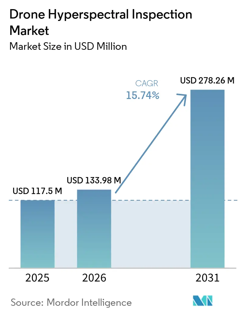
The Drone Hyperspectral Inspection Market size is projected to be USD 117.50 million in 2025, USD 133.98 million in 2026, and reach USD 278.26 million by 2031, expanding at a CAGR of 15.74% from 2026 to 2031. The shift from pilots to recurring work is most pronounced in areas where operators inspect mines, utilities, and public assets. Smaller sensors and onboard analytics make field collection more practical for commercial teams. Broader beyond visual line of sight approvals could improve the economics of long corridor surveys. Vendors are increasingly competing on integrated workflows rather than on sensor specifications alone. The strongest opportunities center on managed inspection services and validated spectral libraries that reduce adoption barriers for new users.
Key Report Takeaways
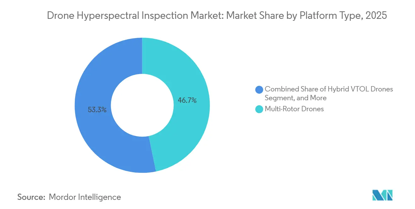
- By platform type, multi-rotor drones held 46.73% of the Drone Hyperspectral Inspection Market in 2025, while hybrid VTOL drones are projected to expand at an 18.93% CAGR through 2031.
- By sensor spectral range, VNIR held 48.61% share in 2025, while SWIR-II is projected to expand at an 18.47% CAGR through 2031.
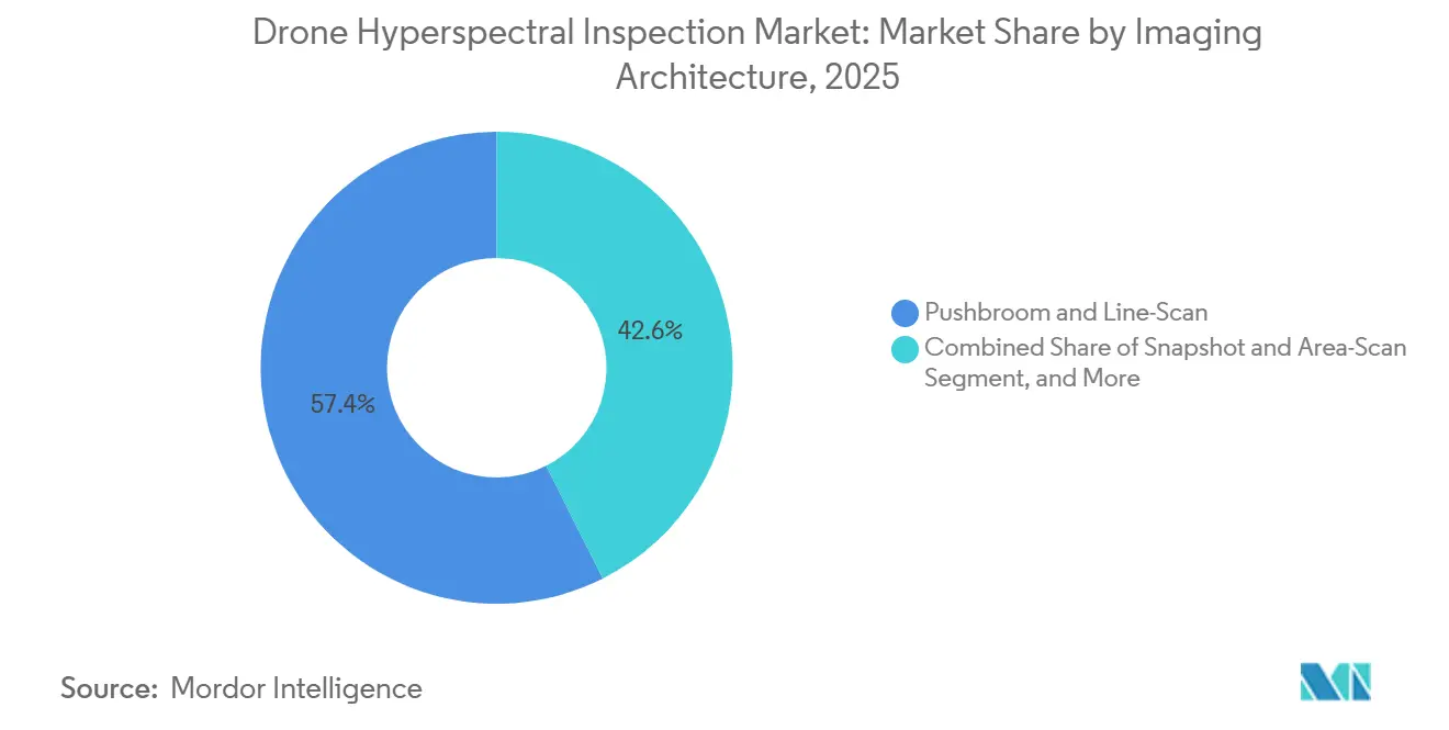
- By imaging architecture, pushbroom and line-scan systems held 57.43% share in 2025, while snapshot and area-scan systems are projected to expand at a 19.26% CAGR through 2031.
- By end-user industry, mining and metals held 24.83% share in 2025, while government and defense organizations are projected to expand at a 17.84% CAGR through 2031.
- By geography, North America held 34.71% share in 2025, while Asia-Pacific is projected to expand at an 18.21% CAGR through 2031.
Note: Market size and forecast figures in this report are generated using Mordor Intelligence’s proprietary estimation framework, updated with the latest available data and insights as of January 2026.
Global Drone Hyperspectral Inspection Market Trends and Insights
Drivers Impact Analysis*
| Driver | (~) % Impact on CAGR Forecast | Geographic Relevance | Impact Timeline |
|---|---|---|---|
| Miniaturized Hyperspectral Payloads for Small UAS | +3.2% | Global, strongest in North America and Asia-Pacific | Short term (≤ 2 years) |
| AI-Enabled Spectral Analytics for Near-Real-Time Inspection | +2.8% | Global, led by Asia-Pacific and North America | Medium term (2-4 years) |
| Frequent-Revisit Mining and Environmental Monitoring | +2.5% | Asia-Pacific, South America, Middle East and Africa, with spillover to Europe | Medium term (2-4 years) |
| Non-Destructive Infrastructure and Industrial Inspection | +2.2% | North America and Europe | Medium term (2-4 years) |
| Vertical-Face and Oblique-View UAS Inspection | +1.8% | North America and Europe, with spillover to Middle East and Africa | Long term (≥ 4 years) |
| Spectral Digital Twins for Asset and Terrain Monitoring | +1.5% | Global, with early adoption in North America and Northern Europe | Long term (≥ 4 years) |
| Source: Mordor Intelligence | |||
Miniaturization of Hyperspectral Payloads for Small UAS
Payload weight fell from 2.8 kg in 2018 to below 600 g in 2025 for snapshot instruments, expanding deployment options beyond large hexacopters and fixed-wing aircraft and broadening the available platform base for the Drone Hyperspectral Inspection Market.[1]Headwall Photonics, “Nano HP VNIR Hyperspectral Imaging System Is Ready to Fly on the DJI Matrice 350,” Headwall Photonics, headwall.com. Headwall Photonics launched the Nano HP VNIR system for the DJI Matrice 350 in November 2025. The company described it as the only hyperspectral payload with integrated LiDAR certified for that platform. The U.S. Army Small Business Innovation Research program continues to seek compact, internally calibrated sensors for Group 1 and Group 2 UAS. Lower payload mass reduces aircraft requirements and can simplify fleet deployment across dispersed inspection locations. The benefit is particularly relevant to service providers that must move equipment quickly among multiple client sites.[2]U.S. Army Small Business Innovation Research, “Miniaturization of Hyperspectral Sensors for UAS Applications,” U.S. Army, armysbir.army.mil.
AI-Enabled Spectral Analytics for Near-Real-Time Inspection
can be converted into usable field information. A 2025 study demonstrated onboard radiometric correction for 5,000 image frames within 1,000 ms on a VNIR pushbroom UAS, with Beijing flight trials planned for September 2026.[3]Jia Wan et al., “Onboard Real-Time Hyperspectral Image Processing System Design for Unmanned Aerial Vehicles,” Sensors, doi.org. Processing during a flight can reduce the delay caused by downloading and reviewing data after landing. This allows crews to examine anomalous areas while aircraft and personnel remain on site. It can also support a revised flight path when a relevant signal is detected. These capabilities increase the value of each flight hour when inspection locations are remote or access is restricted.
High-Resolution and Frequent-Revisit Needs in Mining and Environmental Monitoring
Mine sites require close-range spatial detail and repeat observations that satellites and manned surveys may not provide at the required pit scale. A 2025 project used VNIR-SWIR drone imagery at the Mary Kathleen uranium legacy mine in Queensland and mapped tailing-storage contamination at centimeter scale. A separate 2025 study used 400-2,500 nm data in Andong, South Korea, to map serpentinization and asbestos-related contamination risk. These use cases require spectral detail that multispectral sensors cannot provide. Frequent site surveys can support evidence needed for environmental monitoring and ore reconciliation. The Drone Hyperspectral Inspection Market therefore benefits where operators need both repeat coverage and site-level resolution.
Expansion of Non-Destructive Infrastructure and Industrial Inspection
Utilities are moving beyond visual inspection when RGB imagery cannot distinguish corrosion grades, material fatigue, or hydrocarbon leak signatures. Flyscan announced combined methane and liquid-leak detection using a HySpex SWIR camera and physics-based methane algorithms in April 2026, reporting 12 methane leaks across 4,400 miles of pipeline during one aerial pass.[4] Flyscan, “World’s First Methane and Liquid Leak Detection,” Flyscan, flyscan.com. Fraunhofer IOSB demonstrated oil-leak detection with a co-aligned VNIR-SWIR sensor over 4.2 ha at 4 cm pixel resolution within a 12-18-minute battery cycle. An IEEE study also validated spectral corrosion classification on high-voltage transmission towers. The Drone Hyperspectral Inspection Market can benefit when these assessments reduce the need for technicians to approach energized or difficult-to-access assets. The proposed U.S. Federal Aviation Administration Part 108 rule was still under review in July 2026 and, if finalized, could replace case-by-case waivers with standing approvals.
Restraints Impact Analysis*
| Restraint | (~) % Impact on CAGR Forecast | Geographic Relevance | Impact Timeline |
|---|---|---|---|
| Payload, Calibration, and Data-Processing Costs | -2.4% | Global, most acute in emerging markets and small and medium-sized service providers | Short term (≤ 2 years) |
| Limited Flight Endurance and Illumination Dependence | -1.8% | Global, with greater impact in high-latitude and humid equatorial regions | Medium term (2-4 years) |
| Weak Inspection and Mine-Planning Software Interoperability | -1.4% | Global, particularly in mature North American and European workflows | Medium term (2-4 years) |
| Limited Spectral Libraries and Mission-Ready Operators | -1.0% | Asia-Pacific, Middle East and Africa, and South America | Long term (≥ 4 years) |
| Source: Mordor Intelligence | |||
High Payload, Calibration, and Data-Processing Cost
A fully integrated system can exceed USD 150,000 before specialized operating support is included, limiting in-house ownership for smaller inspection service providers and encouraging subcontracting. SWIR grating spectrometers commonly weigh 2-3 kg, which can reduce multi-rotor endurance to 12-18 minutes. The same payload burden can limit a sortie to 4.2 ha at an altitude of 80 m. Dark-current correction, radiometric normalization, and atmospheric compensation add work before results can be delivered. Semiconductor tariff increases in 2025 raised exposure to the concentrated supply of InGaAs focal-plane arrays. These factors slow wider use of the Drone Hyperspectral Inspection Market among mining and infrastructure users.
Limited Flight Endurance and Illumination Dependence
while repeated battery swaps reduce the operational advantage that drones can offer over manned aircraft. VNIR sensors also require stable solar irradiance for accurate reflectance calibration. Cloud cover, low solar angles, and seasonal high-latitude conditions can compromise a session even when the equipment functions correctly. Fraunhofer IOSB recorded 12-18 minutes of endurance for a 2.83 kg VNIR-SWIR configuration. Hybrid VTOL platforms offer 4-6 hours under full payload, but heavier airframes can limit sensor selection and deployment flexibility across the Drone Hyperspectral Inspection Market. U.S. Federal Aviation Administration and European Union Aviation Safety Agency requirements also constrain commercial operations.
*Our forecasts treat driver/restraint impacts as directional, not additive. The impact forecasts reflect baseline growth, mix effects, and variable interactions.
Segment Analysis
By Platform Type: Multi-Rotor Leadership Faces Hybrid VTOL Endurance Pressure
Multi-rotor drones accounted for 46.73% of the Drone Hyperspectral Inspection Market share in 2025, supported by established payload integration options. Headwall and Specim offer pre-aligned VNIR packages for DJI Matrice aircraft. Vertical takeoff and landing suits close-range work around towers, mine faces, and industrial structures. The platform also allows crews to hover when a site needs repeat viewing angles. Fixed-wing aircraft continue to play a role in large agricultural and forestry surveys. Their endurance supports wider-area collection where runway or launch conditions allow operations. Single-rotor systems remain relevant for high-altitude sites and heavier mine-face payloads. These aircraft fill a narrower role where a multi-rotor configuration cannot safely carry the required equipment. The installed base of commercial multi-rotor platforms gives operators a familiar entry point into the Drone Hyperspectral Inspection Market.
Hybrid VTOL drones are projected to expand at an 18.93% CAGR from 2026 to 2031 within the Drone Hyperspectral Inspection Market. These systems combine vertical launch with fixed-wing cruise, thereby improving corridor coverage. Commercial models are available with 6-15 kg payload capacity and 4-10 hours of endurance. AeroVironment integrated the Arkeus HSOR payload with its JUMP 20 VTOL in September 2025. The company stated that the configuration has more than 13 hours of endurance and more than 500 nm of beyond-line-of-sight range. Longer flight time can reduce the number of launches required for a pipeline or transmission contract. This may lower per-hectare costs for service firms. It can also change how suppliers price wide-area inspections. The Drone Hyperspectral Inspection Market may therefore see hybrid aircraft used more often where distance is more important than hover capability.



By Sensor Spectral Range: VNIR Supports Established Uses While SWIR-II Advances
VNIR held 48.61% of the segment share in 2025 because its use cases are well established. The 400-1,000 nm range supports vegetation assessment, surface mineralogy, and pavement composition. CMOS-based detectors also provide a comparatively accessible technical path. Specim AFX10 and Headwall Nano HP series payloads support VNIR deployment on multi-rotor aircraft. Their integration with GNSS and IMU equipment can simplify survey setup. SWIR-I, covering 1,000-1,700 nm, supports moisture mapping and selected mineral classification. It also has uses in near-infrared hydrocarbon detection. This practical basis supports continued demand for VNIR within the Drone Hyperspectral Inspection Market.
SWIR-II is projected to expand at an 18.47% CAGR from 2026 to 2031, the highest rate among spectral ranges. The 1,700-2,500 nm range can distinguish clay minerals and carbonates with greater specificity. Mining companies use this information for mineral mapping and contamination analysis. Pipeline operators also need methane-related spectral signatures that rely on this broader coverage. Flyscan’s April 2026 announcement showed a commercial pipeline application using a HySpex SWIR pod. A 2025 study on uranium legacy mines found that co-aligned VNIR-SWIR data improved contamination-dispersal mapping. MWIR and LWIR remain specialized configurations for defense and high-temperature industrial monitoring. The Drone Hyperspectral Inspection Market is likely to retain these ranges for missions where their added spectral capability justifies a higher system cost.
By Imaging Architecture: Pushbroom Leads Corridors While Snapshot Gains in Confined Sites
Pushbroom and line-scan systems held 57.43% of the segment share in 2025. Their signal-to-noise performance supports georeferenced strip surveys along linear assets. The architecture also works naturally with forward motion on fixed-wing and hybrid VTOL aircraft. Established programs use processing tools such as ENVI, Pix4D, and Agisoft for post-flight workflows. These existing software pathways support adoption in professionally managed inspection programs. The systems are particularly suited to pipelines, transmission lines, and broad mine corridors. Their operating model depends on steady movement and repeatable flight geometry. That requirement is less favorable for hovering near complex structures. Even so, pushbroom systems remain the preferred approach for many corridor surveys in the Drone Hyperspectral Inspection Market.
Snapshot and area-scan systems are projected to expand at a 19.26% CAGR from 2026 to 2031. They capture a full hyperspectral cube in one acquisition without requiring platform motion. This feature suits multi-rotor inspections of vertical rock faces, solar panels, and confined industrial sites. Cubert’s ULTRIS X20 Plus was the subject of a U.S. Army sole-source procurement in August 2026. The procurement indicates that snapshot systems have entered government and defense buying channels. Spectricon’s MUSES9-DR provides acquisition and classification functions during flight. This reduces latency issues that have historically limited snapshot systems in time-sensitive work. Tunable-filter and Fourier-transform architectures remain specialized choices for narrow programmable bandpass selection or gas-phase resolution. Their higher cost and longer acquisition time limit their use to requirements that need these specific capabilities in the Drone Hyperspectral Inspection Market.
By End-User Industry: Mining Leads Adoption While Defense Drives the Highest Rate
Mining and metals held 24.83% of the segment share in 2025. Operators use hyperspectral imagery for ore-grade mapping, alteration-zone delineation, and tailing monitoring. Drone VNIR-SWIR data can provide spatial resolution 10-100 times finer than satellite hyperspectral imagery. Mining teams use this closer detail at active pits and legacy sites. The technology can integrate geological mapping and environmental monitoring within a single mission. Agriculture and forestry form the next important user group. They use VNIR data to identify crop stress and soil variability. Manned aircraft costs can make drone surveys more attractive for localized work. Mining retains the leading role because its operational and environmental needs rely on detailed, repeatable coverage.
Government and defense organizations are projected to expand at an 17.84% CAGR from 2026 to 2031. U.S. Army C5ISR procurement interest includes Vis-SWIR and LWIR hyperspectral imaging for UAS integration. India’s Army Aviation Corps also mandated hyperspectral capability for autonomous UAVs used in GPS-denied environments. These requirements support demand for sensors that operate across specialized missions. Utilities are also generating new commercial use cases. Elia Group extended its feasibility study for hyperspectral corrosion assessment on high-voltage metallic towers through 2025-2026. The work involved imec hardware and APIXA software. Inspection service providers and system integrators remain important because they spread high equipment costs across multiple clients. This role supports broader access to the Drone Hyperspectral Inspection Market without requiring each asset owner to purchase a full system.
Geography Analysis
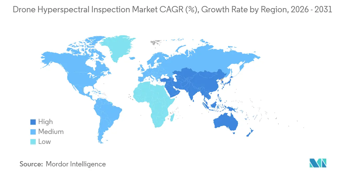
North America accounted for 34.71% of the Drone Hyperspectral Inspection Market share in 2025. U.S. federal defense procurement, a mature unmanned inspection ecosystem, and established oil and gas and utility applications supported regional demand. The U.S. Army issued sole-source solicitations for a Resonon Pika SWIR package in July 2026 and a Cubert ULTRIS X20 Plus system in August 2026. These purchases support sensor demand that is less dependent on commercial inspection cycles.
The Federal Aviation Administration implemented its Section 927 waiver process on April 1, 2026, streamlining beyond-visual-line-of-sight approvals for qualifying operations. The proposed Part 108 rule was under review in July 2026 and, if finalized, could replace case-by-case waivers with standing approvals. This could reduce planning friction for long pipeline and transmission inspections. North America retains an advantage where regulation and procurement support recurring large-area programs.
Asia-Pacific is projected to expand at an 18.21% CAGR from 2026 to 2031. China allocated CNY 1.15 billion, equivalent to USD 158 million, to hyperspectral research and development in 2025, while Chinese applicants held 32.5% of active hyperspectral patents in Q1 2026, up from 18.9% in 2020. Snapshot imaging, compressed-sensing reconstruction, and lightweight optics represented 61.4% of 3,120 global applications filed in 2025, while Japan’s domestic drone business reached JPY 497.3 billion, equivalent to USD 3.4 billion, in fiscal year 2025. India’s military requirement for GPS-denied UAS sensing supports domestic payload development. Europe remains a center for Specim, Cubert, Norsk Elektro Optikk, and Senop, while European projects validated VNIR-SWIR contamination monitoring in 2025, and European Union Aviation Safety Agency requirements complicate multi-country programs. The Middle East and Africa demand is tied to mining and oil and gas inspections, while South America relies on mining and precision agriculture surveys.

Competitive Landscape
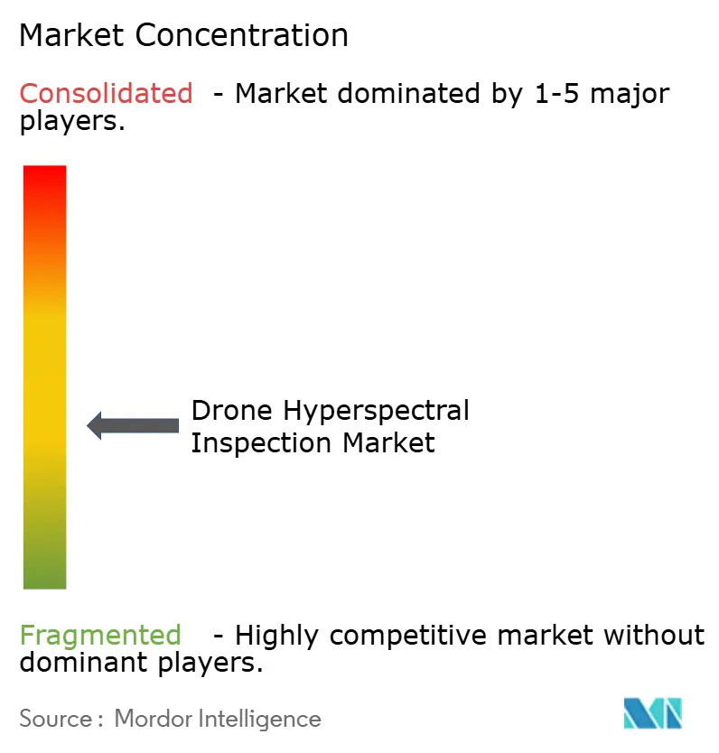
The Drone Hyperspectral Inspection Market was moderately fragmented in 2025, with leading vendors collectively holding 55% of global revenue. Headwall Photonics, Specim, Konica Minolta, Resonon, and Cubert form the core commercial sensor group. No vendor controls the sensor, platform, and analytics layers at the same time. Platform suppliers and service firms can create workflow-level switching costs by integrating those layers.
Headwall acquired inno-spec GmbH in November 2025, adding industrial hyperspectral imaging and data-processing capabilities. Headwall also partnered with GRYFN in April 2025 to connect sensor hardware with cloud-based data management. Cubert joined the Emtek Hyperspectral Group in November 2025, with investment intended to support its snapshot camera line and expansion in defense, environmental analysis, and industrial inspection. AeroVironment’s 2025 work with Arkeus brought a hyperspectral payload to the JUMP 20 VTOL platform. These moves combine hardware, data handling, and aircraft capability.
Managed beyond-visual-line-of-sight services can bundle platforms, sensors, and asset-management systems. Validated spectral libraries can reduce mission-planning risk for first-time users. Application-layer firms may link hyperspectral data cubes to mine-planning and SCADA software. Silicon-on-insulator photonic integrated circuits for SWIR sensing may place cost pressure on sensor specialists.
Drone Hyperspectral Inspection Industry Leaders
Specim, Spectral Imaging Ltd.
Headwall Photonics, Inc.
Cubert GmbH
Resonon, Inc.
BaySpec, Inc.
- *Disclaimer: Major Players sorted in no particular order

Recent Industry Developments
- April 2026: Flyscan announced the world's first combined methane-and-liquid-leak detection using its HySpex SWIR pod with new physics-based methane algorithms, identifying 12 methane leaks across 4,400 miles of pipeline in a single aerial pass. Commercial launch targets Q4 2026.
- April 2026: The FAA implemented Section 927 of the FAA Reauthorization Act of 2024, establishing a waiver-based BVLOS approval pathway that complements the pending Part 108 rulemaking and directly benefits providers conducting corridor-length hyperspectral inspection missions.
- November 2025: Headwall Photonics launched the Nano HP VNIR system for the DJI Matrice 350, the only hyperspectral payload with integrated LiDAR certified for this platform, expanding its multi-rotor addressable market beyond the Nano-Hyperspec generation.
- November 2025: Headwall Photonics acquired inno-spec GmbH, a 20-year industrial hyperspectral imaging and data processing specialist, consolidating sensor hardware and analytics capability to broaden its addressable market from airborne remote sensing into inline industrial inspection.


Global Drone Hyperspectral Inspection Market Report Scope
Drone Hyperspectral Inspection refers to the deployment of uncrewed aerial vehicles equipped with advanced hyperspectral imaging sensors that capture detailed spectral data across numerous narrow wavelength bands, enabling precise material identification, vegetation health analysis, and structural anomaly detection from the air for advanced remote sensing, environmental monitoring, and predictive maintenance applications.
The Drone Hyperspectral Inspection Market Report is Segmented by Platform Type (Fixed-Wing Drones, Multi-Rotor Drones, Single-Rotor Drones, and Hybrid VTOL Drones), Sensor Spectral Range (VNIR, 400-1,000 nm, SWIR-I (NIR-SWIR), 1,000-1,700 nm, SWIR-II, 1,700-2,500 nm, and MWIR and LWIR, above 2,500 nm), Imaging Architecture (Pushbroom and Line-Scan, Snapshot and Area-Scan, Tunable-Filter, Fourier-Transform and Interferometric, and Other Imaging Architectures), End-User Industry (Mining and Metals Companies, Utilities and Infrastructure Operators, Agriculture and Forestry Enterprises, Government and Defense Organizations, Industrial and Manufacturing Enterprises, Inspection Service Providers and System Integrators, Research Institutions, and Other End-User Industries), and Geography (North America, South America, Europe, Asia-Pacific, Middle East and Africa). The Market Forecasts are Provided in Terms of Value (USD).
| Fixed-Wing Drones |
| Multi-Rotor Drones |
| Single-Rotor Drones |
| Hybrid VTOL Drones |
| VNIR, 400-1,000 nm |
| SWIR-I (NIR-SWIR), 1,000-1,700 nm |
| SWIR-II, 1,700-2,500 nm |
| MWIR and LWIR, above 2,500 nm |
| Pushbroom and Line-Scan |
| Snapshot and Area-Scan |
| Tunable-Filter |
| Fourier-Transform and Interferometric |
| Other Imaging Architectures |
| Mining and Metals Companies |
| Utilities and Infrastructure Operators |
| Agriculture and Forestry Enterprises |
| Government and Defense Organizations |
| Research Institutions |
| Other End-User Industries |
| North America | United States | |
| Canada | ||
| Mexico | ||
| South America | Brazil | |
| Argentina | ||
| Rest of South America | ||
| Europe | Germany | |
| United Kingdom | ||
| France | ||
| Italy | ||
| Spain | ||
| Rest of Europe | ||
| Asia-Pacific | China | |
| Japan | ||
| India | ||
| South Korea | ||
| Rest of Asia-Pacific | ||
| Middle East and Africa | Middle East | Saudi Arabia |
| United Arab Emirates | ||
| Turkey | ||
| Rest of the Middle East | ||
| Africa | South Africa | |
| Nigeria | ||
| Rest of Africa | ||
| By Platform Type | Fixed-Wing Drones | ||
| Multi-Rotor Drones | |||
| Single-Rotor Drones | |||
| Hybrid VTOL Drones | |||
| By Sensor Spectral Range | VNIR, 400-1,000 nm | ||
| SWIR-I (NIR-SWIR), 1,000-1,700 nm | |||
| SWIR-II, 1,700-2,500 nm | |||
| MWIR and LWIR, above 2,500 nm | |||
| By Imaging Architecture | Pushbroom and Line-Scan | ||
| Snapshot and Area-Scan | |||
| Tunable-Filter | |||
| Fourier-Transform and Interferometric | |||
| Other Imaging Architectures | |||
| By End-User Industry | Mining and Metals Companies | ||
| Utilities and Infrastructure Operators | |||
| Agriculture and Forestry Enterprises | |||
| Government and Defense Organizations | |||
| Research Institutions | |||
| Other End-User Industries | |||
| By Geography | North America | United States | |
| Canada | |||
| Mexico | |||
| South America | Brazil | ||
| Argentina | |||
| Rest of South America | |||
| Europe | Germany | ||
| United Kingdom | |||
| France | |||
| Italy | |||
| Spain | |||
| Rest of Europe | |||
| Asia-Pacific | China | ||
| Japan | |||
| India | |||
| South Korea | |||
| Rest of Asia-Pacific | |||
| Middle East and Africa | Middle East | Saudi Arabia | |
| United Arab Emirates | |||
| Turkey | |||
| Rest of the Middle East | |||
| Africa | South Africa | ||
| Nigeria | |||
| Rest of Africa | |||


Key Questions Answered in the Report
What is the size of the Drone Hyperspectral Inspection Market?
The Drone Hyperspectral Inspection Market is projected to be USD 133.98 million in 2026 and reach USD 278.26 million by 2031, at a 15.74% CAGR.
Which drone platform leads hyperspectral inspection adoption?
Multi-rotor drones held 46.73% share in 2025 because they support hover operations and established commercial payload integrations.
Why is SWIR-II gaining adoption for inspections?
SWIR-II is projected to expand at an 18.47% CAGR through 2031 because it supports mineral discrimination and methane-related sensing.
What is the fastest-growing imaging architecture?
Snapshot and area-scan systems are projected to expand at a 19.26% CAGR through 2031, supported by single-acquisition imaging at confined sites.
Which region is expected to expand most quickly?
Asia-Pacific is projected to expand at an 18.21% CAGR through 2031, supported by Chinese research investment and Indian defense demand.
What restricts wider deployment of hyperspectral drones?
System cost, limited flight endurance, unstable illumination, software gaps, and shortages of spectral libraries and trained operators remain key constraints.
Page last updated on:


 Your data is secure and never sold or shared.