
Autonomous Drone Inspection Systems Market Size and Share
Market Overview
| Study Period | 2020 - 2031 |
|---|---|
| Market Size (2026) | USD 2.86 Billion |
| Market Size (2031) | USD 8.01 Billion |
| Growth Rate (2026 - 2031) | 22.87 % |
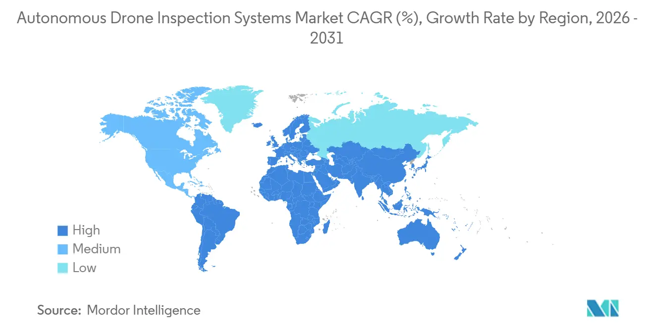
| Fastest Growing Market | Middle East and Africa |
| Largest Market | North America |
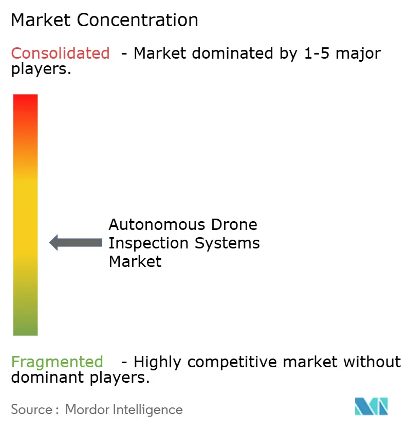
| Market Concentration | Medium |
Major Players *Disclaimer: Major Players sorted in no particular order Image © Mordor Intelligence. Reuse requires attribution under CC BY 4.0. | |
Autonomous Drone Inspection Systems Market Analysis by Mordor Intelligence
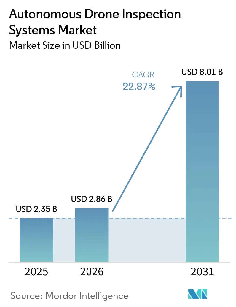
The Autonomous Drone Inspection Systems Market size is expected to expand from USD 2.35 billion in 2025 to USD 2.86 billion in 2026, and is forecast to reach USD 8.01 billion by 2031, at a 22.87% CAGR over 2026-2031. The autonomous drone inspection systems market is shifting from periodic, personnel-led inspections to continuous aerial monitoring that captures structured inspection data. Asset owners are using these systems where access is difficult, inspections are repeated often, or worker exposure is a concern. Regulatory progress on beyond-visual-line-of-sight operations is important because it determines whether operators can manage flights across large asset portfolios. Platform providers are also building stronger positions through software, site data, and links to maintenance records, rather than through aircraft sales alone. Procurement is shifting toward certified domestic hardware in parts of the United States following DJI's addition to the FCC Covered List in December 2025 and the introduction of the American Security Robotics Act in 2026.
Key Report Takeaways
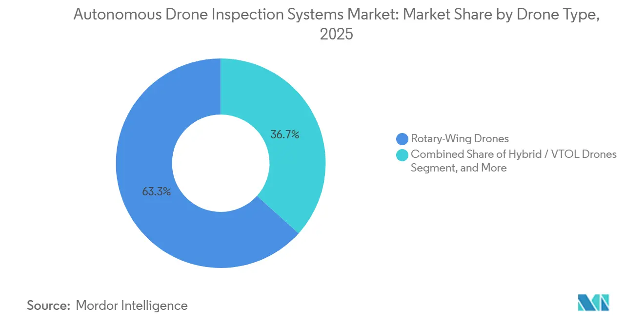
- By drone type, rotary-wing drones held 63.33% of the Autonomous Drone Inspection Systems Market share in 2025. Hybrid and VTOL drones are projected to expand at 27.71% CAGR through 2031.
- By autonomy level, semi-autonomous and human-in-the-loop systems accounted for 51.33% of the share in 2025. Adaptive AI and autonomous navigation are projected to expand at 28.54% CAGR through 2031.
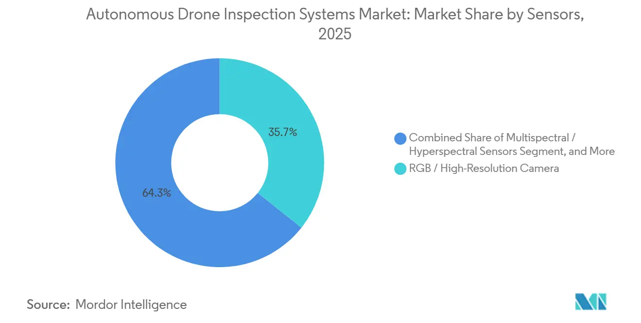
- Among sensors, RGB and high-resolution cameras held 35.68% of the Autonomous Drone Inspection Systems Market share in 2025. Multispectral and hyperspectral sensors are projected to expand at 28.31% CAGR through 2031.
- By end-user industry, energy and power accounted for 26.41% of the share in 2025. Mining and metals are projected to expand at 25.10% CAGR through 2031.
- By geography, North America accounted for 32.18% of the Autonomous Drone Inspection Systems Market share in 2025. The Middle East and Africa are projected to expand at 27.12% CAGR through 2031.
Note: Market size and forecast figures in this report are generated using Mordor Intelligence’s proprietary estimation framework, updated with the latest available data and insights as of January 2026.
Global Autonomous Drone Inspection Systems Market Trends and Insights
Drivers Impact Analysis*
| Driver | (~) % Impact on CAGR Forecast | Geographic Relevance | Impact Timeline |
|---|---|---|---|
| Aging Critical Infrastructure and Inspection Backlogs | +5.8% | Global, highest concentration in North America and Europe | Long term (≥ 4 years) |
| AI-Based Defect Detection and Automated Reporting | +5.0% | Global, early acceleration in North America and China | Medium term (2-4 years) |
| Expansion of BVLOS Operating Permissions | +4.2% | North America and Europe, spillover to Asia-Pacific and Middle East and Africa | Medium term (2-4 years) |
| Growth of Renewable Energy and Distributed Assets | +3.5% | Global, highest concentration in Asia-Pacific and Middle East and Africa | Long term (≥ 4 years) |
| Centralized Multi-Drone Remote Operations | +2.0% | North America and Europe, early gains in the Middle East | Medium term (2-4 years) |
| Inspection Data Integration With Digital Twins and Asset Management Systems | +1.5% | Global, early adoption in Europe and North America | Long term (≥ 4 years) |
| Source: Mordor Intelligence | |||
Aging Critical Infrastructure Fueling Autonomous Inspection Adoption
Aging infrastructure has created inspection backlogs that periodic human-led processes cannot address quickly. This supports recurring demand for autonomous aerial monitoring across industrial assets. Workforce shortages are especially acute in rope-access and confined-space work, where experienced specialists are scarce. A 2025 ConocoPhillips trial at the Greatham Tank Farm found that one autonomous flight captured 250 optical and thermal images in 16 minutes. The comparable ground inspection covered the same area in 8 hours.[1]ConocoPhillips, “Aerial Ambitions: Teesside Tests Autonomous Drones,” SpirItNow Stories, conocophillips.com. Remote pipelines, offshore sites, and elevated transmission lines create the strongest productivity case for the autonomous drone inspection systems market.
AI-Based Defect Detection Shifting Inspection Value Chains
Onboard and edge AI bring defect identification closer to where data is captured. This reduces the dependence on post-flight review for routine inspection work. A 2026 study of UAV imagery for power transmission infrastructure reported 88.5% mAP@0.5 detection performance. The same research reported 3-fold higher coverage capacity and up to 70% faster defect remediation.[2]T. Qazaq et al., “Deep Learning-Based Visual Analytics for Efficiency and Safety Optimization in Power Infrastructure,” Drones, mdpi.com. Percepto launched its next-generation inspection intelligence platform in June 2026, combining aircraft, onboard autonomy, contextual AI, and asset intelligence software. Site-specific data accumulation can make providers harder to replace once their models are linked to local asset histories.
BVLOS Regulatory Expansion Enabling Centralized Operations
Beyond visual line of sight, approval determines whether autonomous inspections can scale beyond individual sites. The Federal Aviation Administration published its proposed Part 108 rule on August 7, 2025. The proposal would replace certain case-by-case waiver requirements with performance-based operating criteria.[3]Federal Aviation Administration, “Normalizing Unmanned Aircraft Systems Beyond Visual Line of Sight Operations,” Federal Register, federalregister.gov. Aker Solutions received full unlimited BVLOS certification in Europe in September 2025, enabling offshore flights from an onshore control room. National Grid launched centralized autonomous aerial inspections for electricity infrastructure in England and Wales during September 2025. These approvals reduce staffing per inspection and support service models for smaller asset owners.
Renewable Energy Expansion Broadening the Inspectable Asset Base
Renewable generation increases the installed base of solar and wind and supports grid assets that require regular inspections. IRENA reported 585 GW of renewable capacity additions during 2024.[4]International Renewable Energy Agency, “Renewable Capacity Statistics 2025,” International Renewable Energy Agency, irena.org. These assets need panel, blade, structural, and transmission inspections throughout their operating lives. vHive introduced a multi-drone platform for thermal imaging, RGB mapping, and digital twin creation at utility-scale solar sites in July 2026. Remote deserts, offshore zones, and high-altitude sites often have limited inspection labor. The IEC 62446 series also supports recurring photovoltaic maintenance activity that can underpin multi-year inspection contracts.
Restraints Impact Analysis*
| Restraint | (~) % Impact on CAGR Forecast | Geographic Relevance | Impact Timeline |
|---|---|---|---|
| Fragmented BVLOS Regulations and Approval Requirements | -3.5% | Global, most acute in North America and Europe | Short term (≤ 2 years) |
| High Cost of Certified Autonomous Hardware and Docking Infrastructure | -3.0% | Global, most acute in Middle East and Africa and South America | Medium term (2-4 years) |
| Cybersecurity and Data Sovereignty Requirements for Critical Infrastructure | -2.0% | North America and Europe, spillover to Middle East and Africa | Medium term (2-4 years) |
| Limited Ground-Truth Data for Rare Defect Detection | -1.5% | Global | Long term (≥ 4 years) |
| Source: Mordor Intelligence | |||
Fragmented BVLOS Frameworks Constraining Multi-Jurisdiction Scalability
Fragmented BVLOS rules require operators to maintain separate approval packages across jurisdictions. Aircraft configurations and operating procedures can also differ by country. The proposed FAA Part 108 rule received more than 3,000 comments and remained under review during July 2026. European U-space requirements and the United States UTM model can lead to differences in platform design. This reduces portability for inspection programs operating across borders. Faster-moving jurisdictions can also strengthen incumbent operators that secure approvals before their rivals do.
High Infrastructure Costs Slowing Mid-Market Adoption
Autonomous inspection deployment requires more than an aircraft and a camera. Certified docking stations, edge computing, communications redundancy, and asset-management links add to the initial cost. Drone-in-a-box systems with weatherproof docking and certification can require a six-figure investment before commercial operations begin. Solid-state LiDAR and hyperspectral payloads are typically used where the inspection value justifies their cost. This creates a gap between large infrastructure owners and smaller operators. Drone-as-a-service models can lower the barrier to entry by selling inspection results rather than hardware ownership.
*Our forecasts treat driver/restraint impacts as directional, not additive. The impact forecasts reflect baseline growth, mix effects, and variable interactions.
Segment Analysis
By Drone Type: Rotary-Wing Leadership Supports Close-Range Inspection
Rotary-wing drones held 63.33% of the share in 2025. Their hover stability supports controlled sensor positioning near tanks, boiler chambers, substations, and offshore modules. They are suited to confined spaces and close-range data capture. Existing rules for proximity operations also align more readily with rotary-wing mission profiles. Fixed-wing aircraft retain a role in long-distance pipeline and transmission line surveys because their endurance enables them to survey long linear corridors.
Hybrid and VTOL platforms are projected to grow at 27.71% CAGR during 2026-2031. They combine fixed-wing endurance with multirotor maneuverability for large mines and offshore wind sites. A 2026 Scientific Reports study tested VTOL platforms along an 87.5 km, 220 kV power-line corridor. It processed 127,853 image triplets across 36 sorties at 42 milliseconds per frame and reported 98.4% field precision. The DJI Matrice 4D received standalone C6 certification in Europe in July 2026, enabling mobile deployment without fixed docking infrastructure.



By Autonomy Level: Adaptive AI Expands Mission Capability
Semi-autonomous and human-in-the-loop systems held 51.33% of the share in 2025. Operators continue to retain human decision-making during the transition toward wider autonomous approvals. These systems can meet regulatory requirements even when fully autonomous flight remains unavailable. They provide an entry point for building operational data and internal governance. Fully autonomous, pre-programmed systems are well-suited to repetitive corridor tasks, including solar panel surveys and substation perimeter checks.
Adaptive AI and autonomous navigation are forecast to grow at 28.54% CAGR during 2026-2031. These systems can adjust routes, sensor settings, and inspection priorities based on site conditions and asset inputs. Skydio deployments across more than 280 utility companies show the growing use of adaptive inspection systems. A Skydio X10 inspection at a Southern California Edison substation identified loose pivot bolts that ground crews did not detect. The reported finding avoided a 30-day service outage, while models trained on 18 months of site data can increase replacement costs.
By Sensors: RGB Cameras Lead While Spectral Payloads Accelerate
RGB and high-resolution cameras accounted for 35.68% of the autonomous drone inspection systems market size in 2025. Their lower cost supports broad use in structural inspections. Large image datasets also support visual defect detection models. Thermal and infrared cameras complement visible-light payloads by identifying electrical hot spots and photovoltaic temperature anomalies. Gas and chemical sensors serve oil and gas applications, where optical gas imaging supports compliance activity.
Multispectral and hyperspectral sensors are expected to grow at 28.31% CAGR through 2031. They support solar defect grading, mineral mapping, and vegetation assessment along transmission corridors. Origin Energy signed a multi-year agreement with Pointerra in July 2026 for drone-LiDAR monitoring of 750 km of gas pipelines in Queensland. The agreement links payload data to enterprise asset-management workflows. NEOM Energy deployed BlueSun Technology Solar-LIT inspection UAVs at Al-Ula Solar Park under a USD 28 million contract, while Saudi data residency requirements can favor on-device processing.
By End-User Industry: Energy Leads While Mining Expands
Energy and power accounted for 26.41% of the autonomous drone inspection systems market in 2025. Grid networks, wind farms, and solar parks require repeated inspection across dispersed assets. The sector has experience procuring multi-year inspection service contracts, while oil and gas is a related offshore application. Aker BP completed the first offshore BVLOS inspection from an onshore control room at the Edvard Grieg platform in 2025. Construction, marine, and telecommunications users are also adopting systems to reduce confined-space entry and shorten inspection cycles.
Mining and metals is forecast to grow at 25.10% CAGR during 2026-2031. Remote extraction sites and GPS-denied underground environments increase the value of autonomous inspection. SQM used autonomous DJI Dock-based drones across its 678 km² Chilean lithium operation, producing classified zone maps within 90 minutes of each flight. Critical Metals Corp deployed an autonomous Nexus 20 communications tower and drone system at its Tanbreez rare-earth project in Greenland during January 2026. Remote operation from Perth, Australia, enables real-time geological imaging at the project site.
Geography Analysis
North America held 32.18% of the autonomous drone inspection systems market share in 2025. The region has a developed BVLOS waiver record, a large base of drone inspection providers, and active federal procurement. Percepto received nationwide FAA BVLOS approval for centralized remote operation of up to 30 simultaneous drones. Canada’s 2026 cybersecurity guidance recommends a zero-trust architecture for drone systems that handle sensitive data, favoring stacks with stronger data controls.
Europe is the second-largest regional market. It combines strict data-governance requirements with increasing BVLOS activity. Aker Solutions’ 2025 certification and National Grid’s centralized inspection launch show operating progress. The EU Data Act entered into force in September 2025, while the German NIS2 implementation, starting in December 2025, increased attention to auditable data paths. This can differentiate vendors that offer localized and auditable processing.
Asia-Pacific activity is led by China, where DJI Enterprise won a CNY 1.83 billion procurement contract, equivalent to USD 250 million, from State Grid Corporation of China in March 2026. The contract covers ultra-high-voltage lines, urban substations, and distribution networks across 26 provinces. India represents a medium-term growth area as BVLOS permissions expand alongside the National Electricity Plan. The Middle East and Africa are projected to expand at a 27.12% CAGR during 2026-2031, supported by renewable energy investment and remote asset locations. Dubai Roads and Transport Authority reduced metro tunnel inspection time by 60% after deploying drone inspections in 2025. South American adoption is concentrated in mining, where Chile’s SQM is operating autonomous inspection across large open-pit sites.

Competitive Landscape
The autonomous drone inspection systems market is moderately fragmented. Hardware manufacturers, integrated inspection providers, and application software firms compete in different parts of the value chain. DJI competes through aircraft economics and payload choice, as shown by its March 2026 State Grid contract. Percepto, Flyability, and DroneDeploy compete by linking inspections with software and enterprise asset records. These connections can produce recurring revenue beyond an initial aircraft sale.
Percepto launched its next-generation platform for energy infrastructure operators in June 2026, combining Percepto Air drones, onboard autonomy, contextual AI, and AIM software. DJI released independent cybersecurity assessment findings for the Matrice 4E and Air 3S platforms in May 2026, covering data sovereignty, hardware vulnerabilities, and radio-frequency manipulation risks. A 2026 IEEE study reported that UAV-supported digital twin updates reduced latency by more than 70% compared with manual workflows. Inspection software vendors use this operational value to support integration spending.
Regulatory approval is a practical barrier in the largest autonomous inspection contracts. Percepto’s nationwide authorization can support up to 30 drones operating simultaneously under centralized remote operations. Such permissions take time to secure under case-by-case systems. vHive Systems Ltd. and Energy Robotics GmbH are developing cross-platform fleet management capabilities to coordinate aerial and ground systems. The mid-market remains open for owners of 20 to 200 inspection assets, while drone-as-a-service pricing and modular certification pathways remain in development.
Autonomous Drone Inspection Systems Industry Leaders
SZ DJI Technology Co., Ltd.
Skydio, Inc.
Terra Drone Corporation
Percepto Ltd.
Flyability SA
- *Disclaimer: Major Players sorted in no particular order

Recent Industry Developments
- August 2026: DJI announced the winners of its Enterprise Drone Onboard AI Challenge 2026, recognizing 5 Best Onboard AI Model and 10 Industry Application Excellence Award winners across industrial inspection domains, accelerating the ecosystem of edge-deployed AI inference for onboard defect detection.
- July 2026: vHive launched a multi-drone software platform coordinating autonomous thermal imaging, RGB mapping, and digital twin generation for utility-scale solar inspections, eliminating the requirement for specialist drone pilots during large-scale PV asset surveys.
- July 2026: Origin Energy signed a multi-year agreement with Pointerra to deploy Pointerra3D across 750 km of gas transmission pipeline in Queensland, Australia, replacing manual corridor inspections with drone-LiDAR surveys and 24-hour digital twin analytics.
- July 2026: DJI Matrice 4D achieved standalone C6 certification in Europe when operated with the DJI RC Plus 2 Enterprise controller running firmware v17.1.5 or later, enabling mobile inspection deployments outside fixed docking infrastructure while retaining EASA certification status.


Global Autonomous Drone Inspection Systems Market Report Scope
Autonomous Drone Inspection Systems refer to uncrewed aerial vehicles equipped with advanced sensors and AI-driven navigation capabilities that perform automated, high-precision inspections of assets and infrastructure, reducing human risk and operational downtime while delivering accurate data for predictive maintenance and safety compliance.
The Autonomous Drone Inspection Systems Market Report is Segmented by Drone Type (Rotary-Wing Drones, Fixed-Wing Drones, and Hybrid / VTOL Drones), Autonomy Level (Semi-Autonomous / Human-in-the-Loop, Fully Autonomous / Pre-Programmed, and Adaptive AI / Autonomous Navigation), Sensors (RGB / High-Resolution Camera, Thermal / Infrared Camera, LiDAR, Multispectral / Hyperspectral Sensors, Gas and Chemical Sensors, and Other Sensors), End-User Industry (Energy and Power, Oil and Gas, Construction and Infrastructure, Mining and Metals, Manufacturing and Industrial, Marine and Offshore, Telecommunications, and Other End-User Industries), and Geography (North America, South America, Europe, Asia-Pacific, Middle East and Africa). The Market Forecasts are Provided in Terms of Value (USD).
| Rotary-Wing Drones |
| Fixed-Wing Drones |
| Hybrid / VTOL Drones |
| Semi-Autonomous / Human-in-the-Loop |
| Fully Autonomous / Pre-Programmed |
| Adaptive AI / Autonomous Navigation |
| RGB / High-Resolution Camera |
| Thermal / Infrared Camera |
| LiDAR |
| Multispectral / Hyperspectral Sensors |
| Gas and Chemical Sensors |
| Other Sensors |
| Energy and Power |
| Oil and Gas |
| Construction and Infrastructure |
| Mining and Metals |
| Manufacturing and Industrial |
| Marine and Offshore |
| Telecommunications |
| Other End-User Industries |
| North America | United States | |
| Canada | ||
| Mexico | ||
| South America | Brazil | |
| Argentina | ||
| Rest of South America | ||
| Europe | Germany | |
| United Kingdom | ||
| France | ||
| Italy | ||
| Spain | ||
| Rest of Europe | ||
| Asia-Pacific | China | |
| Japan | ||
| India | ||
| South Korea | ||
| Rest of Asia-Pacific | ||
| Middle East and Africa | Middle East | Saudi Arabia |
| United Arab Emirates | ||
| Turkey | ||
| Rest of the Middle East | ||
| Africa | South Africa | |
| Nigeria | ||
| Rest of Africa | ||
| By Drone Type | Rotary-Wing Drones | ||
| Fixed-Wing Drones | |||
| Hybrid / VTOL Drones | |||
| By Autonomy Level | Semi-Autonomous / Human-in-the-Loop | ||
| Fully Autonomous / Pre-Programmed | |||
| Adaptive AI / Autonomous Navigation | |||
| By Sensors | RGB / High-Resolution Camera | ||
| Thermal / Infrared Camera | |||
| LiDAR | |||
| Multispectral / Hyperspectral Sensors | |||
| Gas and Chemical Sensors | |||
| Other Sensors | |||
| By End-User Industry | Energy and Power | ||
| Oil and Gas | |||
| Construction and Infrastructure | |||
| Mining and Metals | |||
| Manufacturing and Industrial | |||
| Marine and Offshore | |||
| Telecommunications | |||
| Other End-User Industries | |||
| By Geography | North America | United States | |
| Canada | |||
| Mexico | |||
| South America | Brazil | ||
| Argentina | |||
| Rest of South America | |||
| Europe | Germany | ||
| United Kingdom | |||
| France | |||
| Italy | |||
| Spain | |||
| Rest of Europe | |||
| Asia-Pacific | China | ||
| Japan | |||
| India | |||
| South Korea | |||
| Rest of Asia-Pacific | |||
| Middle East and Africa | Middle East | Saudi Arabia | |
| United Arab Emirates | |||
| Turkey | |||
| Rest of the Middle East | |||
| Africa | South Africa | ||
| Nigeria | |||
| Rest of Africa | |||


Key Questions Answered in the Report
What is the autonomous drone inspection systems market size?
The autonomous drone inspection systems market size is USD 2.86 billion in 2026 and is forecast to reach USD 8.01 billion by 2031, at a 22.87% CAGR.
Which drone type leads autonomous inspection deployments?
Rotary-wing drones led with 63.33% share in 2025 because they can hover and position sensors close to assets.
Which autonomy technology is growing fastest?
Adaptive AI and autonomous navigation is projected to grow at 28.54% CAGR through 2031.
Which sensor category is expanding fastest?
Multispectral and hyperspectral sensors are forecast to grow at 28.31% CAGR through 2031.
Which end-user sector has the largest share?
Energy and power held 26.41% share in 2025, supported by grid, wind, and solar inspection needs.
Which region is growing fastest for autonomous inspection drones?
The Middle East and Africa is projected to expand at 27.12% CAGR through 2031.
Page last updated on: