
UAV Photogrammetry For Industrial Inspection Market Size and Share
Market Overview
| Study Period | 2020 - 2031 |
|---|---|
| Market Size (2026) | USD 3.56 Billion |
| Market Size (2031) | USD 8.27 Billion |
| Growth Rate (2026 - 2031) | 18.36 % |
| Fastest Growing Market | Asia-Pacific |
| Largest Market | North America |
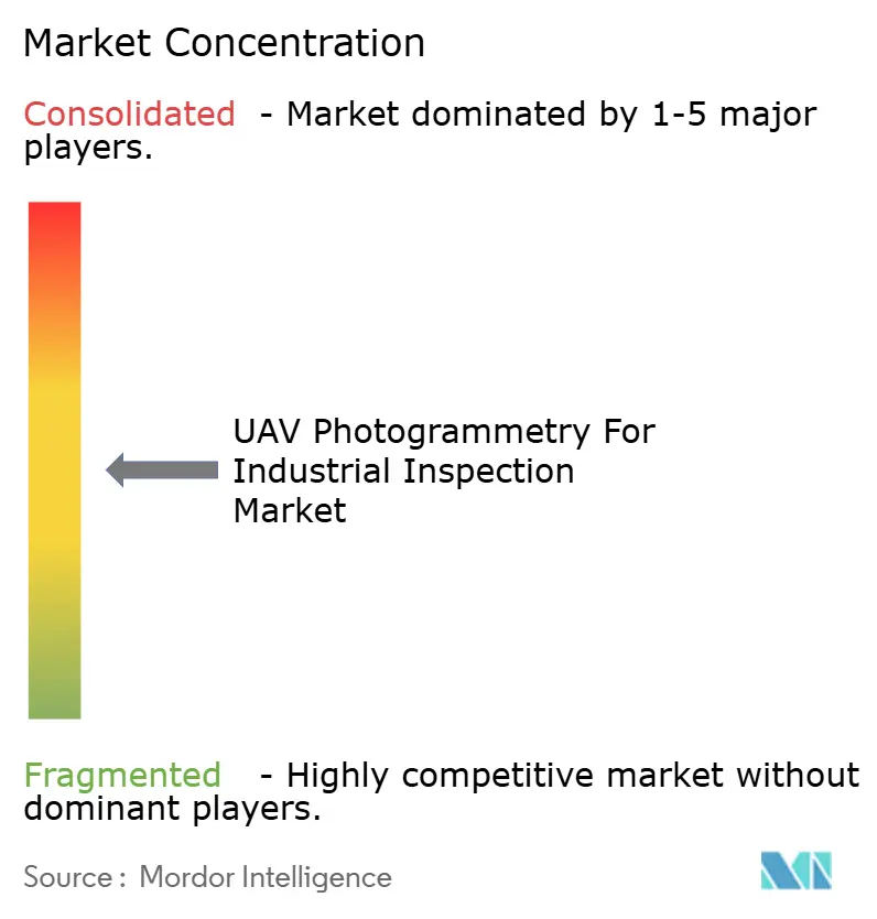
| Market Concentration | Medium |
Major Players *Disclaimer: Major Players sorted in no particular order Image © Mordor Intelligence. Reuse requires attribution under CC BY 4.0. | |
UAV Photogrammetry For Industrial Inspection Market Analysis by Mordor Intelligence
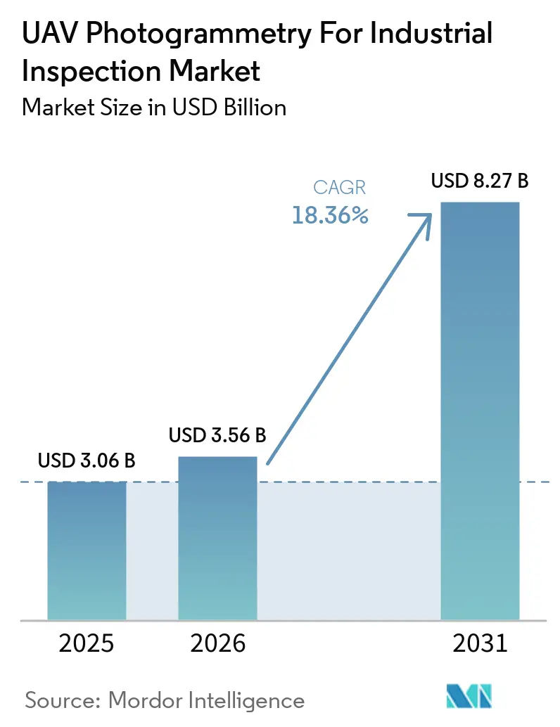
The UAV photogrammetry for industrial inspection market size is projected to expand from USD 3.06 billion in 2025 and USD 3.56 billion in 2026 to USD 8.27 billion by 2031, registering a CAGR of 18.36% between 2026 to 2031. Aging industrial assets are increasing the need for repeatable condition records across infrastructure, utilities, and industrial sites. Renewable energy and transmission construction are also creating recurring inspection work across larger and more dispersed asset networks. AI-enabled processing is shortening the time needed to turn aerial images into usable maintenance information. Suppliers are responding by combining aircraft, sensors, analytics, and visualization in integrated offers. Regulatory consistency for beyond visual line of sight operations and the availability of inspection specialists will shape how quickly operators can scale programs.
Key Report Takeaways
- By solution, hardware held 46.73% of the UAV photogrammetry for industrial inspection market share in 2025, while services are projected to expand at an 18.66% CAGR through 2031.
- By UAV platform, rotary-wing UAVs held 62.84% revenue share in 2025, while hybrid VTOL UAVs are projected to expand at an 18.78% CAGR through 2031.
- By payload category, RGB and high-resolution cameras held 38.67% revenue share in 2025, while multispectral and hyperspectral sensors are projected to expand at an 18.92% CAGR through 2031.
- By end-user industry, energy and utilities held 21.46% revenue share in 2025, while mining is projected to expand at an 18.96% CAGR through 2031.
- By geography, North America held 31.82% of the UAV photogrammetry for industrial inspection market share in 2025, while Asia-Pacific is projected to expand at a 19.11% CAGR through 2031.
Note: Market size and forecast figures in this report are generated using Mordor Intelligence’s proprietary estimation framework, updated with the latest available data and insights as of January 2026.
Global UAV Photogrammetry For Industrial Inspection Market Trends and Insights
Drivers Impact Analysis*
| Driver | (~) % Impact on CAGR Forecast | Geographic Relevance | Impact Timeline |
|---|---|---|---|
| AI-Enabled Defect Detection and Digital Twin Workflows | +4.2% | Global | Short term (≤ 2 years) |
| Aging Industrial Infrastructure Requiring Frequent Condition Assessment | +3.8% | Global, concentrated in North America and Europe | Medium term (2-4 years) |
| Expansion of Renewable Energy and Linear Energy Infrastructure | +3.5% | Global, concentrated in Europe, Asia-Pacific, and North America | Medium term (2-4 years) |
| Safer Remote Inspection of Hazardous and Inaccessible Assets | +2.9% | Global, concentrated in oil and gas and mining | Short term (≤ 2 years) |
| Progress Toward BVLOS and Drone-in-a-Box Operations | +2.4% | North America and Europe, spillover to Asia-Pacific | Medium term (2-4 years) |
| Repeatable Georeferenced Evidence for Compliance and Insurance | +1.8% | North America and Europe, expanding to Asia-Pacific | Long term (≥ 4 years) |
| Source: Mordor Intelligence | |||
AI-Enabled Defect Detection and Digital Twin Workflows
AI classification is changing inspection outputs from image archives into structured records that can support maintenance decisions. The UAV photogrammetry for the industrial inspection market benefits when operators can connect defect observations with existing asset systems. A 2026 study assessed a drone and AI workflow across 10 bridges in Kansas and aligned automated defect counts with nationally reported condition ratings. The work also placed segmented defects into 3D reconstructions for measurement during review. DJI updated FlightHub 2 in August 2026 with Copilot route generation, change detection, and automatic defect tagging.[1]DJI Enterprise Insights, “DJI FlightHub 2 Update, Copilot Route Generation, O4 Ground Station Integration, and a Smarter Analyzer,” DJI, enterprise-insights.dji.com. These features support a workflow in which repeated site visits can produce comparable records for review.
Aging Industrial Infrastructure Requiring Frequent Condition Assessment
Deteriorating civil and industrial assets are moving inspection programs toward more frequent monitoring. UAV photogrammetry for industrial inspection provides repeatable views of structures without relying only on periodic site visits. An ASCE study published in 2026 introduced the RCO-YOLOv5 model for UAV-based defect detection. The model achieved 91.0% mean average precision in the reported field assessment. It also had a 12.8% smaller model size and 6.7% faster inference than its baseline.[2]“Improving Bridge Inspection Performance With an Efficient UAV-Based Automated Defect Detection System,” ASCE Journal of Performance of Constructed Facilities, asce.org. These capabilities support inspection activity where timely structural evidence is needed under field conditions.
Expansion of Renewable Energy and Linear Energy Infrastructure
Wind, solar, and transmission assets require inspection methods that can cover large areas and dispersed equipment. The UAV photogrammetry for the industrial inspection market is supported by the need for faster visual documentation. Recently, the AQUADA-GO consortium completed an autonomous, contact-free inspection of operating offshore wind turbine blades while the turbines continued generating electricity. Subsequently, RES Digital Solutions launched Smart Pilot for wind blade inspection during a turbine stop. It significantly reduced inspection time compared with conventional multi-stop methods on standard DJI hardware. Quantified Energy also inspected 18,125 solar modules at Acciona Energía's 458 MWp Texas facility in June 2026.[3]Quantified Energy, “Quantified Energy Completes First Inverter-Fed EL Inspection on U.S. Soil Via Autonomous Drone Technology,” Quantified Energy, quantified-energy.com.
Safer Remote Inspection of Hazardous and Inaccessible Assets
Pressure vessels, storage tanks, offshore equipment, and underground pipelines can require difficult access arrangements. Remote drone operations reduce the need for personnel to enter hazardous or confined areas during inspection. The UAV photogrammetry for the industrial inspection market, therefore, addresses both data collection and worksite access constraints. Terra Drone introduced a Signal Recovery Feature for Terra Xross 1 in August 2026. The feature was co-developed with Chevron and Shell through the Nippon Foundation and DeepStar consortium. It was designed to reconnect signals in GPS-denied environments and was reported to operate at one-third the cost of conventional indoor inspection platforms.
Restraints Impact Analysis*
| Restraint | (~) % Impact on CAGR Forecast | Geographic Relevance | Impact Timeline |
|---|---|---|---|
| Fragmented BVLOS, Airspace, and Data-Privacy Rules | -3.2% | Global, most acute in North America and the EU | Medium term (2-4 years) |
| Battery Endurance and Payload Trade-Offs | -2.6% | Global | Short term (≤ 2 years) |
| Shortage of Inspection Analysts Combining UAV and Engineering Expertise | -1.9% | Global, most acute in North America | Medium term (2-4 years) |
| Weather, Lighting, and Surface-Condition Sensitivity | -1.2% | Offshore, Northern Europe, and Middle East and Africa | Short term (≤ 2 years) |
| Source: Mordor Intelligence | |||
Fragmented BVLOS, Airspace, and Data-Privacy Rules
Different airspace and privacy requirements can prevent operators from using one standard program across all locations. This remains a material constraint for the UAV photogrammetry for industrial inspection market. The Federal Aviation Administration issued a proposed rule for beyond visual line of sight operations on August 7, 2025. The proposal outlines a Part 108 framework for linear infrastructure inspection and industrial aerial data gathering.[4]Federal Aviation Administration, “Normalizing Unmanned Aircraft Systems Beyond Visual Line of Sight Operations,” Federal Register, federalregister.gov. It was under Office of Information and Regulatory Affairs review in July 2026, with a final rule expected no earlier than late 2026. EASA's STS-01 and STS-02 scenarios replaced national frameworks on January 1, 2026, establishing common competency requirements for relevant flights across EU member states.
Battery Endurance and Payload Trade-Offs
Battery-powered rotary-wing platforms must balance sensor payload weight with productive mission time. Thermal, LiDAR, and encrypted communication payloads can limit usable flight time and require operators to retain battery reserves. The UAV photogrammetry for the industrial inspection market must therefore match aircraft design to the length and type of inspection work. Fixed-wing and hybrid VTOL designs improve endurance through aerodynamic efficiency. They can also require more complex launch and recovery arrangements. Their reduced close-proximity maneuverability limits their fit for confined-structure inspection.
*Our forecasts treat driver/restraint impacts as directional, not additive. The impact forecasts reflect baseline growth, mix effects, and variable interactions.
Segment Analysis
By Solution: Services Are Changing the Revenue Mix
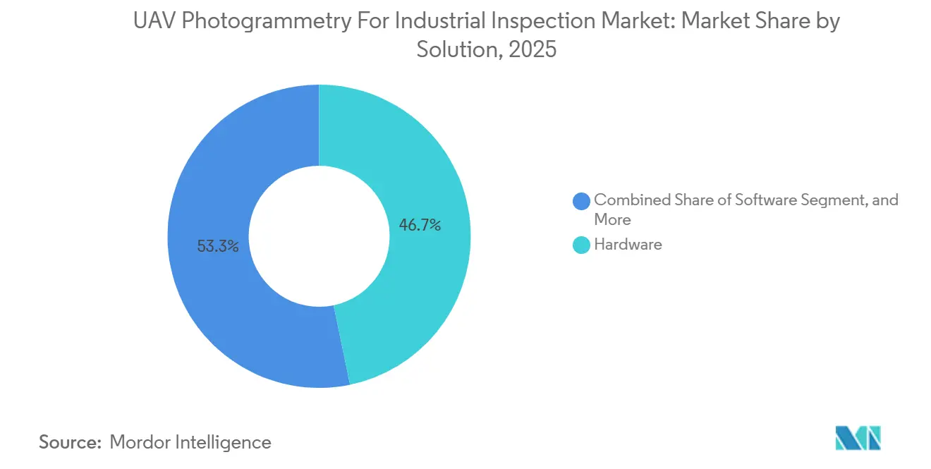
Hardware accounted for 46.73% of the UAV photogrammetry for industrial inspection market size in 2025. This position reflected the capital needed to deploy multi-sensor aircraft across energy, oil and gas, and mining fleets. Asset owners with internal flight programs use hardware control to tailor aircraft and payload configuration to individual sites. Software connects image capture with processing, reporting, and cloud-based review. Integrated capture-to-insight offerings can reduce handoffs between field crews and engineering teams.
Services are projected to expand at an 18.66% CAGR through 2031. Managed offerings address utility and other asset owners that need recurring outcomes without building internal fleets. Pix4D generated substantial photogrammetry revenue in 2025 and reported constant-currency expansion as it shifted toward subscriptions. DroneDeploy processed hundreds of millions of images in 2025 across millions of industrial sites in numerous countries. The UAV photogrammetry for the industrial inspection market is shifting from equipment provision toward recurring asset intelligence services.



By UAV Platform: Hybrid VTOL Gains Ground in Linear Asset Programs
Rotary-wing UAVs held 62.84% of the UAV photogrammetry for industrial inspection market share in 2025. Their vertical takeoff capability, hover precision, and payload flexibility suit turbine, tank, and lattice-tower inspection. These aircraft work well around complex assets that require close visual coverage. Their operating profile is also practical where launch space is limited. In the UAV photogrammetry for industrial inspection market, shorter endurance remains a constraint on long corridor inspections.
Hybrid VTOL UAVs are projected to expand at an 18.78% CAGR through 2031. Their endurance suits transmission lines and pipelines where rotary-wing costs can rise over long distances. Fixed-wing UAVs retain an advantage for large open-pit mines, solar farms, and coastal surveys. Drone Volt signed a contract with Phoenix Tower International to support telecommunications sites across France. Enterprise programs can use all three aircraft types in complementary roles based on asset topology.
By Payload Category: Multispectral Sensors Move into Industrial Diagnostics
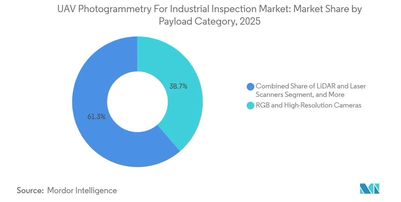
RGB and high-resolution cameras accounted for 38.67% of the UAV photogrammetry for industrial inspection market size in 2025. They provide the visual data used for structural records and 3D reconstruction. Their broad use in the UAV photogrammetry for industrial inspection market reflects the need for a common image source across most inspection workflows. Thermal and infrared cameras form the second-largest payload category. They help identify hotspots in substations, transformers, and process pipelines.
Multispectral and hyperspectral sensors are projected to expand at an 18.92% CAGR through 2031. Spectral analysis can identify coating degradation, corrosion chemistry, and material stress before visible surface damage appears. A recent Scientific Reports study tested combined sensing over an extended trial along a high-voltage transmission right-of-way. It reported very high mean average precision and field precision across identified candidate anomalies. LiDAR, laser scanners, and gas sensors extend inspection capability where point clouds or non-contact emission detection are required.
By End-User Industry: Mining’s Faster Expansion Reflects Geotechnical Oversight
Energy and utilities held 21.46% of the UAV photogrammetry for industrial inspection market share in 2025. Transmission corridors, substations, wind farms, solar arrays, and gas distribution networks create a broad set of inspectable assets. Repeated georeferenced records can support maintenance planning across these systems. Utilities in the UAV photogrammetry for industrial inspection market must also cover assets that are spread across difficult terrain. Renewable generation additions extend the relevant asset base.
Mining is projected to expand at an 18.96% CAGR through 2031. Geotechnical risk management and stockpile reporting are central requirements in this vertical. A recent ISPRS review found that hybrid Structure-from-Motion and AI workflows achieved high horizontal and vertical accuracy. The review also reported low volumetric errors. Construction, engineering, marine, and port users are applying drone-derived point clouds to documentation and survey work.
Geography Analysis
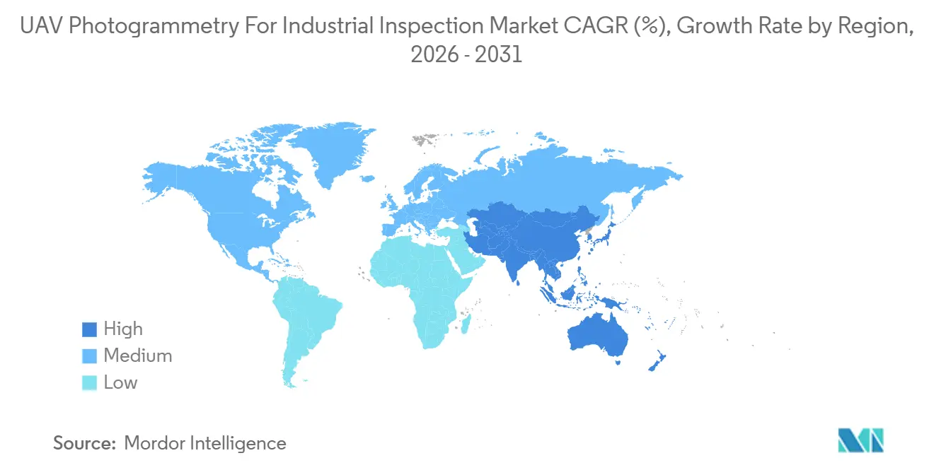
North America held 31.82% of the UAV photogrammetry for industrial inspection market share in 2025. Large utility fleets and established managed-service providers support regional demand. The UAV photogrammetry for the industrial inspection market could benefit if the proposed FAA Part 108 framework reduces compliance burdens after it is finalized. The FCC added DJI and Autel Robotics to its Covered List in December 2025. Skydio announced a USD 3.5 billion, 5-year SkyForge manufacturing commitment in April 2026, targeting more than 2,000 manufacturing jobs.
Asia-Pacific is projected to expand at a 19.11% CAGR through 2031. Solar and wind additions, port investment, offshore development, and regional UAV manufacturing support demand in the UAV photogrammetry for industrial inspection market. China has a large installed base through DJI's enterprise ecosystem. India’s Production Linked Incentive scheme and civil aviation policy updates have supported domestic suppliers such as ideaForge Technology. Japan contributes specialized work in petrochemicals, shipbuilding, and nuclear facilities. Europe’s EASA scenarios offer a more predictable basis for cross-border program design.
The Middle East and Africa has emerging demand in petrochemicals and utilities. Saudi Arabia and the UAE lead adoption through centralized inspection programs linked to digital transformation priorities. Terra Drone secured a pipeline surveillance contract in the Saudi Aramco supply region in 2025. South Africa’s mining operations and Nigeria’s infrastructure needs offer further use cases where access is difficult. Different airspace rules limit adoption outside the Gulf states.

Competitive Landscape
The UAV photogrammetry market for industrial inspection is moderately fragmented. A leading hardware manufacturer controls a significant volume of units. Specialist software, platform, and service providers compete for enterprise programs. Within the UAV photogrammetry for industrial inspection market, vendors differentiate themselves through analytical capabilities, data continuity, and regulatory positioning. Integrated offers connect aircraft, onboard AI, and cloud visualization.
Ondas Inc. recently agreed to acquire Cyberhawk in a substantial transaction. The acquisition brings together Ondas’ autonomous sensing and monitoring capabilities with Cyberhawk’s iHawk platform, its extensive inspection data assets, and its established customer relationships across multiple countries. By combining these capabilities, the transaction aims to strengthen the companies’ ability to meet inspection, monitoring, and asset management requirements across relevant industries. Skydio’s SkyForge commitment similarly reinforces its manufacturing position in alignment with US security policy, which restricts platforms manufactured outside the United States. This approach highlights the growing importance of domestic manufacturing and secure supply chains within the autonomous systems market.
In the UAV photogrammetry for industrial inspection market, hardware manufacturers are adding analytics to retain customer relationships beyond the sale of the aircraft. GPS-denied confined-space inspection remains an opening for Flyability with its LiDAR-guided Elios platform. Drone-in-a-box systems support beyond-visual-line-of-sight monitoring by reducing dependence on on-site operators. The UAV photogrammetry for industrial inspection market presents opportunities for Delair, Drone Volt, Acecore Technologies, and India’s ideaForge, as compliance requirements change vendor qualification processes. Patents in autonomous navigation and AI defect classification remain relevant to long-term positioning.
UAV Photogrammetry For Industrial Inspection Industry Leaders
SZ DJI Technology Co., Ltd.
Pix4D SA
DroneDeploy, Inc.
Terra Drone Corporation
Skydio, Inc.
- *Disclaimer: Major Players sorted in no particular order

Recent Industry Developments
- August 2026: Terra Drone Corporation implemented a "Signal Recovery Feature" for its Terra Xross 1 indoor inspection drone, co-developed with Chevron and Shell through the Nippon Foundation and DeepStar offshore technology consortium. The feature automates signal reconnection in GPS-denied environments at one-third the cost of conventional indoor inspection platforms.
- July 2026: The FAA's proposed Part 108 BVLOS rulemaking arrived at the Office of Information and Regulatory Affairs on July 10, 2026, marking the final substantive gate before Federal Register publication. The rule would replace case-by-case waivers with standardized permits for infrastructure inspection, with full implementation expected 12-18 months after publication.
- July 2026: DJI released Terra software version 5.3.0 on July 27, 2026, adding native thermal 2D reconstruction with integrated temperature measurement, video-based 3D modeling, and an in-app AI assistant for solar farm and utility maintenance inspection.
- June 2026: Ondas Inc. announced a definitive agreement to acquire Cyberhawk for USD 125 million, combining Ondas's autonomous systems with Cyberhawk's iHawk platform and 232+ terabytes of proprietary inspection data across 40 countries. Ondas, Inc. and XPR Newsroom.


Global UAV Photogrammetry For Industrial Inspection Market Report Scope
UAV Photogrammetry for Industrial Inspection Market refers to drone-based aerial surveying and 3D modeling services that use high-resolution RGB (and often thermal/LiDAR) sensors to capture overlapping imagery of industrial assets and convert it into accurate, georeferenced 2D maps and 3D models for condition assessment and asset management.
The UAV Photogrammetry for Industrial Inspection Market Report is Segmented by Solution (Hardware, Software, and Services), Platform (Rotary-Wing, Fixed-Wing, and Hybrid VTOL), Payload (RGB and High-Resolution Cameras, Thermal and Infrared Cameras, LiDAR and Laser Scanners, Multispectral and Hyperspectral Sensors, and Gas and Chemical Sensors), End-User (Energy and Utilities, Oil and Gas, Construction and Engineering, Mining, Industrial Manufacturing, Telecommunications and Towers, Marine, Offshore, and Port, Government and Public Infrastructure, and Other End-User Industries), and Geography (North America, South America, Europe, Asia-Pacific, Middle East and Africa). The Market Forecasts are Provided in Terms of Value (USD).
| Hardware |
| Software |
| Services |
| Aerial Inspection Systems |
| Ground Inspection Robots |
| Underwater and Subsea Inspection Systems |
| Fixed/Stationary Remote Inspection Systems |
| Visual and Video Inspection |
| Thermal and Infrared Inspection |
| 3D/LiDAR and Spatial Inspection |
| NDT and Subsurface Inspection |
| Acoustic and Vibration Inspection |
| Multimodal Fusion Inspection |
| Industrial Manufacturing |
| Oil and Gas |
| Energy and Utilities |
| Infrastructure and Construction |
| Transportation and Marine |
| Aerospace and Defense |
| Mining and Metals |
| Government and Public Safety |
| Inspection, Testing and Certification Service Providers |
| Other End-User Industries |
| North America | United States | |
| Canada | ||
| Mexico | ||
| South America | Brazil | |
| Argentina | ||
| Rest of South America | ||
| Europe | Germany | |
| United Kingdom | ||
| France | ||
| Italy | ||
| Spain | ||
| Rest of Europe | ||
| Asia-Pacific | China | |
| Japan | ||
| India | ||
| South Korea | ||
| ASEAN | ||
| Rest of Asia-Pacific | ||
| Middle East and Africa | Middle East | Saudi Arabia |
| United Arab Emirates | ||
| Turkey | ||
| Rest of the Middle East | ||
| Africa | South Africa | |
| Nigeria | ||
| Rest of Africa | ||
| By Component | Hardware | ||
| Software | |||
| Services | |||
| By Inspection Platform | Aerial Inspection Systems | ||
| Ground Inspection Robots | |||
| Underwater and Subsea Inspection Systems | |||
| Fixed/Stationary Remote Inspection Systems | |||
| By Inspection Capability | Visual and Video Inspection | ||
| Thermal and Infrared Inspection | |||
| 3D/LiDAR and Spatial Inspection | |||
| NDT and Subsurface Inspection | |||
| Acoustic and Vibration Inspection | |||
| Multimodal Fusion Inspection | |||
| By End-User Industry | Industrial Manufacturing | ||
| Oil and Gas | |||
| Energy and Utilities | |||
| Infrastructure and Construction | |||
| Transportation and Marine | |||
| Aerospace and Defense | |||
| Mining and Metals | |||
| Government and Public Safety | |||
| Inspection, Testing and Certification Service Providers | |||
| Other End-User Industries | |||
| By Geography | North America | United States | |
| Canada | |||
| Mexico | |||
| South America | Brazil | ||
| Argentina | |||
| Rest of South America | |||
| Europe | Germany | ||
| United Kingdom | |||
| France | |||
| Italy | |||
| Spain | |||
| Rest of Europe | |||
| Asia-Pacific | China | ||
| Japan | |||
| India | |||
| South Korea | |||
| ASEAN | |||
| Rest of Asia-Pacific | |||
| Middle East and Africa | Middle East | Saudi Arabia | |
| United Arab Emirates | |||
| Turkey | |||
| Rest of the Middle East | |||
| Africa | South Africa | ||
| Nigeria | |||
| Rest of Africa | |||


Key Questions Answered in the Report
What is the UAV photogrammetry for industrial inspection market size?
The market is projected to expand from USD 3.56 billion in 2026 to USD 8.27 billion by 2031 at an 18.36% CAGR.
Which solution is expanding fastest in UAV photogrammetry for industrial inspection?
Services are projected to expand at an 18.66% CAGR through 2031 as asset owners seek managed inspection outcomes.
Which UAV platform has the fastest projected expansion?
Hybrid VTOL UAVs are projected to expand at an 18.78% CAGR through 2031, supported by corridor inspection needs.
Which payload category is projected to expand fastest?
Multispectral and hyperspectral sensors are projected to expand at an 18.92% CAGR through 2031.
Which end-user segment is projected to expand fastest?
Mining is projected to expand at an 18.96% CAGR through 2031 due to geotechnical and volumetric reporting needs.
Which region has the fastest projected expansion?
Asia-Pacific is projected to expand at a 19.11% CAGR through 2031, supported by renewable energy and infrastructure activity.
Page last updated on: