
Terrestrial Laser Scanning For Industrial Facilities Market Size and Share
Market Overview
| Study Period | 2020 - 2031 |
|---|---|
| Market Size (2026) | USD 1.24 Billion |
| Market Size (2031) | USD 1.91 Billion |
| Growth Rate (2026 - 2031) | 9.02 % |
| Fastest Growing Market | Asia-Pacific |
| Largest Market | Asia-Pacific |
| Market Concentration | Medium |
Major Players *Disclaimer: Major Players sorted in no particular order Image © Mordor Intelligence. Reuse requires attribution under CC BY 4.0. | |
Terrestrial Laser Scanning For Industrial Facilities Market Analysis by Mordor Intelligence
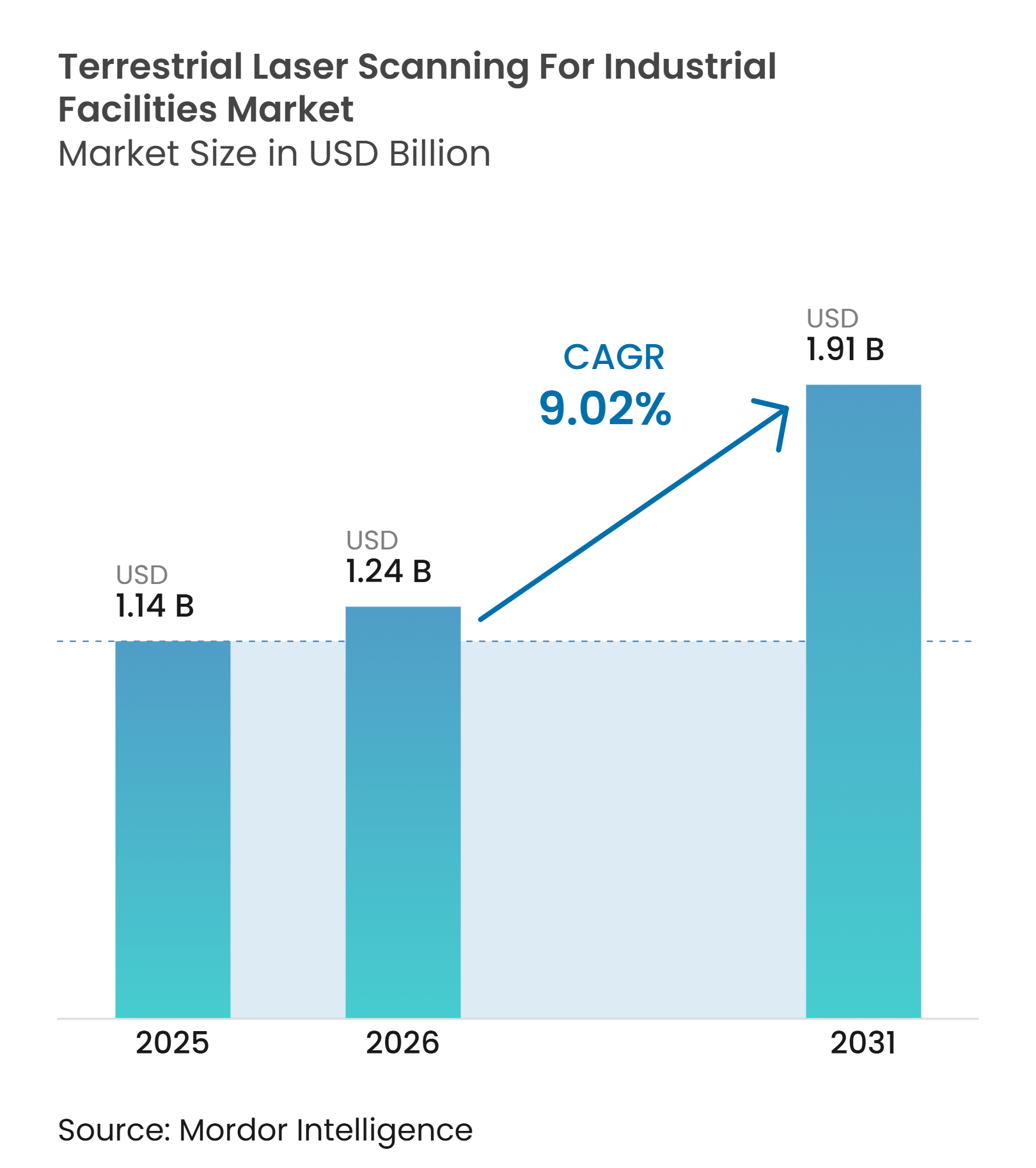
The terrestrial laser scanning for industrial facilities market size was USD 1.14 billion in 2025 and is estimated to grow from USD 1.24 billion in 2026 to reach USD 1.91 billion by 2031, at a CAGR of 9.02% during the forecast period (2026-2031). Industrial operators are making spatial data a routine part of facility maintenance, plant upgrades, and capital planning. Digital-twin programs require accurate as-built records because equipment changes can quickly reduce the value of older facility models. Public building information modeling requirements are also widening the need for reliable point-cloud documentation across several countries. Vendors are responding by linking scanners to cloud platforms and subscription software, which supports recurring revenue beyond equipment sales. Export controls, data-governance requirements, and a shortage of qualified scanning staff may delay some projects, particularly where facilities need high-precision equipment or certified workflows.
Key Report Takeaways
- By product type, static terrestrial laser scanners held 61.83% of the terrestrial laser scanning for industrial facilities market share in 2025, while mobile terrestrial laser scanners are projected to expand at a 10.27% CAGR through 2031.
- By range, mid-range scanners covering 50-200 meters accounted for 44.76% of revenue in 2025, while scanners above 200 meters are expected to grow at a 11.84% CAGR through 2031.
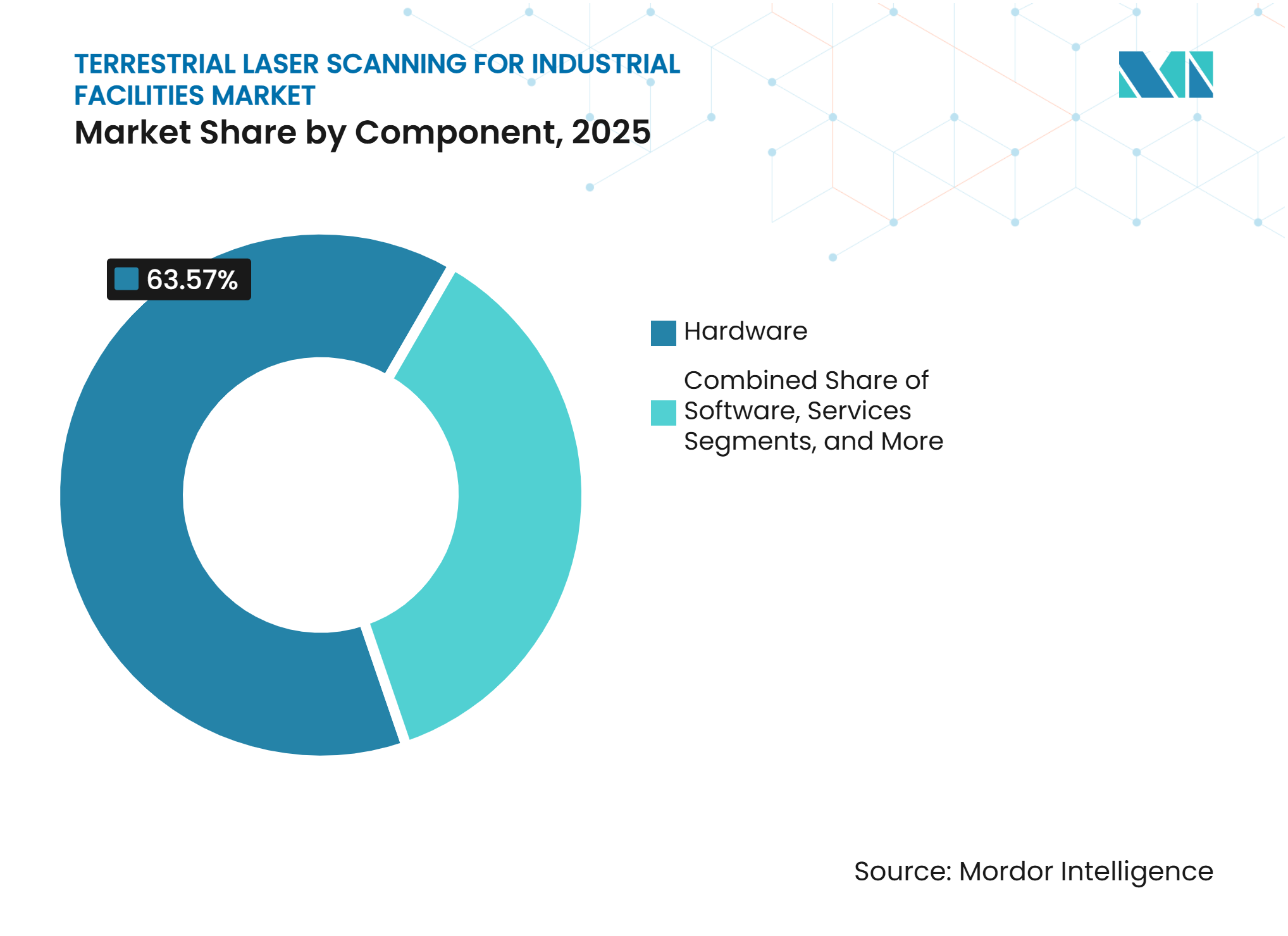
- By component, hardware accounted for 63.57% of revenue in 2025, while software is projected to advance at a 11.43% CAGR through 2031.
- By end-user industry, automotive and industrial manufacturing held 21.64% of revenue in 2025, while warehousing and logistics is forecast to grow at a 11.86% CAGR through 2031.
- By geography, Asia-Pacific held 34.87% of revenue in 2025 and is projected to grow at a 10.47% CAGR through 2031.
Note: Market size and forecast figures in this report are generated using Mordor Intelligence’s proprietary estimation framework, updated with the latest available data and insights as of January 2026.
Market Trends and Insights
Drivers Impact Analysis of Terrestrial Laser Scanning For Industrial Facilities Market*
| Driver | (~) % Impact on CAGR Forecast | Geographic Relevance | Impact Timeline |
|---|---|---|---|
| Industrial Digital-Twin Retrofit Programs | +3.2% | Global, concentrated in North America, Europe, and North Asia | Long term (≥ 4 years) |
| BIM and As-Built Documentation Mandates | +2.0% | Asia-Pacific, Europe, Italy, UK, Hungary, and South America | Medium term (2-4 years) |
| Inspection Automation for Aging Process Assets | +1.8% | North America, Middle East, and Europe | Medium term (2-4 years) |
| Safer Remote Capture in Hazardous Facilities | +1.0% | Middle East, South America, and ATEX-regulated sites globally | Long term (≥ 4 years) |
| AI-Assisted Point-Cloud Classification and Change Detection | +0.9% | Global, with early adoption in China, Japan, and Germany | Medium term (2-4 years) |
| Shorter Shutdown Windows for Brownfield Upgrades | +0.7% | Global, with high value in oil and gas and chemical facilities | Short term (≤ 2 years) |
| Source: Mordor Intelligence | |||
Industrial Digital-Twin Retrofit Programs
Industrial digital-twin programs are creating repeat scanning needs because plant modifications can reduce the accuracy of existing models. Large facilities may need new scan campaigns every 18-36 months as equipment layouts, pipework, and production areas change. This recurrence presents a service opportunity for the terrestrial laser scanning for industrial facilities market alongside equipment demand. NEC launched its Digital Twin Platform for factories and logistics warehouses in March 2025, using visual AI to map operating conditions without manual walkdowns. The Audi FAW new-energy vehicle factory in Changchun used 3D laser cross-scanning with 2D spectral analysis to detect assembly quality at 0.2 millimeters in an automated body shop. Research published in 2026 found that the ACD-IA framework improved multi-temporal terrestrial LiDAR change detection compared with classical geometric methods.
BIM and As-Built Documentation Mandates
Government BIM requirements are making as-built documentation a compliance task for many public construction and facility projects. Terrestrial laser scanning provides point clouds that can support BIM deliverables and more consistent facility records. Malaysia made BIM mandatory from July 1, 2025, for construction and infrastructure projects valued at MYR 10 million (USD 2.1 million) or more. Singapore applied CORENET X requirements to projects above 30,000 square meters from October 1, 2025, and applies the platform to all new projects from October 1, 2026. These requirements can sustain demand for the terrestrial laser scanning for industrial facilities market when private capital spending becomes less certain.
Inspection Automation for Aging Process Assets
Aging process assets require repeated inspection, especially where equipment changes, corrosion risk, or safety exposure create operational concerns. Terrestrial laser scanning can record complex site geometry without requiring personnel to remain close to live equipment for extended periods. This need broadens the terrestrial laser scanning for industrial facilities market across inspection and maintenance contracts. A 2025 study demonstrated an autonomous LiDAR-mapping robot for extra-high-voltage substations that used 3D path planning during inspection work. Equipment designed for explosive atmospheres also supports scan work at petrochemical plants and offshore facilities. The ATEX Directive sets the European Union framework for equipment used in potentially explosive atmospheres.
AI-Assisted Point-Cloud Classification and Change Detection
Point-cloud classification often takes longer than field capture at complex industrial sites, making office processing an important workflow constraint. AI tools are being used to identify objects, classify features, and detect changes in repeated scans. A 2026 Scientific Reports study described an industrial anomaly detection pipeline that produced dense per-point anomaly scores at up to 13.5 frames per second. The Industrial3D dataset included 612 million labeled points at 6-millimeter resolution from 13 water treatment facilities. Its benchmark showed a 39.95-percentage-point difference between the best supervised method and zero-shot foundation models. The result shows why proprietary industrial training data may become an important competitive resource in the terrestrial laser scanning for industrial facilities market.
Restraints Impact Analysis of Terrestrial Laser Scanning For Industrial Facilities Market*
| Restraint | (~) % Impact on CAGR Forecast | Geographic Relevance | Impact Timeline |
|---|---|---|---|
| High Cost of Sensors, Software, and Skilled Integration | -2.5% | Global, most acute in South America, Africa, and Southeast Asia | Long term (≥ 4 years) |
| Point-Cloud Interoperability and Data-Governance Friction | -1.5% | Global | Medium term (2-4 years) |
| Line-of-Sight Occlusion in Dense Plant Environments | -0.9% | Global, especially chemical and petrochemical packed-plant layouts | Medium term (2-4 years) |
| Cybersecurity and Export-Control Constraints on Facility Data | -0.6% | North America, European Union, and Asia-Pacific supply chains | Short term (≤ 2 years) |
| Source: Mordor Intelligence | |||
High Cost of Sensors, Software, and Skilled Integration
A mid-range terrestrial laser scanner costs USD 40,000-70,000, while first-year ownership can exceed USD 120,000 after software, registration tools, and operator labor are included. This spending is burdensome for smaller industrial companies with infrequent scanning needs. The terrestrial laser scanning for industrial facilities market therefore depends in part on service models that reduce upfront commitment. A 2026 study identified financial constraints and technical expertise gaps as leading barriers to 3D scanning adoption among small and medium-sized enterprises. European procurement requirements for CE marking and ISO/IEC 17025 calibration traceability can further increase cost and delivery time. Scanning-as-a-service offers an alternative by allowing a vendor or integrator to provide certified data through an operating expense model.
Point-Cloud Interoperability and Data-Governance Friction
Industrial scan data often moves through proprietary and open formats, including E57, RCP, PTX, and LAS. Transfers between scanner software and design platforms may require middleware licenses or manual conversion, adding time and potentially introducing geometric errors. Interoperability will influence which platforms gain durable positions in the terrestrial laser scanning for industrial facilities market. ISO 19650 provides an information-management framework for BIM across the asset life cycle.[1] The IFC framework also supports open data exchange, although adoption is inconsistent for industrial equipment and piping geometry. Data-control requirements can slow projects that are otherwise positioned as faster digital workflows.
*Our forecasts treat driver/restraint impacts as directional, not additive. The impact forecasts reflect baseline growth, mix effects, and variable interactions.
Terrestrial Laser Scanning For Industrial Facilities Market Segment Analysis
By Product Type:
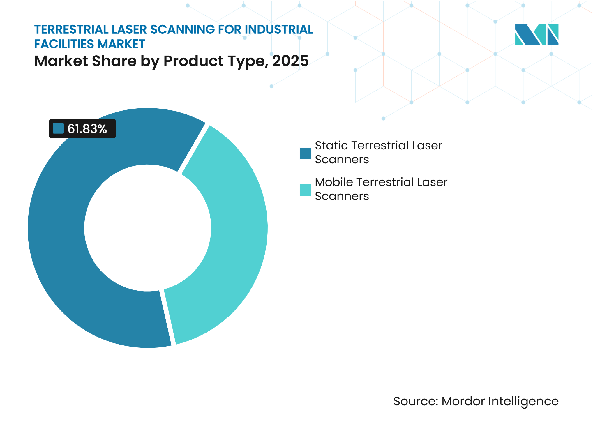
Static Scanners Retain Revenue Leadership While Mobile Platforms Improve Coverage SpeedStatic terrestrial laser scanners accounted for 61.83% of revenue in 2025, the largest share by product type. Facility engineers rely on static systems for detailed brownfield records and high-consequence documentation. Static systems remain central to the terrestrial laser scanning for industrial facilities market because those records need consistent geometric fidelity. Mobile terrestrial laser scanners are projected to grow at a 10.27% CAGR through 2031. Their appeal is strongest where shorter capture campaigns reduce production disruption.
Hybrid workflows combine rapid SLAM-based walks for coverage checks with targeted static scans for geometric fidelity. This balance expands the addressable work for the terrestrial laser scanning for industrial facilities market. Leica Geosystems launched the RTC300, RTC500, and RTC700 series in June 2026, combining ScanStation P-Series accuracy with RTC360 survey speed and Livelink streaming to Hexagon GeoCloud. RIEGL introduced the VZ-1200i in October 2025, with ranges up to 450 meters in high-speed mode for tank farms and LNG terminals.[2] FARO INSIGHT was separated from dimensional metrology activities in January 2026 to focus on reality-capture workflows and cloud connectivity.

By Range:
Mid-Range Systems Serve Common Facility Layouts While Long-Range Demand RisesMid-range scanners with a 50-200-meter range accounted for 44.76% of revenue in 2025. This range meets the usual requirements of chemical units, automotive body shops, and turbine halls. These common layouts continue to anchor unit demand in the terrestrial laser scanning for industrial facilities market. Scanners above 200 meters are expected to expand at an 11.84% CAGR through 2031. Mining, LNG, and open-process facilities need longer stand-off distances around large equipment and hazardous areas.
Short-range scanners remain important in semiconductor fabs and pharmaceutical cleanrooms. Their narrower use cases limit broader penetration across the terrestrial laser scanning for industrial facilities industry. Long-range requirements create specialized demand in the terrestrial laser scanning for industrial facilities market. Topcon launched its CR-P1 scanner at INTERGEO 2025 to enable real-time, georeferenced point cloud generation via its Collage Site workflow. Mining and petrochemical operators are increasingly considering fleet subscriptions instead of isolated project purchases.
By Component:
Hardware Dominates Current Revenue While Software Expands Through SubscriptionsHardware accounted for 63.57% of revenue in 2025 and represented the largest component of the terrestrial laser scanning for industrial facilities market size. First-generation fleet deployment and replacement demand supported this position. These cycles provide an established revenue base for the terrestrial laser scanning for industrial facilities market. Services form the second-largest component, including scanning, registration, BIM conversion, maintenance, and other specialist work. Outsourcing remains relevant for organizations without internal scanning teams.
Software is forecast to grow at an 11.43% CAGR through 2031. Vendors are shifting from perpetual licenses to cloud subscriptions that generate annual contract value for connected systems. This model can increase recurring revenue in the terrestrial laser scanning for industrial facilities market. FARO INSIGHT's Sphere XG platform and Hexagon GeoCloud integration reflect this push toward connected hardware and software ecosystems. A 2026 study found that AI integration and cloud workflow platforms were the 2 leading criteria used by small and medium-sized manufacturers when evaluating 3D scanning software.


By End-User Industry:
Automotive Manufacturing Leads Revenue While Logistics Expands FastestAutomotive and industrial manufacturing held 21.64% of revenue in 2025, the largest end-user revenue share. Assembly plants need accurate as-built data for tooling qualification, line changes, and digital-twin maintenance. The segment remains an important source of demand for the terrestrial laser scanning for industrial facilities market. Electric vehicle conversion adds demand because legacy powertrain spaces must be documented before retrofits begin. Oil and gas, power generation and utilities, and chemical and petrochemical operations formed the second major revenue block.
Warehousing and logistics are projected to record an 11.86% CAGR through 2031. Autonomous mobile robot commissioning requires accurate facility maps, and mobile terrestrial scanning provides a key source of spatial data. This use case extends the terrestrial laser scanning for industrial facilities market beyond conventional process facilities. Operators use repeat scans to monitor rack displacement and aisle changes. Aerospace and defense, pharmaceutical and food processing, and electronics and semiconductor facilities support recurring demand through compliance-oriented scan cycles.
Geography Analysis
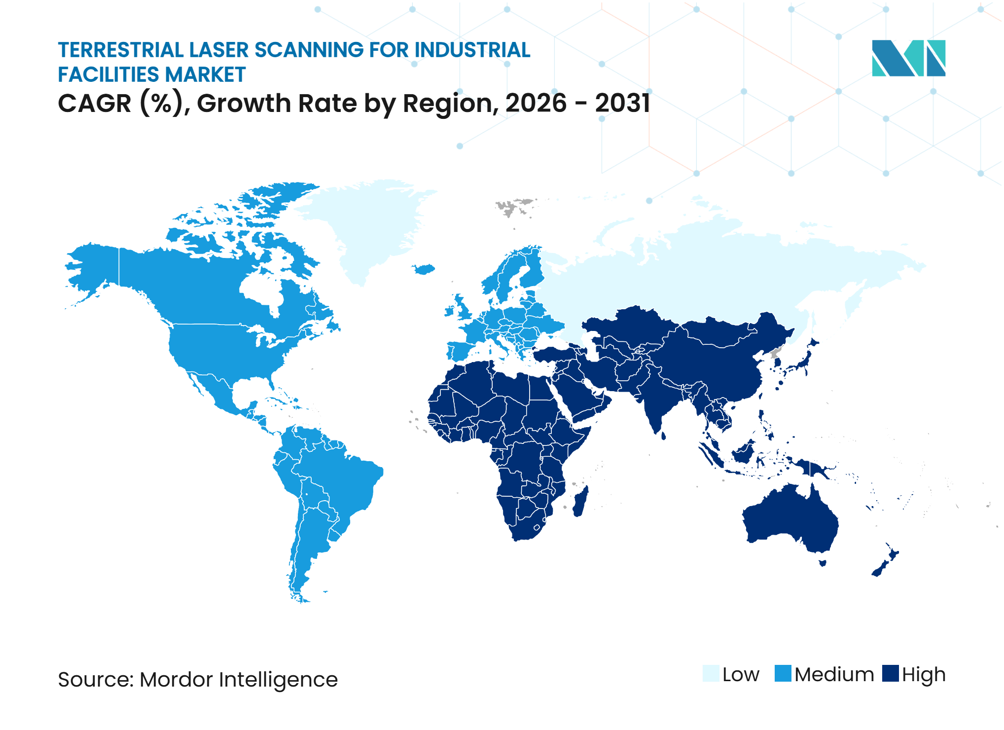
Asia-Pacific held 34.87% of revenue in 2025 and is expected to grow at a 10.47% CAGR through 2031. This gave the region the largest regional revenue share and the fastest regional growth rate. Its scale makes Asia-Pacific central to the terrestrial laser scanning for industrial facilities market. China’s industrial digital transformation programs support a structured demand for point cloud data.[3] The Audi FAW facility demonstrates the use of 3D laser cross-scanning for automated assembly quality work. Japan is using digital twin tools to reduce manual factory walk-downs amid labor shortages. Singapore’s CORENET X and Malaysia’s BIM requirements are adding compliance-driven scanning needs across the region.
North America benefits from aging refineries and chemical facilities, including those along the U.S. Gulf Coast. These assets require repeated scans as modifications accumulate over time. Federal BIM requirements associated with the General Services Administration and the Army Corps of Engineers support public-sector demand. The region remains a mature but important part of the terrestrial laser scanning for industrial facilities market. Europe draws demand from Germany’s manufacturing base, the United Kingdom's infrastructure renewal, and Italy’s BIM rules for public projects. Hungary’s ÉKM Decree 27/2025 extended digital requirements into the facility-management phase from September 2025. Technician shortages reported by 30% of European industrial firms are encouraging greater use of scanning-as-a-service.
The Middle East is supported by industrial diversification in Saudi Arabia and major petrochemical and LNG projects in the UAE and Qatar. Active LNG and refining sites can require ATEX-zone scanning and specialized documentation. Brazil and Chile lead South American demand through offshore oil and gas and Andean mining operations. Limited local technical capacity can constrain growth despite the underlying asset base. South Africa and Egypt lead early adoption in Africa, particularly for mining applications where underground geometry creates a clear operational case.
Competitive Landscape
Market Concentration
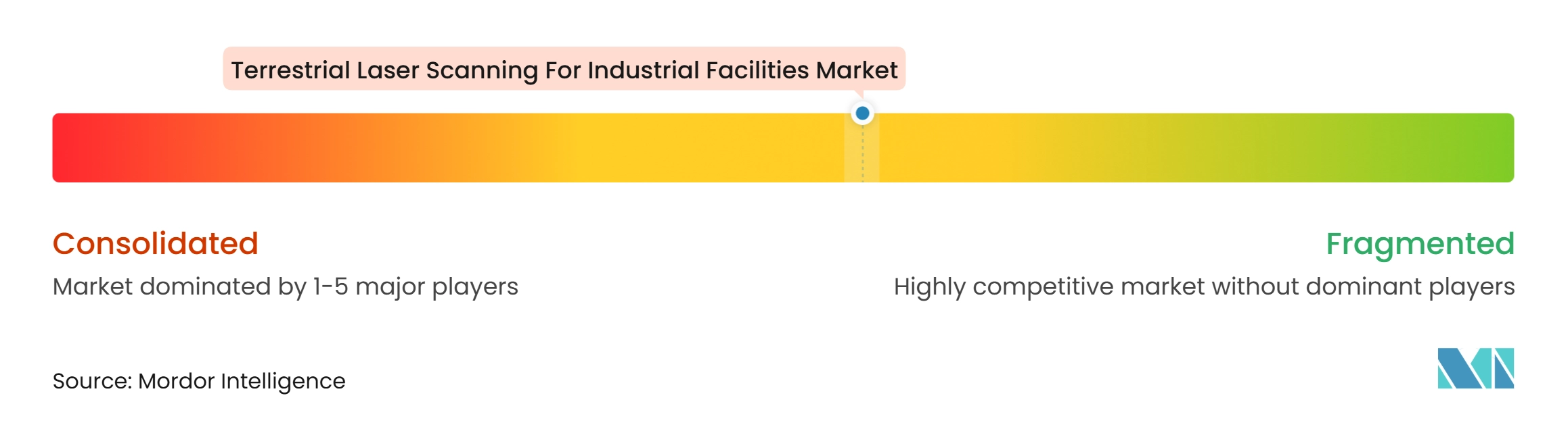
FARO INSIGHT, a business of AMETEK, Leica Geosystems under Hexagon AB, and Trimble lead global hardware and software revenue. The terrestrial laser scanning for industrial facilities market is moderately concentrated among these established suppliers. AMETEK completed its acquisition of FARO Technologies in July 2025 at an enterprise value of USD 920 million.[4] Leica’s June 2026 RTC series release added Livelink streaming to Hexagon GeoCloud and claimed to offer 35% greater data accuracy than the nearest competing product. Topcon’s February 2025 agreement with FARO and its February 2026 CR-S1 release show how alliances and product strategies are being used to compete in mobile capture.
Scanning-as-a-service remains an opportunity for smaller industrial customers who cannot justify owning scanners. Many large suppliers still organize sales around equipment, software, and major-account workflows. ATEX-certified mobile scanning can offer higher project rates in petrochemical and mining work. Only a limited group of suppliers can meet the necessary hardware and operating requirements. AI-native processing platforms are another area of competition. These platforms aim to classify and structure facility data without relying on manual post-processing methods.
Data provenance is also becoming more important for defense and critical-infrastructure applications. FARO received U.S. Patent No. 12278908 in 2025 for a laser-scanner-integrated digital chain-of-custody system. The patent points to growing demand for traceable facility-data handling. Competitive strategies are therefore combining equipment performance, cloud connection, workflow software, and governed data exchange. This direction supports longer customer relationships but raises expectations for interoperability and cybersecurity.
Terrestrial Laser Scanning For Industrial Facilities Industry Leaders
-
FARO Technologies, Inc.
-
Hexagon AB
-
Trimble Inc.
-
Topcon Corporation
-
RIEGL Laser Measurement Systems GmbH
- *Disclaimer: Major Players sorted in no particular order
Terrestrial Laser Scanning For Industrial Facilities Market Companies Covered in this Report
- FARO Technologies, Inc.
- Hexagon AB
- Trimble Inc.
- Topcon Corporation
- RIEGL Laser Measurement Systems GmbH
- Zoller + Fröhlich GmbH
- Surphaser, Inc.
- Teledyne Technologies Incorporated
- Leica Geosystems AG
- Maptek Pty Ltd
- GeoSLAM Ltd
- Nikon Metrology NV
- Carl Zeiss AG
- Creaform Inc.
- Renishaw plc
- Carlson Software Inc.
- 3D Laser Mapping Ltd
Recent Industry Developments in Terrestrial Laser Scanning For Industrial Facilities Market
- June 2026: Leica Geosystems, part of Hexagon AB, launched the Leica RTC300, RTC500, and RTC700 terrestrial laser scanner series on June 9, 2026. The series replaces both the Leica RTC360/LT and ScanStation P-Series lines, introduces Livelink real-time streaming to Hexagon GeoCloud, and is stated to deliver 35% greater data accuracy than the nearest competing product.
- February 2026: Topcon Positioning Systems introduced the CR-S1 handheld scanning system on February 17, 2026, combining LiDAR, panoramic cameras, visual SLAM cameras, and a GNSS antenna in a single device. The CR-S1 targets surveying, tunnel modeling, mining, and industrial plant applications with increased point-cloud density and extended scanning range.
- October 2025: RIEGL Laser Measurement Systems GmbH unveiled the VZ-1200i terrestrial laser scanner at INTERGEO 2025. The Class 1 eye-safe instrument performs a full panoramic scan in 25 seconds at ranges of up to 450 meters in its high-speed measurement program, targeting large petrochemical units, port terminals, and open-process plants.
- October 2025: Topcon Positioning Systems launched the CR-P1 multifunctional 3D terrestrial laser scanner at INTERGEO 2025, enabling real-time, georeferenced point-cloud generation integrated with Topcon Collage Site mass-data workflow software for time-sensitive industrial and construction projects.
Global Terrestrial Laser Scanning For Industrial Facilities Market Report Scope
The Terrestrial Laser Scanning for Industrial Facilities Market refers to the use of ground-based laser scanning technologies to capture highly accurate three-dimensional data of industrial facilities, including manufacturing plants, refineries, power stations, and construction sites. These solutions support applications such as as-built documentation, facility inspection, asset management, engineering design, and maintenance planning by generating detailed digital representations of physical environments.
The Terrestrial Laser Scanning for Industrial Facilities Market Report is Segmented by Product Type (Static Terrestrial Laser Scanners, and Mobile Terrestrial Laser Scanners), Range (Up to 50 Meters, 50-200 Meters, and Above 200 Meters), Component (Hardware, Software, and Services), End-User Industry (Oil and Gas, Power Generation and Utilities, Chemical and Petrochemical, Mining and Mineral Processing, Automotive and Industrial Manufacturing, Aerospace and Defense, Pharmaceutical and Food Processing, Warehousing and Logistics, Research and Institutional Facilities, Electronics and Semiconductor Manufacturing, and Other End-User Industries), and Geography (North America, South America, Europe, Asia-Pacific, Middle East, and Africa). The Market Forecasts are Provided in Terms of Value (USD).
Segmentation Overview
| Static Terrestrial Laser Scanners |
| Mobile Terrestrial Laser Scanners |
| Up to 50 Meters |
| 50-200 Meters |
| Above 200 Meters |
| Hardware |
| Software |
| Services |
| Oil and Gas |
| Power Generation and Utilities |
| Chemical and Petrochemical |
| Mining and Mineral Processing |
| Automotive and Industrial Manufacturing |
| Aerospace and Defense |
| Pharmaceutical and Food Processing |
| Warehousing and Logistics |
| Research and Institutional Facilities |
| Electronics and Semiconductor Manufacturing |
| Other End-User Industries |
| North America | United States |
| Canada | |
| Mexico | |
| South America | Brazil |
| Argentina | |
| Chile | |
| Rest of South America | |
| Europe | Germany |
| United Kingdom | |
| France | |
| Italy | |
| Spain | |
| Rest of Europe | |
| Asia-Pacific | China |
| Japan | |
| India | |
| South Korea | |
| Australia | |
| Rest of Asia-Pacific | |
| Middle East | United Arab Emirates |
| Saudi Arabia | |
| Turkey | |
| Rest of Middle East | |
| Africa | South Africa |
| Egypt | |
| Rest of Africa |
| By Product Type | Static Terrestrial Laser Scanners | |
| Mobile Terrestrial Laser Scanners | ||
| By Range | Up to 50 Meters | |
| 50-200 Meters | ||
| Above 200 Meters | ||
| By Component | Hardware | |
| Software | ||
| Services | ||
| By End-User Industry | Oil and Gas | |
| Power Generation and Utilities | ||
| Chemical and Petrochemical | ||
| Mining and Mineral Processing | ||
| Automotive and Industrial Manufacturing | ||
| Aerospace and Defense | ||
| Pharmaceutical and Food Processing | ||
| Warehousing and Logistics | ||
| Research and Institutional Facilities | ||
| Electronics and Semiconductor Manufacturing | ||
| Other End-User Industries | ||
| By Geography | North America | United States |
| Canada | ||
| Mexico | ||
| South America | Brazil | |
| Argentina | ||
| Chile | ||
| Rest of South America | ||
| Europe | Germany | |
| United Kingdom | ||
| France | ||
| Italy | ||
| Spain | ||
| Rest of Europe | ||
| Asia-Pacific | China | |
| Japan | ||
| India | ||
| South Korea | ||
| Australia | ||
| Rest of Asia-Pacific | ||
| Middle East | United Arab Emirates | |
| Saudi Arabia | ||
| Turkey | ||
| Rest of Middle East | ||
| Africa | South Africa | |
| Egypt | ||
| Rest of Africa | ||
Key Questions Answered in the Report
What is the terrestrial laser scanning for industrial facilities market size?
The market size was USD 1.14 billion in 2025, is estimated at USD 1.24 billion in 2026, and is forecast to reach USD 1.91 billion by 2031 at a 9.02% CAGR.
What is driving adoption of terrestrial laser scanning in industrial facilities?
Digital-twin maintenance, BIM documentation requirements, aging-asset inspection, and safer data capture at hazardous sites are supporting adoption.
Which product type leads industrial facility laser scanning revenue?
Static terrestrial laser scanners led with 61.83% of revenue in 2025, while mobile scanners are forecast to grow faster at a 10.27% CAGR.
Which end-user application is growing fastest through 2031?
Warehousing and logistics is projected to grow at an 11.86% CAGR as operators create accurate maps for autonomous mobile robot fleets.
Which region leads demand for industrial facility laser scanning?
Asia-Pacific held 34.87% of revenue in 2025 and is expected to grow at a 10.47% CAGR through 2031.