
Multispectral LiDAR Systems Market Size and Share
Market Overview
| Study Period | 2020 - 2031 |
|---|---|
| Market Size (2026) | USD 1.22 Billion |
| Market Size (2031) | USD 2.86 Billion |
| Growth Rate (2026 - 2031) | 18.58 % |
| Fastest Growing Market | Asia-Pacific |
| Largest Market | North America |
| Market Concentration | Medium |
Major Players *Disclaimer: Major Players sorted in no particular order Image © Mordor Intelligence. Reuse requires attribution under CC BY 4.0. | |
Multispectral LiDAR Systems Market Analysis by Mordor Intelligence
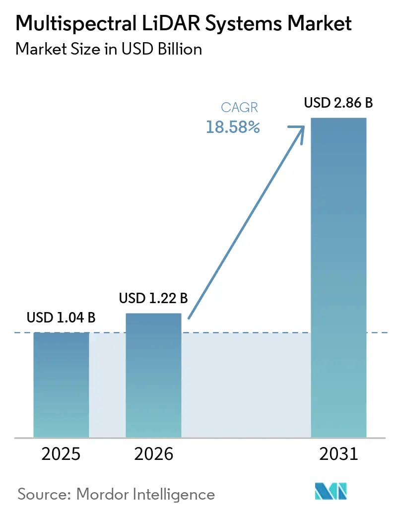
The Multispectral LiDAR Systems Market size is projected to expand from USD 1.04 billion in 2025 to USD 1.22 billion in 2026, and to USD 2.86 billion by 2031, registering a CAGR of 18.58% between 2026 and 2031. Demand reflects the need to capture both precise 3D geometry and material reflectance in a single survey. This approach eliminates the need for separate instruments, flight windows, and manual alignment across many assignments. Procurement decisions increasingly consider lower mobilization requirements and fewer repeat missions. Coastal mapping, forest monitoring, automation, and infrastructure surveys support a broader base of demand for the Multispectral LiDAR Systems Market. Cost, calibration requirements, and limited public training data remain barriers, particularly for smaller operators.
Key Report Takeaways
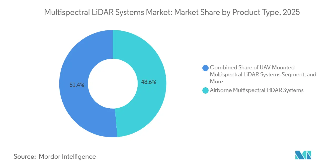
- By product type, airborne systems held 48.63% of the Multispectral LiDAR Systems Market share in 2025, while UAV-mounted systems are projected to expand at a 19.83% CAGR through 2031.
- By wavelength configuration, green and NIR systems held 39.47% revenue share in 2025, while NIR and SWIR systems are projected to expand at a 19.67% CAGR through 2031.
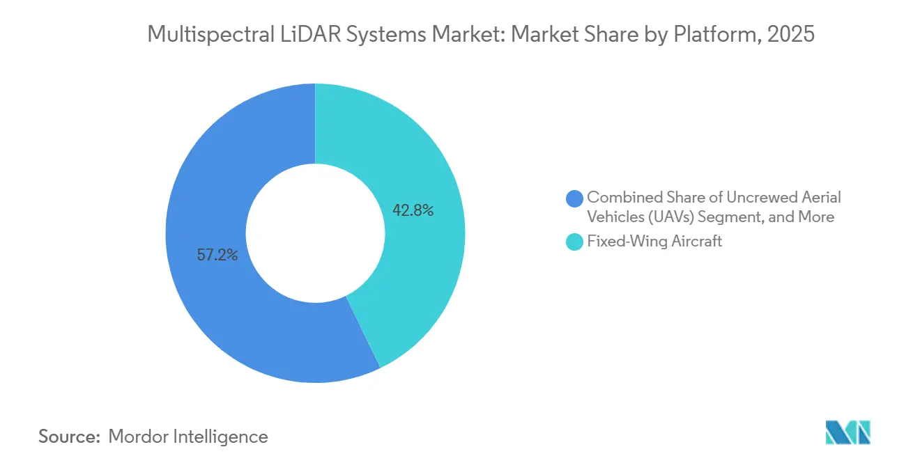
- By platform, fixed-wing aircraft held 42.83% Multispectral LiDAR Systems Market revenue share in 2025, while UAVs are projected to expand at a 19.43% CAGR through 2031.
- By end-user industry, government and defense agencies held 24.73% revenue share in 2025, while automotive is projected to expand at an 18.93% CAGR through 2031.
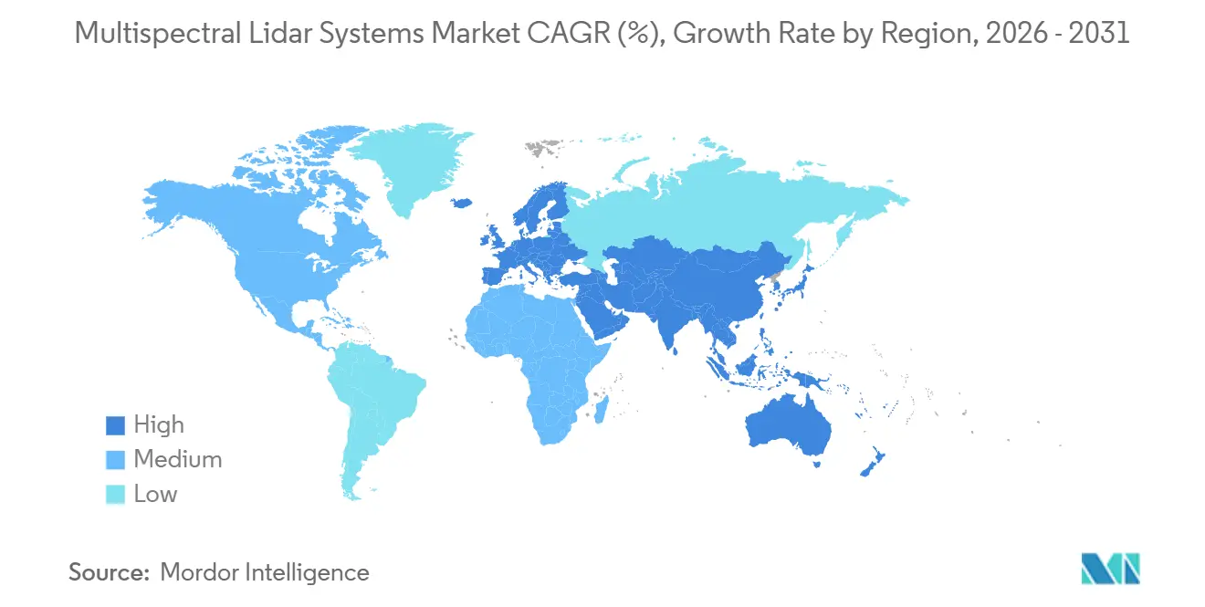
- By geography, North America held a 34.67% revenue share in the Multispectral LiDAR Systems Market in 2025, while Asia-Pacific is projected to expand at a 19.87% CAGR through 2031.
Note: Market size and forecast figures in this report are generated using Mordor Intelligence’s proprietary estimation framework, updated with the latest available data and insights as of January 2026.
Global Multispectral LiDAR Systems Market Trends and Insights
Drivers Impact Analysis*
| Driver | (~) % Impact on CAGR Forecast | Geographic Relevance | Impact Timeline |
|---|---|---|---|
| Simultaneous 3D Structure and Spectral Classification | +4.1% | Global | Medium term (2-4 years) |
| Coastal, Inland-Water, and Topo-Bathymetric Mapping | +3.2% | North America and Europe, with spillover to Asia-Pacific | Short term (≤ 2 years) |
| Precision Forestry and Natural-Resource Monitoring | +2.6% | Europe, North America, and Asia-Pacific | Medium term (2-4 years) |
| One-Flight Data Fusion | +2.4% | Global | Short term (≤ 2 years) |
| Material-Aware Automation in Mining, Quarries, and Biomass Handling | +2.0% | Asia-Pacific, with spillover to Middle East and Africa | Long term (≥ 4 years) |
| AI Training Demand for Co-Registered Point Clouds | +2.8% | North America and Europe | Medium term (2-4 years) |
| Source: Mordor Intelligence | |||
Demand for Simultaneous 3D Structure and Spectral Classification
Passive imagery and single-wavelength LiDAR can struggle to distinguish objects with similar shapes but different materials. Asphalt, moist soil, and grass can have comparable geometric profiles while showing different NIR and SWIR reflectance. Multispectral systems capture these structural and spectral signals in the same pass. A 2025 study reported improved urban scene classification from co-registered multispectral point clouds when compared with single-band baselines.[1]P. Li et al., “Masking Graph Cross-Convolution Network for Multispectral Point Cloud Classification,” IEEE Transactions on Geoscience and Remote Sensing, ieee.org This capability supports the use of material labels in downstream robotics and sorting workflows. The Multispectral LiDAR Systems Market benefits when classification needs are as important as spatial measurement, particularly when operators need results from a single coordinated collection process.
Growth in Coastal, Inland-Water, and Topo-Bathymetric Mapping
National mapping programs provide a steady source of demand for topo-bathymetric systems. These programs generally use multiyear procurement cycles, which can reduce sensitivity to short-term commercial survey budgets. Teledyne Geospatial introduced Fathom in February 2025 with a 2,000,000 points/sec topographic channel, a green bathymetric channel, and a 120 MP RGB and NIR camera.[2]Teledyne Optech, “Teledyne Geospatial Announces Fathom,” Teledyne Optech, teledyneoptech.com Leica Geosystems introduced CoastalMapper in February 2025, capable of collecting 1 million bathymetric and 2 million topographic points/second, covering 360 km²/hr. These releases made integrated coastal mapping systems more accessible as standard products within the Multispectral LiDAR Systems Market. NOAA’s coastal topobathy data program and the U.S. Army Corps of Engineers continue to support demand for green and NIR configurations.[3]Leica Geosystems, “New Leica CoastalMapper LiDAR Sensor Significantly Speeds Up Airborne Bathymetric Mapping,” Leica Geosystems, leica-geosystems.com
Expansion of Precision Forestry and Natural-Resource Monitoring
A 2024 review found that forestry accounted for 42.7% of published multispectral LiDAR research. Commercial uptake has lagged research, but forest agencies increasingly need species classification, root-rot detection, and biomass estimates. A 2025 study identified spectral and structural differences between healthy and root rot-infected Norway spruce trees across 110 classified trees. The ForestSemantic-MS dataset, released in December 2025, provided annotated forest point clouds across 6 components for semantic segmentation work. More usable training data can lower analysis costs for forestry operators and carbon-credit verification work. These conditions broaden the relevance of the Multispectral LiDAR Systems Market beyond public forest services and enable commercial operators to assess vegetation at the stand scale.
One-Flight Data Fusion Reducing Repeat Missions and Registration Error
Single-pass acquisition helps commercial service providers reduce the need for repeat flights and mobilization time. It also avoids alignment errors that can arise when imagery and LiDAR are collected separately. Those errors can affect classification at canopy edges, shorelines, and other object boundaries. Teledyne Optech’s Stratus system, paired with a Phase One 4-band payload, captures LiDAR and multispectral data simultaneously at up to 2 million points/sec. A 2026 study validated a backpack system that combined LiDAR and 4-band multispectral data into a georeferenced 3D scene without a separate calibration step.[4]C. Sothe et al., “Integrating Multispectral Imagery with Lidar Enhances 3D Mobile Mapping of Vegetation Condition,” PFG - Journal of Photogrammetry, Remote Sensing and Geoinformation Science, springer.com The Multispectral LiDAR Systems Market can apply this operational benefit to both mobile and airborne work.
Restraints Impact Analysis*
| Restraint | (~) % Impact on CAGR Forecast | Geographic Relevance | Impact Timeline |
|---|---|---|---|
| High Acquisition, Calibration, and Processing Cost | -2.9% | Global, most acute in South America and Middle East and Africa | Short term (≤ 2 years) |
| Limited Benchmark Datasets and Ground Truth | -1.8% | Global | Medium term (2-4 years) |
| Cross-Channel Co-Registration and Radiometric Drift in Operational Fleets | -1.5% | North America and Europe | Medium term (2-4 years) |
| Spectral-Band Selection Lock-In and Workflow Fragmentation | -1.0% | Global | Long term (≥ 4 years) |
| Source: Mordor Intelligence | |||
High Acquisition, Calibration, and Processing Cost
Multispectral LiDAR systems require proprietary optical designs, multichannel detectors, and wavelength-specific calibration. These features make their acquisition cost higher than that of single-wavelength platforms. Project operators may struggle to spread this cost across assignments that do not need material classification. Processing also requires more computing capacity and specialized skills because the point clouds contain multiple registered channels. Nonstandard radiometric correction workflows can increase operating complexity. The constraint is strongest in South America and Middle East, and Africa, where import duties and limited calibration capacity can increase the total cost of ownership for participants in the Multispectral LiDAR Systems Market.
Limited Benchmark Datasets and Ground Truth
Publicly available annotated datasets remain limited for multispectral LiDAR applications. The FGI-EMIT dataset includes 1,561 manually annotated trees across 3 wavelengths, while the RIEGL-ISPRS Loosdorf-Melk dataset addresses 25 urban classification classes. Dataset development has not kept pace with model development. Vendors may need to create proprietary training data, increasing project budgets and contract timelines. EuroSDR and ISPRS have coordinated benchmark activity, but scale and spectral diversity remain constrained. This limits the adoption of Multispectral LiDAR Systems among service providers without dedicated data development resources.
*Our forecasts treat driver/restraint impacts as directional, not additive. The impact forecasts reflect baseline growth, mix effects, and variable interactions.
Segment Analysis
By Product Type: Airborne Systems Lead While UAV Platforms Expand Access
Airborne systems held 48.63% of the product-type segment in 2025. Their position reflects operational range, payload capacity, and a long procurement history. Fixed-wing aircraft and helicopters remain suitable for coastal surveys and large forestry assignments. These missions benefit from endurance and the ability to carry several sensors.
UAV-mounted systems are projected to expand at a 19.83% CAGR from 2026 to 2031. Lower payload weight can reduce cost per hectare for forestry and mine-site teams. RIEGL presented the miniVUX-4UAV at INTERGEO 2026, featuring up to 400 kHz operation and 12 mm accuracy on a platform below 1 kg. Terrestrial systems remain focused on geological outcrops and industrial stockpiles, while mobile systems support highway and port applications. The Multispectral LiDAR Systems Industry continues to experience a product gap between academic mobile prototypes and standard commercial catalogs, leaving an opening in the Multispectral LiDAR Systems Market.



By Wavelength Configuration: Green and NIR Support Mapping While NIR and SWIR Gain Uses
Green and NIR configurations accounted for 39.47% of the Multispectral LiDAR Systems Market in 2025. The 532 nm green and 1,064 nm NIR pairing supports bathymetry and topographic intensity contrast. This pairing remains central to coastal and vegetation mapping. National hydrographic programs continue to favor this configuration for water and terrain surveys.
NIR and SWIR configurations are projected to expand at a 19.67% CAGR through 2031. Automotive perception and ore sorting benefit from their additional material specificity. IEC 60825-1 eye-safety requirements also influence the use of longer wavelengths in some industrial and military applications. Green, NIR, and SWIR triband systems bridge the gap between established 2-channel products and multiband designs. Tunable and broadband systems remain largely at the prototype stage, although research in 2026 showed continued work on photonic LiDAR architectures. These architecture choices affect product development within the Multispectral LiDAR Systems Market.
By Platform: Fixed-Wing Aircraft Retain Scale While UAVs Gain Ground
Fixed-wing aircraft held 42.83% of the platform segment in 2025. They provide efficient coverage for government agencies that manage national coastal, forestry, and infrastructure baselines. Fathom and CoastalMapper were introduced for fixed-wing work in February 2025. CoastalMapper was designed for both fixed-wing and helicopter survey operations.
UAVs are projected to expand at a 19.43% CAGR from 2026 to 2031. Compact payloads and compliant drone hardware support their use in professional surveying. Helicopters remain relevant where terrain or offshore assets require maneuverability. Ground vehicles and industrial machines support port logistics and conveyor-belt classification. RIEGL presented the VUX-3HA at INTERGEO 2026, featuring a 3 MHz effective measurement rate to support kinematic applications. These platform choices widen the operational reach of the Multispectral LiDAR Systems Market.
By End-User Industry: Government and Defense Provide Demand While Automotive Advances
Government and defense agencies accounted for 24.73% of the end-user segment in 2025. Their purchases support terrain intelligence, coastal mapping, and national baseline data programs. Some defense-related activity is not visible in commercial sales reporting. Interagency data sharing can also transfer capability without recording a direct commercial sale.
The automotive industry is projected to expand at an 18.93% CAGR through 2031. Autonomous systems need to distinguish materials and road conditions that single-channel LiDAR may not separate. MicroVision announced in September 2026 that its 1,550 nm IRIS long-range LiDAR was selected for autonomous heavy military ground vehicles. Surveying, mapping, utilities, forestry, and industrial robotics remain relevant buyer groups for the Multispectral LiDAR Systems Market. RIEGL’s VQ-1060 combines high-density LiDAR with multispectral imaging for corridor mapping and vegetation work.
Geography Analysis
North America held 34.67% of the Multispectral LiDAR Systems Market share in 2025. NOAA, the U.S. Army Corps of Engineers, and the U.S. Geological Survey support demand for coastal and topographic mapping. Canada adds demand from natural-resource inventory and forest carbon accounting. Mexico remains at an earlier stage, with activity concentrated in infrastructure corridor mapping. The February 2025 launches of Fathom and CoastalMapper were directed toward North American coastal survey requirements.
Asia-Pacific is projected to expand at a 19.87% CAGR between 2026 and 2031. China’s autonomous vehicle programs and demand for drone-based infrastructure inspection support in the region. India’s National Infrastructure Pipeline supports the mapping needs of highways, railways, and water bodies. Japan’s aging civil engineering workforce strengthens the case for automated drone survey methods. Compact UAV sensors are positioned for commercial survey firms that need lower-cost access to the Multispectral LiDAR Systems Market.
Europe had a meaningful presence in 2025, led by Germany, the United Kingdom, and France. Finland and Sweden have extensive operational experience with multispectral airborne LiDAR, including work with the Finnish Geospatial Research Institute’s HeliALS system. Hexagon acquired ITRES in June 2026, bringing airborne hyperspectral and thermal imaging capabilities into its Leica geospatial portfolio. South America offers potential in Amazon monitoring and precision agriculture but faces duties and calibration constraints, while the Middle East and Africa remain in an early adoption stage, with demand tied mainly to defense, oil and gas, and pipeline mapping projects in the Multispectral LiDAR Systems Market.

Competitive Landscape
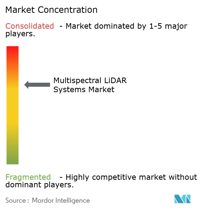
The Multispectral LiDAR Systems Market is moderately concentrated among Teledyne Optech, RIEGL Laser Measurement Systems, and Hexagon. These companies compete through integrated sensor configurations, point rates, spectral channels, and camera payloads. Software that converts raw multichannel data into usable classifications is also important. Buyers consider both sensor performance and the time required to deliver final data products.
RIEGL introduced the VQ-1060 at INTERGEO 2025 in Frankfurt. The system combines multidirectional 3D LiDAR, oblique RGB imagery, and nadir multispectral imaging for corridor inspection and vegetation monitoring. Teledyne Geospatial launched Fathom in February 2025 as an integrated topographic, bathymetric, RGB, and NIR system. Hexagon’s June 2026 acquisition of ITRES added hyperspectral airborne imaging to its Leica LiDAR hardware ecosystem.
Opportunities remain in compact terrestrial and mobile equipment for forestry and industrial users. Cloud-based processing platforms can reduce the specialist skills needed to prepare labeled point clouds. Outsight and IRIDESENSE are among the challengers working on sensor-level AI inference for automotive and compact spectral LiDAR use cases. A 2026 Nature Communications paper demonstrated chip-level, polarization-resolved material classification at the nanosecond scale. Professional drone operators also consider airspace rules when selecting UAV-mounted systems. This keeps compliance and practical deployment requirements central to competition in the Multispectral LiDAR Systems
Multispectral LiDAR Systems Industry Leaders
Teledyne Optech Incorporated
RIEGL Laser Measurement Systems GmbH
Hexagon AB
Outsight SA
Headwall Photonics, Inc.
- *Disclaimer: Major Players sorted in no particular order

Recent Industry Developments
- September 2026: RIEGL presented the miniVUX-4UAV, up to 400 kHz and 12 mm accuracy, and the VUX-3HA, 3 MHz measurement rate, at INTERGEO 2026 in Munich, expanding UAV and kinematic multispectral LiDAR performance at compact form factors for forestry, corridor, and infrastructure applications.
- September 2026: MicroVision announced its IRIS long-range LiDAR sensor, 1,550 nm, solid-state, and invisible to night-vision goggles, was selected for autonomous heavy military ground vehicles, signaling converging defense and commercial LiDAR technology roadmaps.
- June 2026: Hexagon AB acquired ITRES Research Limited, a Calgary-based airborne hyperspectral and thermal imaging provider expected to generate EUR 13 million (USD 14.2 million), in 2026 revenue, adding hyperspectral airborne imaging to its Leica LiDAR hardware portfolio.
- October 2025: RIEGL unveiled the VQ-1060 at INTERGEO 2025 in Frankfurt, integrating multidirectional 3D LiDAR, oblique RGB, and nadir multispectral imaging in a single aerial system for utility corridor inspection and vegetation encroachment analysis.


Global Multispectral LiDAR Systems Market Report Scope
Multispectral LiDAR Systems are advanced remote sensing devices that combine precise distance measurement with spectral data acquisition across multiple wavelengths, enabling the simultaneous capture of 3D spatial geometry and material-specific reflectance signatures for enhanced object classification, vegetation health analysis, and detailed environmental mapping.
The Multispectral LiDAR Systems Market Report is Segmented by Product Type (Airborne Multispectral LiDAR Systems, UAV-Mounted Multispectral LiDAR Systems, Terrestrial Multispectral LiDAR Systems, and Mobile and Vehicle-Mounted Multispectral LiDAR Systems), Wavelength Configuration (Green + Near-Infrared (NIR), Green + NIR + Short-Wave Infrared (SWIR), NIR + SWIR, Multiband and Four-or-More Discrete Wavelengths, and Tunable and Broadband Spectral LiDAR), Platform (Fixed-Wing Aircraft, Helicopters, Uncrewed Aerial Vehicles (UAVs), Ground Vehicles and Industrial Machines, and Tripod, Gantry, and Laboratory Platforms), End-User Industry (Government and Defense Agencies, Surveying, Mapping, and Geospatial Service Providers, Engineering, Construction, and Infrastructure (AEC) Firms, Utilities, Energy, and Power Operators, Mining and Extractive Industry Operators, Agriculture and Forestry Operators, Environmental, Conservation, and Natural-Resource Organizations, Research Institutions and Universities, Automotive, Industrial Robotics, and Other End-User Industries), and Geography (North America, South America, Europe, Asia-Pacific, Middle East and Africa). The Market Forecasts are Provided in Terms of Value (USD).
| Airborne Multispectral LiDAR Systems |
| UAV-Mounted Multispectral LiDAR Systems |
| Terrestrial Multispectral LiDAR Systems |
| Mobile and Vehicle-Mounted Multispectral LiDAR Systems |
| Green + Near-Infrared (NIR) |
| Green + NIR + Short-Wave Infrared (SWIR) |
| NIR + SWIR |
| Multiband and Four-or-More Discrete Wavelengths |
| Tunable and Broadband Spectral LiDAR |
| Fixed-Wing Aircraft |
| Helicopters |
| Uncrewed Aerial Vehicles (UAVs) |
| Ground Vehicles and Industrial Machines |
| Tripod, Gantry, and Laboratory Platforms |
| Government and Defense Agencies |
| Surveying, Mapping, and Geospatial Service Providers |
| Engineering, Construction, and Infrastructure (AEC) Firms |
| Utilities, Energy, and Power Operators |
| Mining and Extractive Industry Operators |
| Agriculture and Forestry Operators |
| Environmental, Conservation, and Natural-Resource Organizations |
| Research Institutions and Universities |
| Automotive |
| Industrial Robotics |
| Other End-User Industries |
| North America | United States | |
| Canada | ||
| Mexico | ||
| South America | Brazil | |
| Argentina | ||
| Rest of South America | ||
| Europe | Germany | |
| United Kingdom | ||
| France | ||
| Italy | ||
| Spain | ||
| Rest of Europe | ||
| Asia-Pacific | China | |
| Japan | ||
| India | ||
| South Korea | ||
| Rest of Asia-Pacific | ||
| Middle East and Africa | Middle East | Saudi Arabia |
| United Arab Emirates | ||
| Turkey | ||
| Rest of the Middle East | ||
| Africa | South Africa | |
| Nigeria | ||
| Rest of Africa | ||
| By Product Type | Airborne Multispectral LiDAR Systems | ||
| UAV-Mounted Multispectral LiDAR Systems | |||
| Terrestrial Multispectral LiDAR Systems | |||
| Mobile and Vehicle-Mounted Multispectral LiDAR Systems | |||
| By Wavelength Configuration | Green + Near-Infrared (NIR) | ||
| Green + NIR + Short-Wave Infrared (SWIR) | |||
| NIR + SWIR | |||
| Multiband and Four-or-More Discrete Wavelengths | |||
| Tunable and Broadband Spectral LiDAR | |||
| By Platform | Fixed-Wing Aircraft | ||
| Helicopters | |||
| Uncrewed Aerial Vehicles (UAVs) | |||
| Ground Vehicles and Industrial Machines | |||
| Tripod, Gantry, and Laboratory Platforms | |||
| By End-User Industry | Government and Defense Agencies | ||
| Surveying, Mapping, and Geospatial Service Providers | |||
| Engineering, Construction, and Infrastructure (AEC) Firms | |||
| Utilities, Energy, and Power Operators | |||
| Mining and Extractive Industry Operators | |||
| Agriculture and Forestry Operators | |||
| Environmental, Conservation, and Natural-Resource Organizations | |||
| Research Institutions and Universities | |||
| Automotive | |||
| Industrial Robotics | |||
| Other End-User Industries | |||
| By Geography | North America | United States | |
| Canada | |||
| Mexico | |||
| South America | Brazil | ||
| Argentina | |||
| Rest of South America | |||
| Europe | Germany | ||
| United Kingdom | |||
| France | |||
| Italy | |||
| Spain | |||
| Rest of Europe | |||
| Asia-Pacific | China | ||
| Japan | |||
| India | |||
| South Korea | |||
| Rest of Asia-Pacific | |||
| Middle East and Africa | Middle East | Saudi Arabia | |
| United Arab Emirates | |||
| Turkey | |||
| Rest of the Middle East | |||
| Africa | South Africa | ||
| Nigeria | |||
| Rest of Africa | |||


Key Questions Answered in the Report
What is the size of the Multispectral LiDAR Systems Market?
The Multispectral LiDAR Systems Market was USD 1.22 billion in 2026 and is projected to reach USD 2.86 billion by 2031 at an 18.58% CAGR.
Which product type leads demand?
Airborne systems led with 48.63% share in 2025, supported by their range, payload capacity, and use in large-area surveys.
Which platform is expected to expand fastest?
UAVs are projected to expand at a 19.43% CAGR through 2031, supported by compact payloads and professional survey use.
Why are green and NIR configurations widely used?
Green and NIR systems held 39.47% share in 2025 because they support water penetration for bathymetry and topographic contrast.
Which region has the fastest outlook?
Asia-Pacific is projected to expand at a 19.87% CAGR through 2031, supported by infrastructure, drone, and automotive programs.
What limits adoption of multispectral LiDAR systems?
High equipment, calibration, and processing costs, along with limited annotated benchmark datasets, remain the principal barriers.
Page last updated on:


 Your data is secure and never sold or shared.