
Market Overview
| Study Period | 2020 - 2031 |
|---|---|
| Forecast Data Period | 2026 - 2031 |
| Base Year Market Size (2025) | USD 142.35 Million |
| Market Size (2026) | USD 159.14 Million |
| Market Size (2031) | USD 321.73 Million |
| Growth Rate (2026 - 2031) | 15.12 % |
| Market Concentration | Medium |
Major Players *Disclaimer: Major Players sorted in no particular order Image © Mordor Intelligence. Reuse requires attribution under CC BY 4.0. | |
South America Lidar Market Analysis by Mordor Intelligence
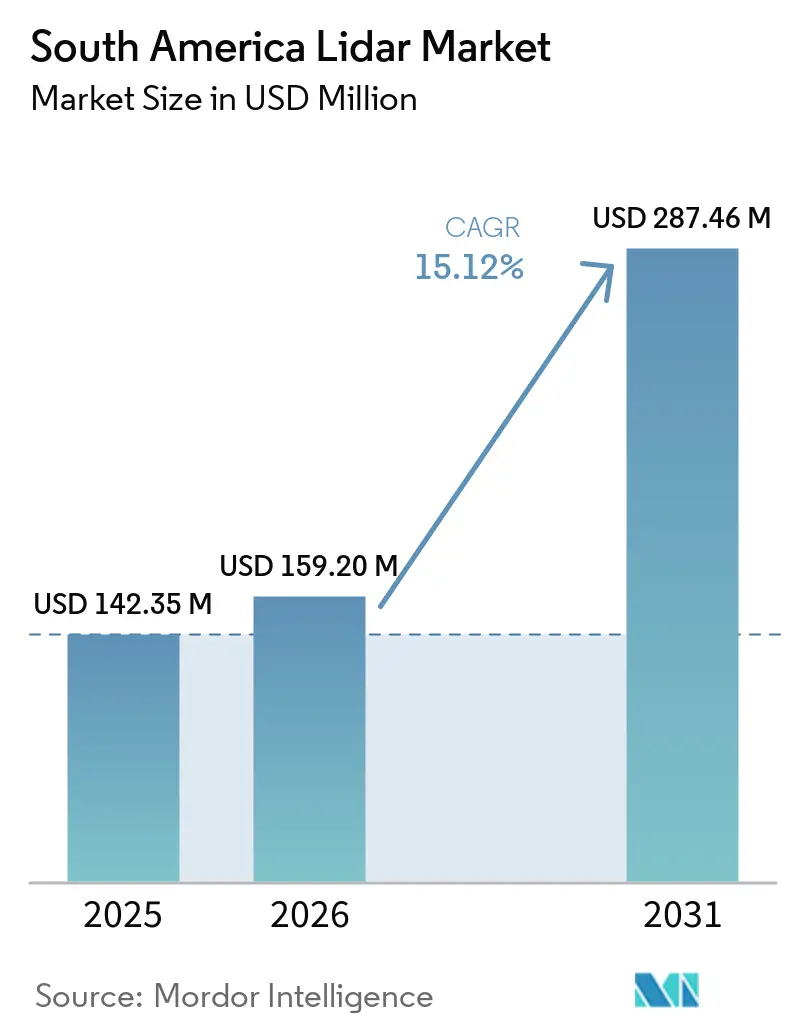
The South America Lidar Market size is expected to increase from USD 142.35 million in 2025 to USD 159.14 million in 2026 and reach USD 321.73 million by 2031, growing at a CAGR of 15.12% over 2026-2031.
Drone surveying, mining operations, environmental mapping, and infrastructure inspection support demand. Difficult terrain and dense forest cover increase the value of detailed geospatial data across multiple project types. Brazil remains the primary source of regional demand, driven by large-scale mining, forest monitoring, energy asset management, and public-sector programs. Digital twin requirements also increase the relevance of point-cloud data for long-term asset management. High import costs and a limited local pool of processing specialists continue to favor service contracts over direct hardware ownership.
Key Report Takeaways
- By product type, aerial LiDAR held 34.00% of the South America LiDAR market share in 2025, while bathymetric LiDAR is projected to expand at an 18.50% CAGR through 2031.
- By component, laser scanners held 40.00% of 2025 revenue, while IMUs are projected to expand at a 16.20% CAGR through 2031.
- By technology, mechanical LiDAR held 50.00% of 2025 revenue, while FMCW LiDAR is projected to expand at a 28.50% CAGR through 2031.
- By range, medium-range systems held 40.00% of 2025 revenue, while long-range systems are projected to expand at a 16.20% CAGR through 2031.
- By installation, airborne systems held 34.00% of 2025 revenue, while UAV-mounted systems are projected to expand at a 22.50% CAGR through 2031.
- By application, mining and exploration held 32.00% of 2025 revenue, while environment and conservation is projected to expand at a 19.20% CAGR through 2031.
- By geography, Brazil held 58.00% of 2025 regional revenue, while the Rest of South America is projected to expand at a 16.50% CAGR through 2031.
Note: Market size and forecast figures in this report are generated using Mordor Intelligence’s proprietary estimation framework, updated with the latest available data and insights as of January 2026.
Market Trends and Insights
Drivers Impact Analysis of South America Lidar Market*
| Driver | (~) % Impact on CAGR Forecast | Geographic Relevance | Impact Timeline |
|---|---|---|---|
| Expansion of UAV and Drone-Based Surveying | +3.2% | South America core, Brazil, Chile, Argentina, and Peru | Short term (≤ 2 years) |
| Mining and Forestry Demand for High-Precision Terrain Data | +2.8% | Brazil, Chile, Argentina, and Peru | Medium term (2-4 years) |
| Infrastructure Digitization and Digital-Twin Deployment | +2.1% | Brazil, with spillover to Argentina and Chile | Medium term (2-4 years) |
| Government-Led Environmental and Disaster-Monitoring Programs | +1.6% | Brazil and Rest of South America | Medium term (2-4 years) |
| Amazon Carbon Accounting and Biodiversity Monitoring Requirements | +1.1% | Brazil's Amazon basin and Rest of South America | Long term (≥ 4 years) |
| Concession-Based Asset Inspection and LiDAR Data-as-a-Service Models | +0.8% | Brazil, Chile, and Argentina | Long term (≥ 4 years) |
| Source: Mordor Intelligence | |||
Expansion of UAV and Drone-Based Surveying
Lightweight LiDAR payloads deployed on longer-endurance drones reduce survey costs per hectare and improve access to remote sites. At a copper-gold mine in Goiás, Brazil, a DJI Matrice 400 equipped with a Zenmuse L3 LiDAR system achieved 3 cm accuracy. The project reduced execution time by 50% compared with ground-based GNSS RTK methods and proceeded without disrupting active mining operations. A 184 km railway mapping project across four Brazilian states demonstrated that aerial LiDAR can support corridor surveys in areas that are difficult to access from the ground[1]. Faster mobilization enables regional operators to compete for smaller assignments that were previously more challenging to serve.
Mining and Forestry Demand for High-Precision Terrain Data
Mining, forestry, and related compliance activities generate recurring demand in the South American LiDAR market. These activities require terrain data for safety assessments, volume measurements, and environmental documentation. In 2025[2]. Chile is expected to adopt mobile LiDAR scanning for 3D monitoring of mine deposits and tailings. Dense canopy cover reduces the effectiveness of conventional photogrammetry across many mining and forestry sites. LiDAR can identify terrain features beneath vegetation, enabling more comprehensive site assessments. Consequently, procurement is tied to compliance schedules and commodity investment cycles.
Infrastructure Digitization and Digital-Twin Deployment
Infrastructure operators increasingly require detailed spatial records throughout an asset's operational life. Survey-grade LiDAR provides point-cloud data that supports digital representations of physical assets. In Brazil, a pipeline project used drones and LiDAR to establish a geospatial baseline for construction activities. This approach helped reduce construction timelines and received recognition at InovaInfra 2026. Research in Brazilian transportation engineering also found that point-cloud-based structural models can represent actual geometry more accurately than plan-based models. These developments position LiDAR as more than a one-time project input, enabling its continued use in asset management.
Government-Led Environmental and Disaster-Monitoring Programs
Public monitoring programs generate sustained demand for LiDAR services. Deforestation enforcement, climate commitments, and disaster planning require reliable terrain and vegetation data. Brazil's partnership among PNUD, MMA, and INPE committed USD 3.4 million to PRODES monitoring across the Caatinga, Pantanal, Mata Atlântica, and Pampa biomes from 2026 to 2028. Under the FLORESTA+ AMAZÔNIA PROJECT, the program requires LiDAR-validated forest reference levels for Brazil's REDD+ submission. Climate finance programs can also fund survey activities that domestic budgets may not fully support. These initiatives enable local geospatial firms to develop expertise that can subsequently support commercial projects.
Restraints Impact Analysis of South America Lidar Market*
| Restraint | (~) % Impact on CAGR Forecast | Geographic Relevance | Impact Timeline |
|---|---|---|---|
| High Acquisition and Post-Processing Costs | -2.0% | Global, most acute in Rest of South America | Short term (≤ 2 years) |
| Import Dependence, Duties, and Currency Volatility | -1.5% | Brazil, Argentina, and Chile | Medium term (2-4 years) |
| Cost-Sensitive Automotive Demand and Limited ADAS Penetration | -0.8% | Brazil | Long term (≥ 4 years) |
| Shortage of Local LiDAR Processing and Calibration Expertise | -0.5% | Rest of South America, Argentina, and Chile | Medium term (2-4 years) |
| Source: Mordor Intelligence | |||
High Acquisition and Post-Processing Costs
Survey-grade aerial systems integrate laser scanners, GNSS, IMUs, and processing software. Imported units typically cost between USD 100,000 and USD 300,000[3]. Many regional service firms and public agencies cannot easily finance such significant equipment investments. Processing also requires licensed software, trained personnel, and rigorous quality-control procedures. Dense canopy further increases the complexity of classification and terrain-model generation. Although data-as-a-service contracts reduce upfront equipment costs, they may concentrate capacity among a limited number of operators.
Import Dependence, Duties, and Currency Volatility
South American LiDAR buyers rely heavily on equipment supplied from Europe, the United States, and China. Import duties, taxes, licensing requirements, and currency fluctuations increase the final cost of this equipment. Brazil imposes several levies on imported optical instruments, including import duty, IPI, ICMS, and PIS/COFINS. In Argentina, foreign exchange controls and import licensing requirements extend procurement lead times. Chile’s lower standard tariff on optical instruments provides local operators with a relative hardware cost advantage. Larger concessionaires can absorb these costs within project budgets, while smaller firms must compete through local service capabilities and skilled operators.
*Our forecasts treat driver/restraint impacts as directional, not additive. The impact forecasts reflect baseline growth, mix effects, and variable interactions.
South America Lidar Market Segment Analysis
By Product Type:
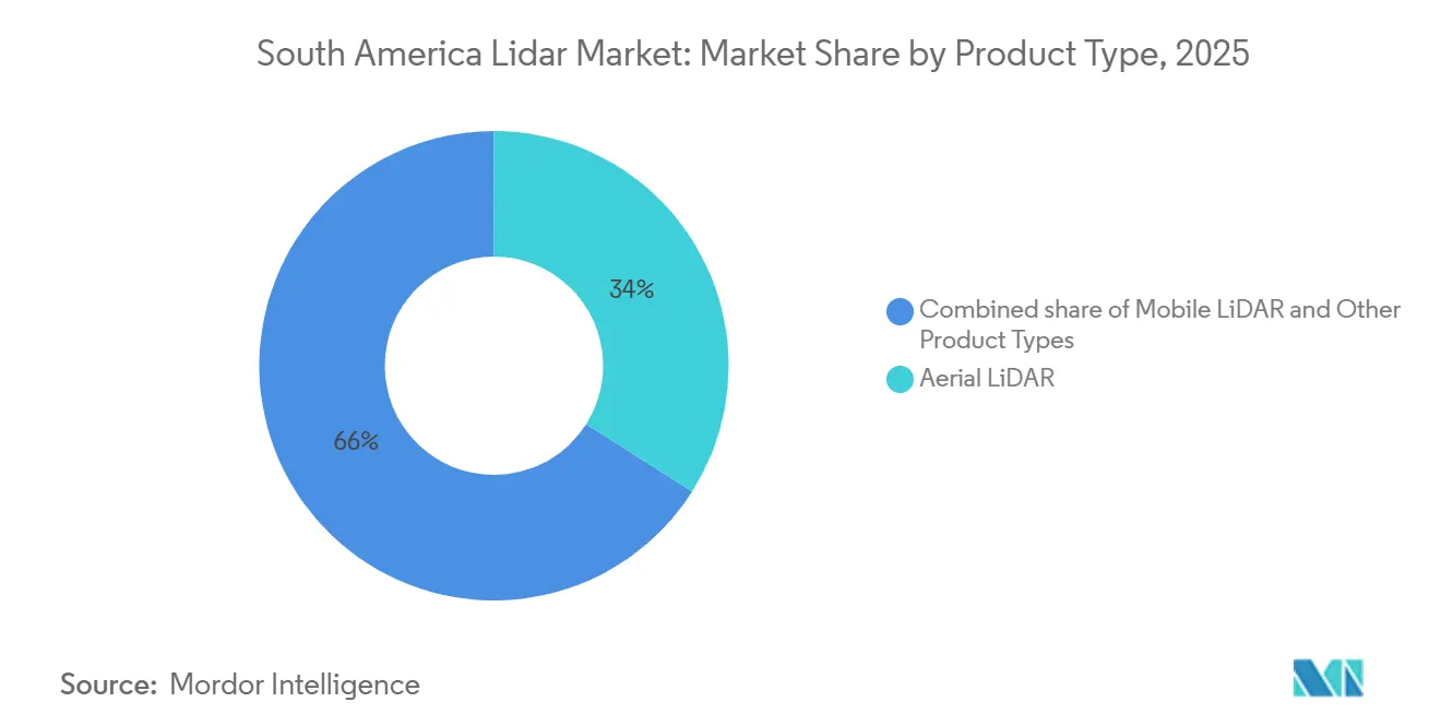
Aerial Platforms Lead Revenue While Bathymetric Work ExpandsAerial LiDAR is projected to account for 34.00% of revenue in 2025, maintaining its leading position in the South America LiDAR market. Airborne acquisition is well suited for large-scale surveys across tropical canopies and Andean terrain, providing broad coverage in areas where road access and ground surveying are challenging. In April 2026, Hexagon R-evolution is scheduled to conduct a rehabilitation mission at Vale's Águas Claras mine. The project will map more than 20 square kilometers at a density exceeding 40 points per square meter, using Leica Geosystems' hybrid airborne system to support mining asset management. Ground-based, mobile, and terrestrial static systems serve confined industrial facilities, urban areas, and underground mines. Their fixed scan geometry supports detailed structural documentation.
Bathymetric LiDAR is projected to grow at a CAGR of 18.50% through 2031, the fastest rate among product types in the South America LiDAR market. Offshore and nearshore survey requirements support this growth segment. Brazil's Atlantic coast is expected to be the primary near-term source of offshore energy activity. In April 2026, Fugro is expected to receive a Petrobras contract for geotechnical investigations for Brazil's 18 MW Rio de Janeiro offshore wind pilot project. The project is expected to become the first South American offshore wind development to enter formal environmental licensing with the Brazilian Institute of Environment and Renewable Natural Resources (IBAMA). Survey work is scheduled to take place from April through the third quarter of 2026. This contract demonstrates how coastal development can generate recurring demand for bathymetric and nearshore data.

By Component:
Laser Scanners Lead Revenue While IMUs Gain ImportanceLaser scanners are projected to account for 40.00% of component revenue in 2025, representing the largest share of the South America LiDAR market by component. The emitter-detector assembly often represents the highest-value subsystem in a LiDAR configuration and determines key performance metrics, including point density, range, and accuracy. Leica Geosystems is expected to launch the RTC300, RTC500, and RTC700 terrestrial scanners in June 2026. The series will include Livelink streaming to Hexagon GeoCloud, reflecting continued investment in terrestrial scanning for infrastructure and digital twin workflows. GNSS and cameras will remain important supporting components in integrated systems.
IMUs are projected to grow at a CAGR of 16.20% through 2031, making them the fastest-growing component group. Drone platforms require precise roll, pitch, and yaw compensation during flight, while accurate trajectory data is essential to maintain centimeter-level point-cloud quality. This requirement becomes increasingly important in canopy-penetration and corridor-mapping missions. YellowScan is expected to introduce the Venturer in February 2026, featuring a Trimble Applanix APX-RTX IMU. The system positions orientation quality as a key consideration in UAV LiDAR selection. Enhanced motion compensation helps operators maintain consistent data quality across changing flight conditions.
By Technology:
Mechanical Systems Hold Share While FMCW Gains GroundMechanical LiDAR is expected to account for 50.00% of revenue in 2025, leading the South America LiDAR market by technology. Its installed base is well established across mining, forestry, and infrastructure survey applications. Rotating designs remain a familiar price-performance option for these use cases. Solid-state and hybrid systems are gaining acceptance in fixed installations and autonomous equipment, as they reduce mechanical complexity in harsh open-pit conditions and support sensor-fusion configurations on autonomous machinery. However, the transition remains gradual because existing mechanical systems are functional and widely understood. Technology selection continues to depend on operating conditions and required data quality.
FMCW LiDAR is projected to expand at a CAGR of 28.50% through 2031, the highest growth rate among technology types. It measures Doppler velocity and range within a single laser sweep, supporting autonomous equipment operating in open-pit mines. A study identified chirp linearity as a key factor affecting FMCW range resolution and described a pathway for terrestrial automation at distances of up to 300 meters. Caterpillar and MicroVision will enter into a development agreement in June 2026 for LiDAR and perception systems for autonomous mining haul trucks. The initial configuration will use two MicroVision Iris sensors on each off-highway truck.
By Range:
Medium-Range Systems Lead While Long-Range Demand RisesMedium-range LiDAR systems with coverage ranges of 200-500 meters are expected to account for 40.00% of revenue in 2025. This range aligns with the 150-400-meter altitudes typically used for standard airborne surveys, supporting the region's largest deployment category. RIEGL, Leica Geosystems, and Teledyne Technologies design survey-grade scanners for these operating conditions. Their systems balance point density and swath width for broad-area applications. Medium-range equipment is widely used for mapping, forestry, and infrastructure inspection. The segment remains important because it integrates with standard aerial survey workflows and meets the practical requirements of large land-area campaigns.
Long-range systems with coverage exceeding 500 meters are projected to expand at a CAGR of 16.20% through 2031. Demand for transmission-line inspections and large-scale topographic surveys supports this growth. Chile's Atacama Desert and Argentina's Patagonia require high-altitude data collection across challenging terrain. Long-range systems can cover these areas while maintaining effective data capture. Adoption also depends on the maturity of national drone regulations. Brazil's certification of XMobots' Nauru 500C for beyond visual line of sight (BVLOS) operations indicates a more supportive regulatory environment for long-range drone missions. Neighboring countries with less developed regulatory frameworks may adopt these systems more slowly.
By Installation:
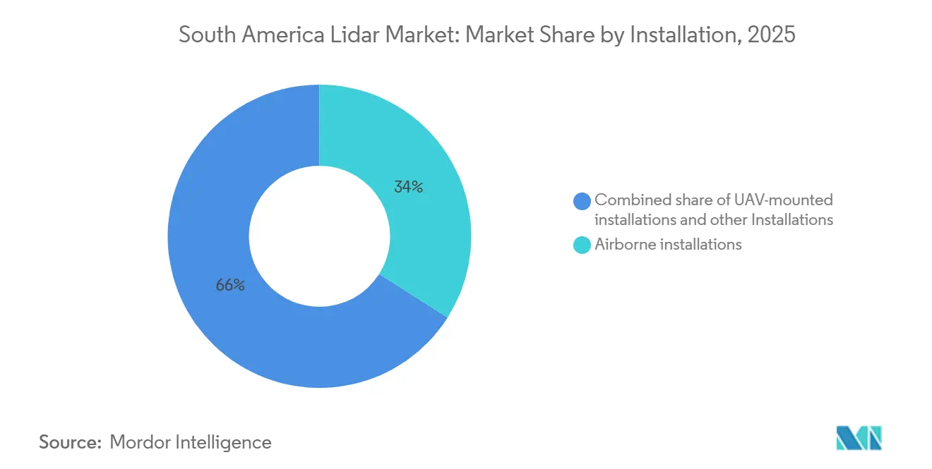
Airborne Systems Remain Important While UAVs Change DeliveryAirborne installations accounted for 34.00% of revenue in 2025, making them the leading installation category. Crewed fixed-wing missions remain valuable for national mapping, forest-concession monitoring, and hydrological surveys across South America’s vast geographic area. These platforms provide extensive coverage in a single campaign. In 2025, Topocart mapped the Tucuruí reservoir for AXIA Energia using airborne LiDAR. The project covered a reservoir with an 8,370 MW capacity at a density of 4 points per square meter and supported reservoir volumetric intelligence. Fixed-wing platforms remain relevant where coverage scale and data density outweigh higher mobilization requirements.
UAV-mounted installations are projected to grow at a CAGR of 22.50% through 2031, representing the fastest growth rate among installation categories. They do not require airfield infrastructure, making them suitable for remote extraction sites and dispersed mining, forestry, and corridor applications. Lower operating costs also enable more frequent surveys. In May 2025, Komatsu adopted Ouster’s Rev8 digital LiDAR sensor for its autonomous mining equipment suite. The sensor supports machine perception in mixed-fleet operations. UAV-compatible sensors can also support autonomous systems at mine sites, reinforcing the connection between drone deployment and automation requirements.
By Application:
Mining Leads Spending While Environmental Work AcceleratesMining and exploration is expected to account for 32.00% of application revenue in 2025, representing the largest share of the South America LiDAR market by application. Recurring surveys support safety management, volumetric reconciliation, and environmental compliance. Chile's Atacama region, Brazil's Carajás complex, and Argentina's Andean provinces drive this demand. LiDAR's canopy penetration capability differentiates it from photogrammetry in tropical and subtropical mining locations. In 2025, AngloGold Ashanti is expected to deploy dynamic underground LiDAR monitoring at its Cuiabá and Serra Grande mines in Brazil. The company will use RoverMap scanning and VoidMapper software to detect rock mass deformation. This deployment demonstrates the use of LiDAR beyond surface surveying.
The environment and conservation application segment is projected to expand at a CAGR of 19.20% through 2031, representing the fastest growth rate among applications. Brazil's Amazonia 3D initiative is expected to begin a LiDAR mapping pilot across 6.4 million hectares in Amazonas state in March 2026. The program will provide open access digital terrain and elevation models, supporting carbon stock estimation and ecosystem classification. Voluntary carbon programs increasingly require LiDAR-validated biomass estimates for credit issuance. These requirements will add private sector demand to public agency procurement and strengthen the capabilities of service providers undertaking conservation assignments.
Geography Analysis
Brazil Lidar Market
Brazil is projected to account for 58.00% of regional revenue in 2025 and hold the leading share of the South American LiDAR market. Its demand base includes mining, forest monitoring, hydroelectric assets, offshore energy, and defense-related applications. Federal deforestation commitments and digital twin requirements further support demand. In April 2026, Hexagon R-evolution is scheduled to launch aerial LiDAR missions for Vale's Águas Claras rehabilitation project. The project will cover more than 20 square kilometers at a density of over 40 points per square meter. Brazil's PNUD-supported biome monitoring program is also expected to provide a public procurement base during 2026–2028.
Chile and Argentina Lidar Market
Chile and Argentina represent significant demand centers for mining and exploration applications. Chile uses periodic 3D geotechnical scanning for mine deposits and tailings management. This practice links procurement to compliance schedules rather than discretionary spending. Chile's lower standard tariff on optical instruments improves the economics of hardware ownership. In Argentina, mining provinces use LiDAR for environmental reporting and licensing workflows. However, foreign-exchange controls and import licensing requirements slow procurement processes. These conditions favor data-as-a-service models for some Argentine operators[4].
Andean South America Lidar Market
The Rest of South America market is projected to grow at a CAGR of 16.50% through 2031, the fastest rate among the region's geographic segments. Peru's Andean copper and gold activities support demand for exploration surveys and tailings management. Colombia's infrastructure rehabilitation programs generate additional demand for asset inspection, while Ecuador's oil and gas assets require inspection services. Operators mobilized from Brazil and Chile often serve these projects. Consequently, the region offers incremental volume opportunities for service providers with flexible deployment models.
Competitive Landscape
The South American LiDAR market is moderately fragmented, with global OEMs, drone specialists, and regional service providers competing across distinct segments. Leica Geosystems, Trimble, RIEGL, FARO Technologies, and Teledyne Technologies maintain premium positions through integrated hardware and software offerings. YellowScan and Ouster compete through drone-ready systems and sensor performance, while regional integrators differentiate themselves through responsiveness and service-based pricing. Hexagon used Leica Geosystems’ hybrid airborne LiDAR technology in its Green Cubes environmental intelligence work for Vale in April 2026. This approach integrates data collection with cloud analytics and sustainability reporting, making the provider’s workflow more central to the customer’s rehabilitation program.
YellowScan introduced the Venturer in February 2026 for government and security-focused missions. The system uses a local processing architecture and an APX-RTX IMU. During 2026, the company also introduced the Mapper Ultra, featuring 500,000 pulses per second, seven returns, a 640-meter range, and a weight of 1.94 kg. These product launches emphasize compliance, payload efficiency, and survey performance rather than price-based competition. In January 2026, XMobots secured a BRL 40 million agreement to adapt Nauru drones for naval and offshore applications. The agreement supports the deployment of Brazilian-made, sensor-equipped platforms in energy and defense applications.
Fugro maintains a presence in floating and nearshore LiDAR through Petrobras-related offshore projects. In 2025, the company received four multiyear contracts from Petrobras for subsea infrastructure inspection and monitoring. Data-as-a-service platforms represent an opportunity as operators increasingly combine point-cloud acquisition with analytical capabilities. These platforms can deliver mine-volume estimates, deforestation alerts, and structural-condition assessments rather than raw data files. PointCloud launched an on-demand acquisition platform in Brazil during 2026. However, this model remains at an early stage and has not yet scaled across the region. The South American LiDAR industry continues to favor companies that combine reliable field deployment with value-added processing and reporting capabilities.
South America Lidar Industry Leaders
-
Leica Geosystems AG
-
Trimble Inc.
-
Teledyne Technologies Incorporated
-
FARO Technologies, Inc.
-
RIEGL Laser Measurement Systems GmbH
- *Disclaimer: Major Players sorted in no particular order

South America Lidar Market Companies Covered in this Report
- Leica Geosystems AG
- Trimble Inc.
- Teledyne Technologies Incorporated
- FARO Technologies, Inc.
- RIEGL Laser Measurement Systems GmbH
- SICK AG
- Hexagon AB
- YellowScan
- Topcon Corporation
- TerraSolid Ltd.
- Ouster, Inc.
- Innoviz Technologies Ltd.
- Hesai Group
- RoboSense Technology Co., Ltd.
- LeddarTech Inc.
- DENSO Corporation
- XMobots Aeroespacial e Sistemas S.A.
- Santos Lab Comércio e Indústria Aeroespacial Ltda.
- Quantum Spatial, Inc.
- Fugro N.V.
Recent Industry Developments in South America Lidar Market
- August 2026: Trimble will expand its RTX Fast high-precision GNSS correction service to Brazil, Paraguay, and Uruguay. The service will deliver horizontal and vertical RMS positioning accuracy of 2 cm and 3 cm, respectively, without requiring physical base stations. It will support higher-precision drone LiDAR georeferencing in areas with sparse CORS coverage.
- June 2026: Caterpillar and MicroVision will sign a Master Development Agreement to develop and commercialize LiDAR and perception technologies for autonomous mining haul trucks. The initial configuration will deploy two MicroVision Iris LiDAR sensors on each Caterpillar off-highway truck. The agreement will follow MicroVision’s planned January 2026 acquisition of Luminar’s LiDAR patent portfolio and inventory for USD 33 million.
- June 2026: Leica Geosystems will launch the RTC300, RTC500, and RTC700 terrestrial laser scanners. The series will include Livelink, which enables real-time streaming to Hexagon GeoCloud for infrastructure and industrial digital twin workflows.
- April 2026: Fugro will receive a Petrobras contract to conduct a geotechnical investigation for Brazil’s 18 MW Rio de Janeiro offshore wind pilot project. Survey operations will run from April through the third quarter of 2026.
- February 2026: YellowScan will unveil the Venturer at GeoWeek 2026. The system will offer NDAA-compliant local data processing, a Trimble Applanix APX-RTX IMU, and 360° adaptive scanning capabilities for government and high-security missions.
South America Lidar Market Report Scope
The South America LiDAR Market is Segmented by Product Type (Aerial, Ground-Based, Mobile, Bathymetric, Terrestrial Static), Component (Laser Scanners, GNSS, IMUs, Cameras), Technology (Mechanical, Solid-State, Hybrid, ToF, FMCW), Range, Installation, and Application (Mining, Infrastructure, Agriculture, Environment, and Others), and Geography (Brazil, Argentina, Chile, Rest of South America). Forecasts in Value (USD).
Segmentation Overview
By Product Type
| Aerial LiDAR |
| Ground-Based LiDAR |
| Mobile LiDAR |
| Bathymetric LiDAR |
| Terrestrial Static LiDAR |
By Component
| Laser Scanners |
| GPS and GNSS Receivers |
| Inertial Measurement Units |
| Cameras and Imaging Modules |
| Computing and Timing Electronics |
| Other Components |
By Technology
| Mechanical LiDAR |
| Solid-State LiDAR |
| Hybrid LiDAR |
| Time-of-Flight LiDAR |
| Frequency-Modulated Continuous-Wave LiDAR |
By Range
| Short Range, Less Than 200 Meters |
| Medium Range, 200-500 Meters |
| Long Range, More Than 500 Meters |
By Installation
| Airborne |
| Ground-Based Static |
| Ground-Based Mobile |
| UAV-Mounted |
By Application
| Mining & Exploration |
| Infrastructure & Urban Planning |
| Agriculture & Forestry |
| Government & Public Agencies |
| Environment & Conservation |
| Power Transmission-Line Inspection |
| Oil & Gas Asset Inspection |
| Other Applications |
by Geography
| Brazil |
| Argentina |
| Chile |
| Rest of South America |
| By Product Type | Aerial LiDAR |
| Ground-Based LiDAR | |
| Mobile LiDAR | |
| Bathymetric LiDAR | |
| Terrestrial Static LiDAR | |
| By Component | Laser Scanners |
| GPS and GNSS Receivers | |
| Inertial Measurement Units | |
| Cameras and Imaging Modules | |
| Computing and Timing Electronics | |
| Other Components | |
| By Technology | Mechanical LiDAR |
| Solid-State LiDAR | |
| Hybrid LiDAR | |
| Time-of-Flight LiDAR | |
| Frequency-Modulated Continuous-Wave LiDAR | |
| By Range | Short Range, Less Than 200 Meters |
| Medium Range, 200-500 Meters | |
| Long Range, More Than 500 Meters | |
| By Installation | Airborne |
| Ground-Based Static | |
| Ground-Based Mobile | |
| UAV-Mounted | |
| By Application | Mining & Exploration |
| Infrastructure & Urban Planning | |
| Agriculture & Forestry | |
| Government & Public Agencies | |
| Environment & Conservation | |
| Power Transmission-Line Inspection | |
| Oil & Gas Asset Inspection | |
| Other Applications | |
| by Geography | Brazil |
| Argentina | |
| Chile | |
| Rest of South America |
Key Questions Answered in the Report
What is the South America LiDAR market size?
The South America LiDAR market size is estimated at USD 159.14 million in 2026 and is forecast to reach USD 321.73 million by 2031.
What is driving LiDAR adoption in South America?
Drone surveying, mining compliance, environmental monitoring, and infrastructure asset management support adoption.
Which product type leads regional LiDAR revenue?
Aerial LiDAR led product revenue with a 34.00% share in 2025 because it supports wide-area mapping over difficult terrain.
Which application is expanding fastest?
Environment and conservation is projected to expand at a 19.20% CAGR through 2031, supported by carbon and biodiversity mapping needs.
Why is Brazil important for LiDAR providers?
Brazil accounted for 58.00% of regional revenue in 2025 and combines mining, forest monitoring, energy, and infrastructure demand.
What limits adoption by smaller LiDAR service firms?
Imported equipment costs, duties, currency exposure, and the shortage of processing specialists limit direct hardware ownership.