
Geophysical Service Market Size and Share
Market Overview
| Study Period | 2022 - 2032 |
|---|---|
| Market Size (2027) | USD 17.31 Billion |
| Market Size (2032) | USD 20.91 Billion |
| Growth Rate (2027 - 2032) | 3.86 % |
| Fastest Growing Market | Asia-Pacific |
| Largest Market | North America |
| Market Concentration | Medium |
Major Players *Disclaimer: Major Players sorted in no particular order Image © Mordor Intelligence. Reuse requires attribution under CC BY 4.0. | |
Geophysical Service Market Analysis by Mordor Intelligence
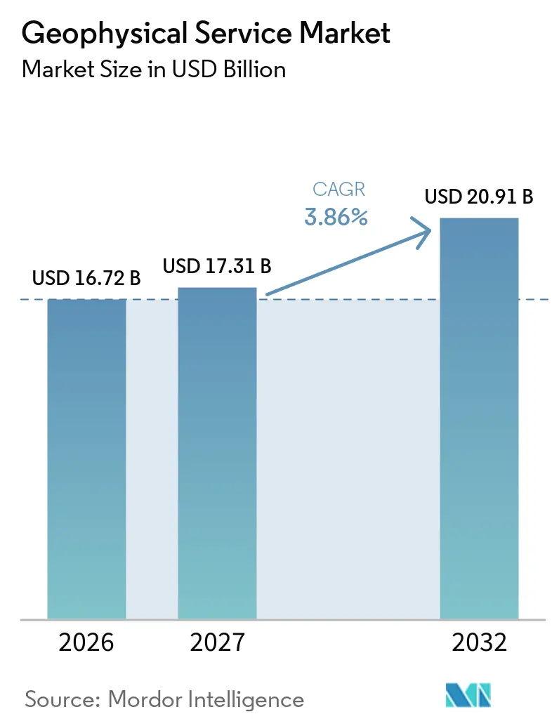
The Geophysical Service Market size is projected to expand from USD 16.72 billion in 2026 and USD 17.31 billion in 2027 to USD 20.91 billion by 2032, registering a CAGR of 3.86% between 2027 and 2032. The geophysical service market is supported by offshore exploration, critical-mineral programs, offshore wind development, and the monitoring needs of carbon storage projects. Demand is moving toward deeper and more complex settings, where better subsurface imaging can reduce uncertainty before drilling, construction, or storage operations begin. Providers are also combining acquisition, processing, imaging, and data licensing in one offering, which can reduce handoffs for clients and improve the usefulness of survey data. Cloud processing is becoming important because it supports large data volumes while helping providers address national rules on data storage and processing. Commodity-price uncertainty, tighter marine permitting, and changes in multi-client funding continue to limit the pace of the geophysical service market.
Key Report Takeaways
- By service type, Seismic Survey Services held 52.3% of the geophysical service market share in 2026, while Ground-Penetrating Radar Services are forecast to grow at a 4.5% CAGR through 2032.
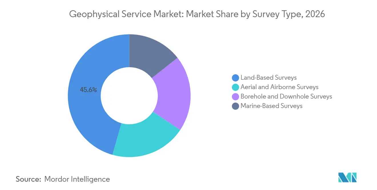
- By survey type, Land-Based Surveys accounted for 45.6% of revenue in 2026, while Aerial and Airborne Surveys are forecast to grow at a 4.1% CAGR through 2032.
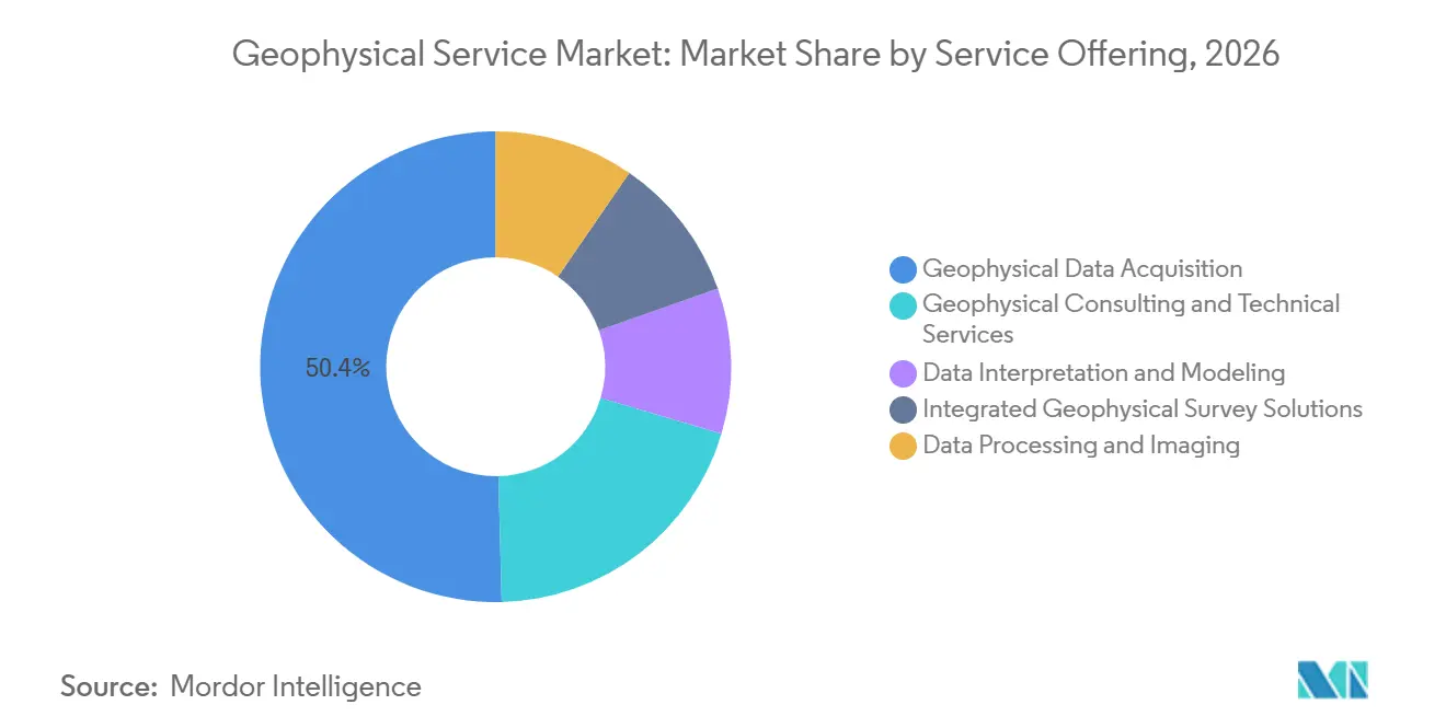
- By service offering, Geophysical Data Acquisition held 50.4% of revenue in 2026, while Integrated Geophysical Survey Solutions is expected to expand at a 4.8% CAGR through 2032.
- By application, Oil and Gas Exploration and Production accounted for 57.3% of revenue in 2026, while Carbon Capture, Utilization, and Storage (CCUS) is projected to grow at a 4.8% CAGR through 2032.
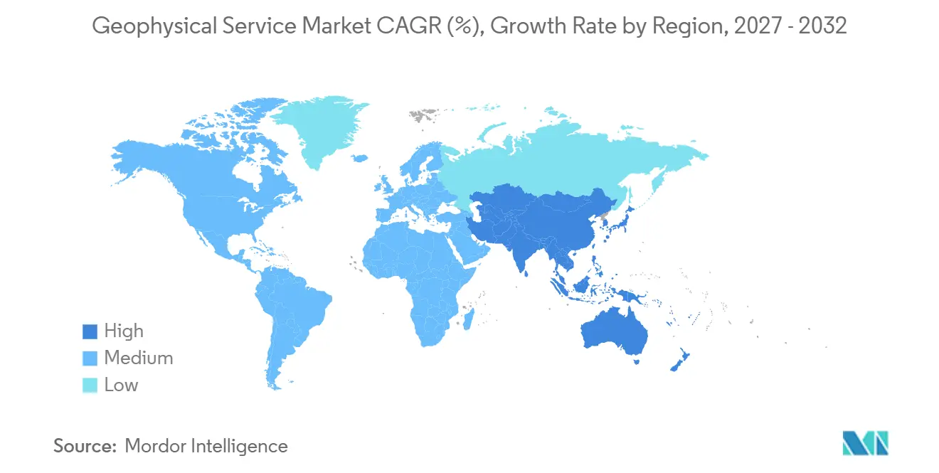
- By geography, North America held 62.3% of revenue in 2026, while Asia-Pacific is forecast to advance at a 4.2% CAGR through 2032.
Note: Market numbers in this report are based on Mordor Intelligence's proprietary estimation framework, which combines nine months of actuals with Q4 projections for base year 2026.
Market Trends and Insights
Drivers Impact Analysis of Geophysical Service Market*
| Driver | (~) % Impact on CAGR Forecast | Geographic Relevance | Impact Timeline |
|---|---|---|---|
| Offshore Exploration And Deepwater Development | +1.1% | Global, led by Gulf of America, West Africa, Asia-Pacific | Short term (≤ 2 years) |
| Critical-Mineral And Energy-Transition Exploration | +0.7% | APAC, Australia, South America, Canada, Sub-Saharan Africa | Medium term (2-4 years) |
| Offshore-Wind Site Characterization And Seabed Risk Reduction | +0.5% | Europe, APAC, U.S. East Coast | Medium term (2-4 years) |
| CCUS, Geothermal, And Subsurface Energy Monitoring | +0.3% | Europe, North America, APAC | Long term (≥ 4 years) |
| AI-Enabled Interpretation And Cloud Processing | +0.4% | Global | Medium term (2-4 years) |
| Reusable Multi-Client Data Libraries And Data Licensing | +0.2% | North America, South America, Europe | Medium term (2-4 years) |
| Source: Mordor Intelligence | |||
Offshore Exploration and Deepwater Development
Reserve replacement needs are bringing more work into deepwater areas, where complex geology often requires detailed marine seismic acquisition. In August 2026, Shearwater received 2 awards from ONGC for offshore 3D seismic surveys on India’s west and east coasts, with work periods of 9 months and 6 months, respectively.[1] The awards add 15 vessel months of backlog and extend planned fleet activity into 2027. Ocean Bottom Node (OBN) acquisition is gainingg importance where wide-azimuth imaging is needed in complex pre-salt reservoirs. In September 2026, Shearwater announced a 3-year OBN acquisition contract offshore South America, with firm scope in the 1st and 3rd years. These longer commitments give service providers more dependable vessel planning than individual survey campaigns.
Deepwater programs also create follow-on work in borehole logging, processing, imaging, and site characterization. This wider work scope favors companies that can connect acquisition data with interpretation and reservoir decisions. In January 2026, TGS started the APEX 1 OBN multi-client program across 151 Outer Continental Shelf (OCS) blocks in the Gulf of Mexico.[2] The project uses long-offset acquisition to support several geological objectives and retain flexibility for later exploration activity. The geophysical service market therefore benefits when offshore operators commit to longer exploration and production programs. It also becomes more exposed to delays in vessel access, permitting, and capital spending.
Critical-Mineral and Energy-Transition Exploration
Critical-mineral exploration is increasing the need for surveys that identify deep deposits before drilling begins. The International Energy Agency reported in 2025 that copper demand is set to double by 2050, while existing mines are aging and new discoveries remain difficult.[3] These conditions increase the value of geophysical methods that screen large areas more quickly than drilling alone. Airborne and drone-based surveys can combine magnetic, electromagnetic, gravity, and other measurements across difficult terrain. The AGEMERA (Accelerating Geophysical Methods for Exploration of Raw materials in Atypical geological settings) project is evaluating ambient-noise seismology, muography, and drone-borne electromagnetic methods for critical raw material exploration across 7 countries.[4] This work shows why multi-method programs are becoming more relevant for deposits with complex structures.
Government-supported mapping programs can provide demand that is less tied to short-term mining budgets. Such programs also create base datasets that may guide later private exploration activity. The geophysical service market can benefit when public agencies seek broad coverage across underexplored regions. Service providers with airborne systems and multi-physics expertise are better placed to compete for this work. Wider deployment of unmanned systems is also reducing the cost of collecting information in remote areas. The resulting workflow can improve early targeting and help explorers narrow the locations that require drilling.
Offshore-Wind Site Characterization and Seabed Risk Reduction
Offshore wind projects require survey work before foundation design and cable installation can move ahead. In June 2025, Fugro received geophysical and geotechnical contracts for the 4-GW Windbostel Ost and Windbostel West projects in the German North Sea. The projects are being developed by a joint venture between RWE and TotalEnergies. They demonstrate that large developments need coordinated geophysical and geotechnical assessment before construction. The work is less dependent on oil prices than conventional exploration activity.
High-resolution seismic methods can identify shallow hazards that affect turbine foundations, export cables, and construction schedules. Integrated site investigation can also help clients avoid delays caused by separate survey programs. Germany’s wind-area characterization program supports a pipeline of publicly directed survey procurement. Fugro completed geophysical work for the 1 GW N-9.5 site in the German North Sea during April and May 2025. Offshore wind gives the geophysical service market a source of demand outside the hydrocarbon cycle. It also increases the importance of shallow-water operations, environmental planning, and seabed engineering knowledge.
AI-Enabled Interpretation and Cloud Processing
Cloud platforms are changing how providers process seismic data and deliver information to clients. In March 2026, TGS selected Amazon Web Services (AWS) as its preferred cloud provider through a multi-year agreement covering petabyte-scale multi-client libraries and scalable processing. The agreement supports Elastic Full Waveform Inversion workloads and in-country Graphics Processing Unit (GPU) processing in Brazil. This is relevant where data-sovereignty rules require processing to occur within a country. It can also lower the need for providers to maintain large dedicated computing systems.
TGS is using the arrangement to develop a Subsurface Foundation Model through Amazon Bedrock. Halliburton also used Amazon Bedrock to develop a natural-language assistant for creating workflows within Seismic Engine. These examples show that automated tools are moving into processing workflow design as well as interpretation. Providers with strong proprietary data and proven processing methods can use them to improve speed and consistency. The geophysical service market may see a wider gap between companies with large data libraries and firms that only supply acquisition capacity. Data interoperability standards may still increase price pressure in standard processing work.
Restraints Impact Analysis of Geophysical Service Market*
| Restraint | (~) % Impact on CAGR Forecast | Geographic Relevance | Impact Timeline |
|---|---|---|---|
| Commodity-Price And Exploration-Capex Volatility | -0.7% | Global, most acute in North America and West Africa | Short term (≤ 2 years) |
| Environmental Permitting And Marine-Noise Constraints | -0.5% | Global, with stronger compliance influence in EU, U.S., UK, Australia | Medium term (2-4 years) |
| Shrinking Multi-Client Pre-Funding And Data-Ownership Risk | -0.3% | North America, Norway, Brazil | Medium term (2-4 years) |
| Vessel, Node, And Specialist-Crew Bottlenecks | -0.2% | Global marine segment | Medium term (2-4 years) |
| Source: Mordor Intelligence | |||
Commodity-Price and Exploration-Capex Volatility
Oil price changes can alter exploration plans before survey work begins. This can reduce the visibility that providers need when making commitments to vessels, nodes, and crews. During weaker price periods, operators can seek smaller scopes or lower day rates rather than canceling every project. This can protect vessel utilization while reducing contract margins. Providers that work across offshore wind, critical minerals, CCUS, and hydrocarbons are less dependent on a single investment cycle. The geophysical service market remains closely linked to upstream capital spending because oil and gas exploration and production remain their largest application.
The risk is most visible for high-cost frontier programs that require several years of spending before drilling can begin. Multi-client surveys face a related issue when prospective buyers delay data purchases or reduce pre-funding commitments. A stronger mix of licensing revenue, contracted acquisition, and processing services can reduce dependence on a single customer decision. Long-duration projects can also give providers more stable scheduling than short survey campaigns. Geographic diversification offers another buffer because commodity cycles and licensing activity do not move at the same pace everywhere. These approaches do not remove the risk, but they can reduce the effect of abrupt changes in exploration budgets.
Environmental Permitting and Marine-Noise Constraints
Marine survey permits are becoming more detailed as regulators assess effects on marine mammals and local ecosystems. The Joint Nature Conservation Committee issued updated guidance for reducing the risk of injury to marine mammals from geophysical surveys in 2025. The guidance addresses measures such as exclusion zones, soft-start procedures, and monitoring during survey operations. In the Gulf of America, the U.S. National Marine Fisheries Service issued authorizations under the Marine Mammal Protection Act for oil and gas-related geophysical surveys in 2025. These requirements can extend planning and increase the amount of site-specific documentation needed before operations start.
The Bureau of Ocean Energy Management stated in 2025 that incorporating acoustic quieting measures early can reduce later costs, although appropriate mitigation differs by ice conditions, bathymetry, and seasonal wildlife presence. This means there is no single permitting approach that providers can use across all marine basins. Smaller firms may find it harder to maintain the technical and regulatory resources needed for several jurisdictions. Larger integrated providers can use established environmental procedures across a broader project base. The restraint may also increase interest in acquisition methods that reduce operational duration or limit noise exposure. Environmental compliance is therefore an operational requirement rather than a separate consideration for the geophysical service market.
*Our forecasts treat driver/restraint impacts as directional, not additive. The impact forecasts reflect baseline growth, mix effects, and variable interactions.
Geophysical Service Market Segment Analysis
By Service Type:
Seismic Remains the Largest Service While GPR ExpandsSeismic Survey Services held 52.3% of the geophysical service market share in 2026, reflecting their use in offshore exploration, reservoir monitoring, offshore wind, CCUS, and geothermal work. Seismic remains central where clients need images of deeper subsurface structures before expensive development decisions. In August 2026, TGS launched Gemini X, which combines its Gemini Enhanced Frequency Source with Apparition simultaneous-source encoding. TGS reported efficiency gains of up to 30% in Gulf of America trials. Magnetic, gravity, electromagnetic, and electrical methods complement seismic work where clients need several measurements to understand difficult mineral targets.
Ground-Penetrating Radar (GPR) Services are forecast to grow at a 4.5% CAGR through 2032 within the geophysical service market. The service is used for utility mapping, civil engineering review, road assessment, archaeological work, and concrete condition checks. Its broad set of uses gives it exposure to infrastructure activity outside energy exploration. Clients often need specialized field collection and interpretation because the usefulness of GPR depends on local ground conditions and project design. This supports outsourced service demand rather than equipment purchases alone.
By Survey Type:
Land-Based Work Leads While Airborne Methods Gain UseLand-Based Surveys accounted for 45.6% of the geophysical service market in 2026, supported by activity in the Permian Basin, Western Canada, and national programs in China and India. Land work remains important for hydrocarbon exploration, mining, groundwater assessment, and public geological mapping. It can be easier to deploy than marine acquisition, although access, landowner approvals, and terrain continue to affect schedules. BGP operates across more than 80 countries and remains active in onshore acquisition in China and international locations. Marine surveys form the second-largest category, with Ocean Bottom Node (OBN) work gaining use in complex reservoir settings.
Aerial and Airborne Surveys are forecast to grow at a 4.1% CAGR through 2032. The segment supports mineral exploration, initial offshore wind reconnaissance, and national mapping programs. Improved drone payloads and navigation can make high-resolution coverage more accessible in remote locations. Airborne methods may reduce early drilling requirements by helping explorers focus field programs on smaller areas. This makes the geophysical service market relevant to mining companies and public agencies with broad survey needs.
By Service Offering:
Data Acquisition Generates Volume While Integrated Solutions Grow FasterGeophysical Data Acquisition held 50.4% of revenue in 2026, giving it the largest share of the geophysical service market size by service offering. Vessel operations, land crews, equipment, and field logistics make acquisition a capital-intensive part of the value chain. Large field contracts can create substantial revenue before processing or interpretation is added. Data processing and imaging provide the next stage of value by turning field measurements into useful subsurface information. TGS’s cloud agreement supports in-country GPU processing for elastic Full Waveform Inversion (eFWI) in Brazil.
Integrated Geophysical Survey Solutions are projected to grow at a 4.8% CAGR through 2032. Clients use integrated services to coordinate acquisition, processing, interpretation, and consulting under one provider. This approach can reduce delays between separate work packages and create clearer responsibility for final delivery. Fugro’s Windbostel work combines geophysical and geotechnical scope within a single project structure. Consulting services can add value in deepwater and pre-salt areas where data is difficult to interpret.
By Application:
Oil And Gas Leads While CCUS Adds Long-Term Monitoring WorkOil and Gas Exploration and Production held 57.3% of the geophysical service market share in 2026. Hydrocarbon projects require data for exploration, appraisal, development, and production monitoring. The mix of spending is shifting toward reservoir monitoring and 4D surveys as operators seek to improve recovery from producing assets. Mineral exploration, groundwater assessment, environmental investigations, civil engineering, and renewable energy applications provide additional demand. These applications can soften the effect of lower oil and gas spending in some locations.
CCUS is forecast to grow at a 4.8% CAGR through 2032, matching the highest growth rate among applications. Storage projects require monitoring, measurement, and verification over long periods, creating a need for repeated subsurface measurements. A 2026 peer-reviewed review discussed the role of multiple monitoring technologies in geological storage. The CO2CRC Otway Project used a February 2025 monitor survey for time-lapse borehole seismic imaging. Fiber-optic and borehole methods can complement repeat surface seismic work. This application can provide recurring geophysical service market work after the initial storage site has been developed.
Geography Analysis
North America and Brazil Geophysical Service Market
North America held 62.3% of the geophysical service market share in 2026. The Gulf of America remains the region’s leading offshore survey area, with OBN acquisition setting a benchmark for subsalt imaging. TGS began the APEX 1 long-offset OBN program across 151 Outer Continental Shelf (OCS) blocks in January 2026. Brazil provides a further source of marine geophysical service market demand through its pre-salt basins and multi-client activity.
EMEA Geophysical Service Market
Europe combines North Sea production monitoring with offshore wind characterization and mineral exploration. Norway and the United Kingdom remain important for offshore reservoir work and OBN activity. Fugro’s 2025 work at Germany’s N-9.5 wind site shows the role of public wind-area characterization in the region. The Middle East and Africa are supported by exploration programs in Saudi Arabia and the United Arab Emirates. Morocco, Egypt, and Sub-Saharan markets attract airborne gravity and magnetic work for hydrocarbon and strategic-mineral prospectivity, supporting the geophysical service market across marine, land, and airborne services.
APAC Geophysical Service Market
Asia-Pacific is forecast to grow at a 4.2% CAGR through 2032. India’s offshore licensing activity is increasing 3D seismic surveys on both coasts, and Shearwater’s Oil and Natural Gas Corporation (ONGC) awards in August 2026 represent 15 vessel months of planned work. China’s deepwater work supports domestic technology and service capacity, while Australia, Indonesia, Malaysia, and Vietnam add demand across hydrocarbons, minerals, and offshore wind. Viridien began imaging its Langkasuka MC3D hybrid survey offshore Malaysia in October 2026, combining streamer and sparse OBN data.
Competitive Landscape
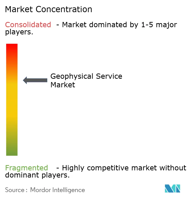
The geophysical service market has moderately concentrated in marine acquisition and multi-client data, where a limited group of integrated providers operate large streamer and OBN fleets. Land and near-surface work is more fragmented because regional specialists compete through access, local operating knowledge, equipment availability, and mobilization speed. Integrated platforms have an advantage when clients want acquisition, imaging, interpretation, and data licensing under one commercial relationship. TGS, Viridien, Fugro, and Shearwater are among the companies making investments that strengthen this position. Technology ownership is becoming more important because it can affect both imaging quality and field efficiency.
TGS acquired Apparition Geoservices in June 2026, gaining exclusive access to simultaneous-source acquisition and separation technology. The company then introduced Gemini X in August 2026, applying that technology to seismic acquisition workflows. TGS also expanded its cloud strategy through the March 2026 agreement with Amazon Web Services (AWS) for multi-client delivery and scalable processing. These moves connect field operations, large data libraries, and advanced processing. Competitors without comparable data assets or access to specialized technology may find it harder to match this combined offering.
Shearwater is strengthening its position through the Oil and Natural Gas Corporation (ONGC) 3D survey awards and the South American OBN contract. Fugro continues to serve offshore wind and infrastructure clients through combined geophysical and geotechnical work. CCUS monitoring and critical-mineral surveys remain areas where providers are building capabilities, without a company identified in the draft as a leader comparable to its hydrocarbon position. Open Subsurface Data Universe standards may make data transfers easier, so geophysical service market providers must compete through differentiated data, specialized imaging, environmental compliance, and complex-project management.
Geophysical Service Industry Leaders
-
BGP Inc.
-
Schlumberger Limited (SLB)
-
Viridien
-
Fugro N.V.
-
TGS ASA
- *Disclaimer: Major Players sorted in no particular order
Geophysical Service Market Companies Covered in this Report
- Abitibi Geophysics
- BGP Inc.
- China Oilfield Services Limited (COSL)
- Dawson Geophysical Company
- DMT GmbH & Co. KG
- Fugro N.V.
- Geophysical Survey Systems, Inc.
- Geospace Technologies Corporation
- Getech Group plc
- Getech Group plc
- Halliburton Company
- INOVA Geophysical
- Phoenix Geophysics Limited
- PXGEO
- SAExploration Holdings, Inc.
- Schlumberger Limited (SLB)
- SeaBird Exploration PLC
- Sercel
- Shearwater GeoServices Holding AS
- STRYDE Ltd.
- TGS ASA
- Viridien
- Xcalibur Multiphysics
Recent Industry Developments in Geophysical Service Market
- September 2026: Shearwater Geoservices was awarded a significant 3-year OBN seismic acquisition contract with a major oil company offshore South America, executed using the SW Tasman vessel and Pearl node technology with firm scopes in Years 1 and 3.
- August 2026: Viridien commenced seismic imaging of the Langkasuka MC3D hybrid survey, the first-ever combined streamer and sparse OBN multi-client 3D dataset in Asia-Pacific, integrating 12,300 sq km of streamer data and 3,300 sq km of OBN data in the Malacca Strait offshore West Peninsular Malaysia.
- August 2026: TGS launched Gemini X, combining the Gemini Enhanced Frequency Source with Apparition simultaneous-source encoding for multi-source seismic acquisition.
- August 2026: Shearwater received 2 LOAs from ONGC for 3D seismic surveys on India’s west coast and east coast, adding 15 vessel months of backlog with both projects commencing in Q4 2026.
Global Geophysical Service Market Report Scope
A geophysical service is a specialized scientific and engineering activity that uses non-invasive physical measurements at the Earth's surface to map and analyze subsurface conditions. Rather than drilling, digging, or tunneling, geophysicists deploy instruments to detect changes in physical fields. The raw data collected is then processed and interpreted to generate maps of underground rock structures, fluids, voids, and mineral deposits.
The global geophysical services market is segmented by service type, survey type, service offering, application, and geography. By service type, the market is segmented into seismic survey services, magnetic survey services, gravity survey services, electromagnetic survey services, electrical resistivity and induced polarization services, borehole geophysical logging services, ground-penetrating radar (GPR) services, and other geophysical services. By survey type, the market is segmented into land-based surveys, marine-based surveys, aerial and airborne surveys, and borehole and downhole surveys. By service offering, the market is segmented into geophysical data acquisition, data processing and imaging, data interpretation and modeling, integrated geophysical survey solutions, and geophysical consulting and technical services. By application, the market is segmented into oil and gas exploration and production, mineral and mining exploration, groundwater and water resource exploration, geothermal energy exploration, environmental site investigation, civil engineering and infrastructure development, carbon capture, utilization and storage (CCUS), renewable energy project site assessment, agriculture and soil mapping, and other applications. The report also covers the market size and forecasts for the global geophysical service market across 26 countries in key regions. For each segment, the market sizing and forecasts have been provided on the basis of value (USD).
Segmentation Overview
| Seismic Survey Services |
| Magnetic Survey Services |
| Gravity Survey Services |
| Electromagnetic Survey Services |
| Electrical Resistivity and Induced Polarization Services |
| Borehole Geophysical Logging Services |
| Ground-Penetrating Radar (GPR) Services |
| Other Geophysical Services |
| Land-Based Surveys |
| Marine-Based Surveys |
| Aerial and Airborne Surveys |
| Borehole and Downhole Surveys |
| Geophysical Data Acquisition |
| Data Processing and Imaging |
| Data Interpretation and Modeling |
| Integrated Geophysical Survey Solutions |
| Geophysical Consulting and Technical Services |
| Oil and Gas Exploration and Production |
| Mineral and Mining Exploration |
| Groundwater and Water Resource Exploration |
| Geothermal Energy Exploration |
| Environmental Site Investigation |
| Civil Engineering and Infrastructure Development |
| Carbon Capture, Utilization and Storage (CCUS) |
| Renewable Energy Project Site Assessment |
| Agriculture and Soil Mapping |
| Other Applications |
| North America | United States |
| Canada | |
| Mexico | |
| Europe | Germany |
| France | |
| Italy | |
| Spain | |
| United Kingdom | |
| Poland | |
| Russia | |
| Rest of Europe | |
| Asia-Pacific | China |
| India | |
| Japan | |
| South Korea | |
| Australia | |
| Indonesia | |
| Vietnam | |
| Thailand | |
| Rest of Asia-Pacific | |
| South America | Brazil |
| Argentina | |
| Chile | |
| Rest of South America | |
| Middle East and Africa | Saudi Arabia |
| United Arab Emirates | |
| Egypt | |
| South Africa | |
| Morocco | |
| Rest of Middle East and Africa |
| By Service Type | Seismic Survey Services | |
| Magnetic Survey Services | ||
| Gravity Survey Services | ||
| Electromagnetic Survey Services | ||
| Electrical Resistivity and Induced Polarization Services | ||
| Borehole Geophysical Logging Services | ||
| Ground-Penetrating Radar (GPR) Services | ||
| Other Geophysical Services | ||
| By Survey Type | Land-Based Surveys | |
| Marine-Based Surveys | ||
| Aerial and Airborne Surveys | ||
| Borehole and Downhole Surveys | ||
| By Service Offering | Geophysical Data Acquisition | |
| Data Processing and Imaging | ||
| Data Interpretation and Modeling | ||
| Integrated Geophysical Survey Solutions | ||
| Geophysical Consulting and Technical Services | ||
| By Application | Oil and Gas Exploration and Production | |
| Mineral and Mining Exploration | ||
| Groundwater and Water Resource Exploration | ||
| Geothermal Energy Exploration | ||
| Environmental Site Investigation | ||
| Civil Engineering and Infrastructure Development | ||
| Carbon Capture, Utilization and Storage (CCUS) | ||
| Renewable Energy Project Site Assessment | ||
| Agriculture and Soil Mapping | ||
| Other Applications | ||
| By Geography | North America | United States |
| Canada | ||
| Mexico | ||
| Europe | Germany | |
| France | ||
| Italy | ||
| Spain | ||
| United Kingdom | ||
| Poland | ||
| Russia | ||
| Rest of Europe | ||
| Asia-Pacific | China | |
| India | ||
| Japan | ||
| South Korea | ||
| Australia | ||
| Indonesia | ||
| Vietnam | ||
| Thailand | ||
| Rest of Asia-Pacific | ||
| South America | Brazil | |
| Argentina | ||
| Chile | ||
| Rest of South America | ||
| Middle East and Africa | Saudi Arabia | |
| United Arab Emirates | ||
| Egypt | ||
| South Africa | ||
| Morocco | ||
| Rest of Middle East and Africa | ||
Key Questions Answered in the Report
What is driving demand for geophysical services?
Offshore exploration, critical-mineral exploration, offshore wind site work, and CCUS monitoring support demand across several uses.
How large is the geophysical service market?
The geophysical service market is projected to increase from USD 17.31 billion in 2027 to USD 20.91 billion by 2032 at a 3.86% CAGR.
Which service has the largest revenue share?
Seismic Survey Services held the largest share at 52.3% in 2026.
Which geophysical service is growing fastest?
Ground-Penetrating Radar Services are forecast to grow at a 4.5% CAGR through 2032.
Which region leads global geophysical services?
North America held 62.3% of revenue in 2026, while Asia-Pacific is forecast to grow fastest at a 4.2% CAGR through 2032.
Why are integrated survey solutions gaining adoption?
They bring acquisition, processing, interpretation, and consulting together, which can reduce handoffs and improve the speed of project delivery.