Market Overview
| Study Period | 2020 - 2031 |
|---|---|
| Forecast Data Period | 2026 - 2031 |
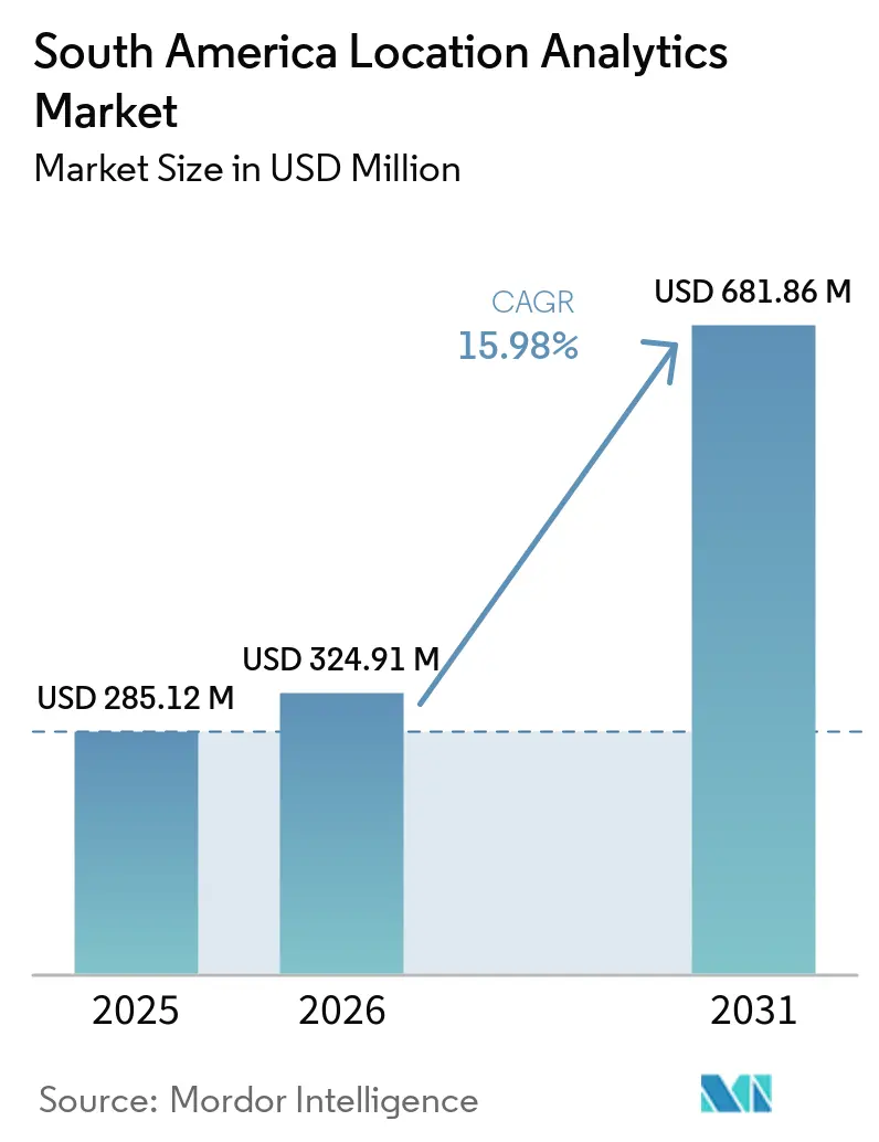
| Base Year Market Size (2025) | USD 285.12 Million |
| Market Size (2026) | USD 324.91 Million |
| Market Size (2031) | USD 681.86 Million |
| Growth Rate (2026 - 2031) | 15.98 % |
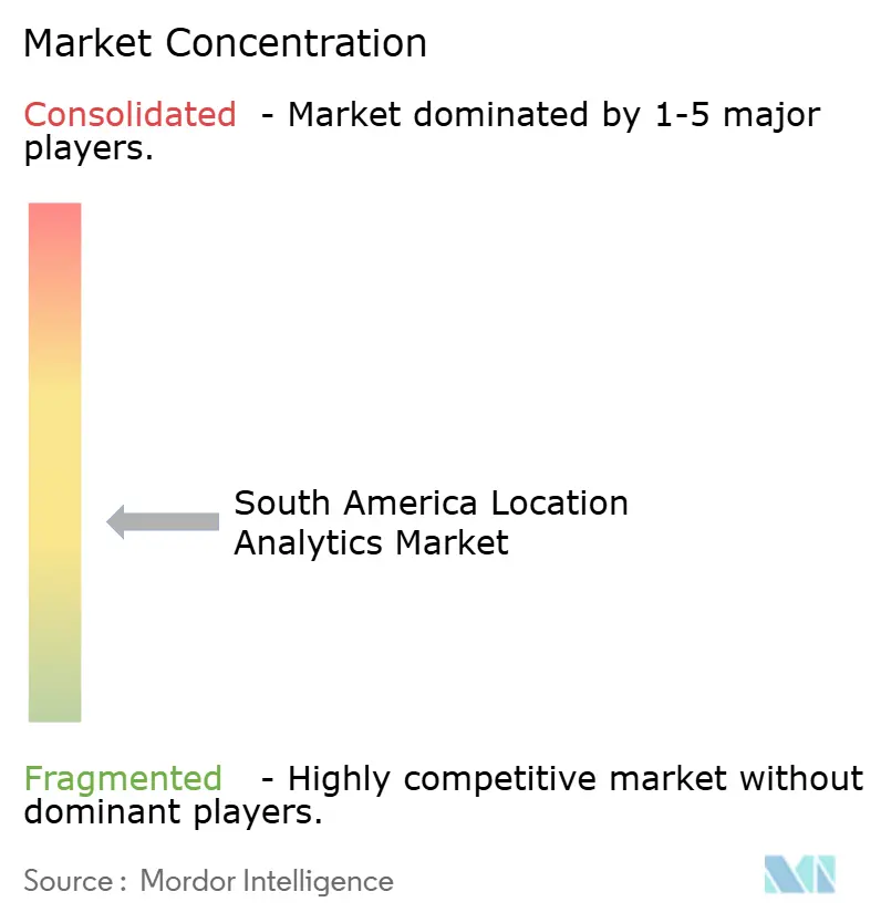
| Market Concentration | Medium |
Major Players *Disclaimer: Major Players sorted in no particular order Image © Mordor Intelligence. Reuse requires attribution under CC BY 4.0. | |
South America Location Analytics Market Analysis by Mordor Intelligence
The South America location analytics market size was USD 285.12 million in 2025 and is estimated to increase from USD 324.91 million in 2026 to USD 681.86 million by 2031, at a CAGR of 15.98% during 2026-2031. The South America location analytics market is shifting from periodic mapping projects to tools that support daily operational decisions. Cloud infrastructure and connected devices are making large location data sets more practical to use across the region. Buyers increasingly need systems that link maps, data pipelines, and operational applications without long implementation cycles. This favors vendors that can combine local data coverage with simpler cloud delivery. The South America location analytics market also has room for specialized providers because address quality, connectivity, and privacy requirements differ sharply across countries.
Key Report Takeaways
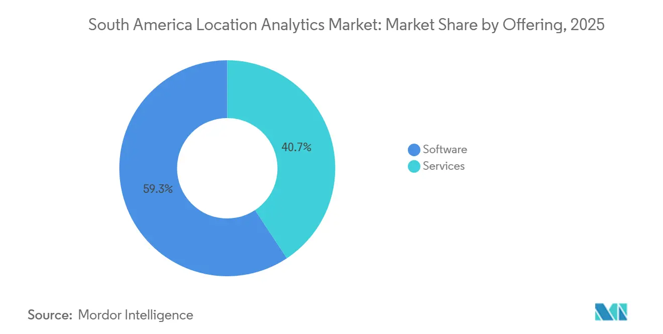
- By offering, software held 59.31% of the South America location analytics market share in 2025, while services are projected to expand at a 16.38% CAGR through 2031.
- By solution and analytics type, reporting and visualization accounted for 28.83% of the South America location analytics market size in 2025, while network and location analytics are projected to expand at a 17.38% CAGR through 2031.
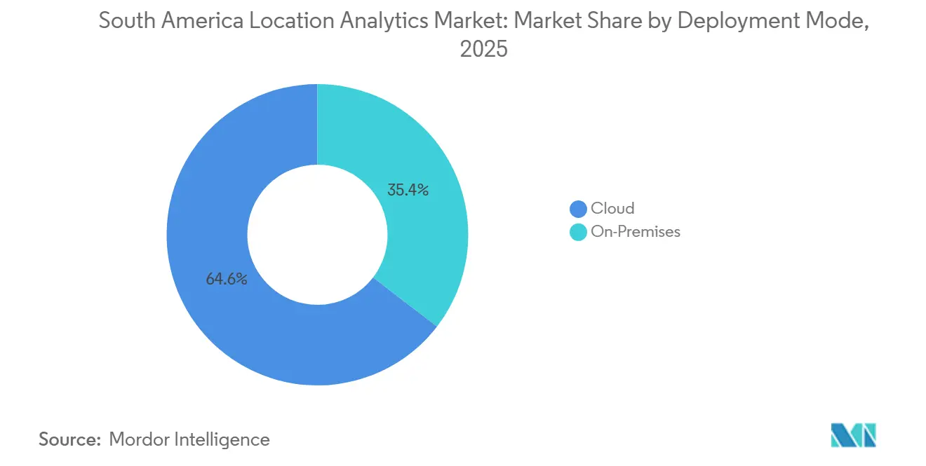
- By deployment mode, cloud held 64.58% of the South America location analytics market share in 2025, and the segment is projected to expand at a CAGR of 16.37% over the forecast period.
- By data and sensing modality, mobile network and device-derived data accounted for 41.82% in 2025, while IoT and sensor-fusion data are projected to expand at a 16.77% CAGR through 2031.
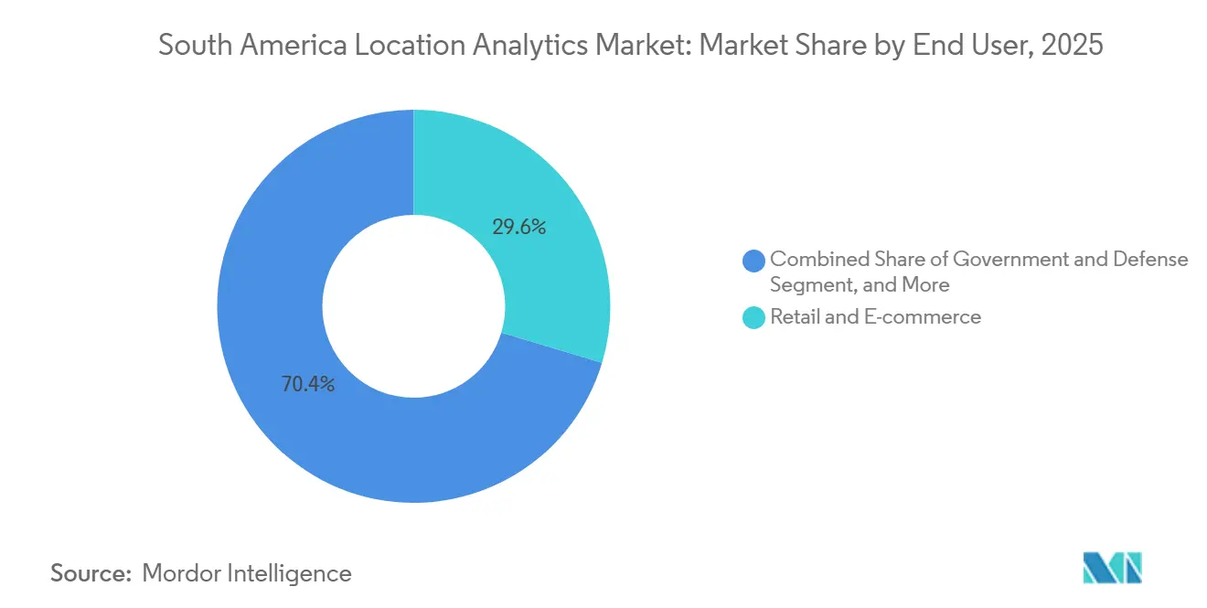
- By end user, retail and e-commerce held 29.64% in 2025, while healthcare and life sciences are projected to expand at a 17.56% CAGR through 2031.
- By organization size, large enterprises accounted for 63.97% in 2025, while small and medium-sized enterprises are projected to expand at a 16.36% CAGR through 2031.
- By geography, Brazil held 55.79% in 2025, while Colombia is projected to expand at a 16.74% CAGR through 2031.
Note: Market size and forecast figures in this report are generated using Mordor Intelligence’s proprietary estimation framework, updated with the latest available data and insights as of January 2026.
South America Location Analytics Market Trends and Insights
Drivers Impact Analysis*
| Driver | (~) % Impact on CAGR Forecast | Geographic Relevance | Impact Timeline |
|---|---|---|---|
| Real-Time Spatial Decision Intelligence | +4.2% | Global, with concentrated gains in Brazil and Chile | Short term (≤ 2 years) |
| Smart-City and Digital Infrastructure Investment | +3.8% | Brazil, Colombia, Argentina | Medium term (2-4 years) |
| Retail, Logistics, and Mobility Optimization | +3.1% | Brazil, Colombia, with spillover to Peru and Chile | Short term (≤ 2 years) |
| Satellite, GNSS, Mobile, and IoT Data Expansion | +2.7% | South America, with early gains in Brazil and Argentina | Medium term (2-4 years) |
| AI-Enabled Geospatial Modeling and Digital Twins | +2.1% | Brazil, Chile, with spillover to Colombia | Medium term (2-4 years) |
| Regional Data Products for Fragmented Addresses and Mobility | +1.2% | Brazil, Colombia, Argentina, and Rest of South America | Long term (≥ 4 years) |
| Source: Mordor Intelligence | |||
Enterprise Shift Toward Real-Time Spatial Decision Intelligence
The South America location analytics market is benefiting as operating teams require current location data rather than daily reports. Logistics, financial services, agribusiness, and public safety teams increasingly use location information when making decisions. Amazon Brazil launched quick-commerce operations across 8 cities in early 2026 and planned a 3-fold expansion by year's end, using location systems that adjust delivery areas through rider positions, inventory, and traffic signals. These operating models create a continuing requirement for data processing instead of a one-time mapping project. Vendors are therefore being assessed on response time, application programming interface performance, and the ability to support changing data feeds. This gives cloud-native platforms an advantage over systems designed mainly for batch processing.
Smart-City and Digital Infrastructure Investment
Smart-city programs and digital infrastructure are increasing the availability of data that can support the South America location analytics market. Rio de Janeiro City Hall announced a USD 550 million investment in the Rio AI City project in June 2026, as part of a program targeting USD 65 billion in investment over the following decade. The program is intended to position Rio de Janeiro among the 10 largest global AI hubs by 2032. Connected infrastructure generates data from sensors, cameras, and vehicles that can be used for urban planning, traffic management, and maintenance. Conecta Infra announced a USD 350 million plan in March 2026 to deploy 6,000 kilometers of fiber connecting Chile and Argentina with Brazil's main digital infrastructure hubs by 2028. These projects extend the networks needed to transmit location data and create demand for ongoing analytics services.
Location-Based Retail, Logistics, and Mobility Optimization
Retailers, distributors, and logistics operators are using the South America location analytics market to improve site decisions and delivery performance. Grupo Petrópolis deployed a routing and fleet-management solution across 2,900 vehicles in Brazil during 2025. The deployment delivered a 98% on-time delivery rate and reduced overtime hours by 9%. Retail location tools are also being used to compare device location data with electronic invoice records at a brand and product level. This can show where a retailer is losing sales by location and can help redirect advertising and inventory decisions. Regional providers are competing for mid-market retail and franchise clients by working with informal address patterns and local mobility behavior. These local data assets are difficult to reproduce from a standard global data set.
Expansion of Satellite, GNSS, Mobile, and IoT-Derived Data
More satellite, positioning, mobile, and sensor data are expanding the information base for the South America location analytics market. Brazil's IBGE increased its Brazilian Continuous Monitoring Network to 153 active GNSS stations in 2025.[1] Brazilian Institute of Geography and Statistics, “IBGE Inaugurates Three New Stations of the Brazilian Continuous Monitoring Network and Publishes Time Series of Geodetic Networks,” IBGE, ibge.gov.br. u-blox extended its PointPerfect Flex GNSS correction service to Argentina and Paraguay in August 2025, providing centimeter-level positioning without additional base stations. These systems support precision agriculture, logistics, surveying, and infrastructure monitoring across remote areas. The expanding supply of sensor readings shifts commercial value from basic data collection to analysis that converts signals into operating actions. Organizations can use these data streams for maintenance, resource planning, crop monitoring, and environmental compliance.
Restraints Impact Analysis*
| Restraint | (~) % Impact on CAGR Forecast | Geographic Relevance | Impact Timeline |
|---|---|---|---|
| High Cost of Geospatial Data and Platform Deployment | -2.4% | South America, most acute in mid-market Brazil and Argentina | Short term (≤ 2 years) |
| Data Privacy, Consent, and Cross-Border Transfer Constraints | -1.9% | Brazil, Colombia, and South America | Medium term (2-4 years) |
| Fragmented Address Standards and Inconsistent Data Quality | -1.1% | Brazil and Rest of South America | Long term (≥ 4 years) |
| Shortage of GIS, Data Science, and Spatial Engineering Talent | -0.8% | South America, most pronounced in smaller economies | Long term (≥ 4 years) |
| Source: Mordor Intelligence | |||
High Cost of Geospatial Data and Platform Deployment
High licensing, integration, and data-acquisition costs limit adoption in the South America location analytics market, especially among mid-sized organizations and public agencies. High-resolution satellite imagery can be costly for commercial users without public programs or co-investment. Integrating spatial systems with enterprise resource planning and customer relationship management platforms also requires specialized software, data remediation, and professional services. These requirements can extend the typical payback period for enterprise deployment to 2-3 years. Currency volatility in Argentina can raise the local-currency cost of USD-denominated licenses during a budget cycle. Consumption-based cloud services provide an alternative to perpetual licenses and can reduce the need to maintain specialized internal teams.
Data Privacy, Consent, and Cross-Border Transfer Constraints
Privacy rules restrict how location data can be collected, processed, and transferred in the South America location analytics market. Brazil's General Data Protection Law treats geolocation data as personal data when it can be tied to an identifiable individual.[2]Autoridade Nacional de Proteção de Dados, “Lei Geral de Proteção de Dados Pessoais,” Government of Brazil, gov.br. The law requires consent, data minimization, and breach notifications in relevant situations. Brazil may impose fines of up to 2% of a company's Brazilian revenue for each violation, capped at BRL 50 million (USD 9.3 million). Colombia's data protection requirements create a similar need for controls over personal location data. The absence of a unified regional framework for cross-border transfers can make closed-loop data systems more attractive than platforms that redistribute aggregated mobility feeds across jurisdictions.
*Our forecasts treat driver/restraint impacts as directional, not additive. The impact forecasts reflect baseline growth, mix effects, and variable interactions.
Segment Analysis
By Offering: Services Adoption Broadens Access Beyond Platform Licensing
Software held 59.31% of the South America location analytics market in 2025. This position reflected established GIS deployments in mapping agencies, telecommunications, oil and gas, financial services, and large enterprises. Long-standing commitments to systems such as Esri ArcGIS and Hexagon ERDAS continued to support software revenue. These platforms remain important where organizations require extensive mapping, data management, and governance capabilities.
Services are projected to expand at a 16.38% CAGR through 2031, the fastest rate within this segmentation. Buyers are increasingly purchasing analytical outcomes and managed delivery rather than only software licenses. The shortage of internal GIS specialists and the maintenance needs of AI-enabled models support this shift. Amazon Brazil's quick-commerce expansion relied on external routing optimization and geospatial modeling support rather than building all capabilities in-house. Foursquare introduced the FSQ Spatial Agent in 2026 to enable natural-language spatial queries without GIS expertise, lowering the barrier to recurring service consumption.


By Solution and Analytics Type: Network Tools Gain Importance as Basic Mapping Becomes Standard
Reporting and visualization accounted for 28.83% of the South America location analytics market in 2025. Enterprise dashboard investment and thematic mapping supported this position in government, logistics, and financial services. Geocoding, reverse geocoding, data integration, extract-transform-load processes, thematic mapping, surface and field analytics, and geovisualization each address distinct stages of the spatial workflow. Basic visualization remains necessary because it makes location data understandable for non-specialist users.
Network and location analytics are projected to expand at a 17.38% CAGR through 2031. Enterprises are moving from descriptive maps toward predictive models for delivery networks, financial contagion corridors, and disease propagation pathways. This change reflects buyers' need to use spatial context directly in planning and operating systems. Mapping features within large business intelligence platforms could reduce the standalone value of visualization-only tools. Brazil's IBGE and SERPRO launched a national program in June 2025 to integrate fragmented public records into predictive analytical platforms. The initiative illustrates the demand for analytical systems that go beyond static reporting.
By Deployment Mode: Cloud Becomes the Preferred Delivery Model
Cloud accounted for 64.58% of the South America location analytics market in 2025, and is expected to grow at a CAGR of 16.37% over the forecast period. The share reflected a clear move away from on-premises installations as regional computing infrastructure expanded across major South American economies. Large geospatial workloads benefit from scalable processing capacity and easier access to cloud-based data services. Alibaba Cloud announced its first Brazilian facility in 2025, adding to the regional infrastructure available for these workloads.
On-premises systems remain relevant for defense, government intelligence, and oil and gas users who handle sensitive location information. Data sovereignty requirements mean that certain workloads cannot move fully to public cloud systems. CARTO and Geoambiente formed an exclusive partnership in Brazil in April 2026 that enables spatial analytics within existing enterprise data warehouses. This approach allows users to access advanced GeoAI functions while maintaining data residency. It also reduces the need to migrate geospatial data between systems. Hybrid deployment is therefore likely to remain part of the South America location analytics market, where compliance needs are strict.
By Data and Sensing Modality: Mobile Signals Lead as Sensor Fusion Expands
Mobile network and device-derived data held 41.82% of the South America location analytics market in 2025. High smartphone use and dense mobility signals in Brazil, Colombia, and Argentina supported the segment. GNSS and satellite-derived data remain important for agriculture and infrastructure monitoring. Wi-Fi and Bluetooth Low Energy data also support indoor navigation and foot-traffic analysis in retail and logistics facilities.
IoT and sensor fusion data are projected to grow at a 16.77% CAGR through 2031. Connected infrastructure, smart meters, and agricultural equipment are increasing the number of georeferenced data points available to users. Hexagon began aerial 3D mapping for its Green Cubes initiative with Vale in April 2026, using LiDAR and imagery around Brazilian mining assets. Combining satellite imagery, airborne and terrestrial LiDAR, camera traps, and acoustic sensors supports detailed environmental monitoring. Such combinations can help mining, energy, and infrastructure organizations manage compliance and operating risks.
By End User: Retail Leads Current Demand While Health Care Expands Faster
Retail and e-commerce accounted for 29.64% of the South America location analytics market size in 2025. The segment uses trade-area analysis, store placement, customer targeting, and last-mile routing. Brazil's e-commerce logistics network supports this use of location information across large and varied urban areas. Retail buyers also use local data to identify gaps between customer demand, store coverage, and inventory availability.
Health care and life sciences are projected to expand at a 17.56% CAGR through 2031. Health systems can use geospatial data to plan facilities, model epidemic corridors, and route mobile services across unequal care geographies. The Pan American Health Organization has highlighted digital health as a regional priority through its Digital Health Strategy for the Americas 2023-2030. Public agencies and health technology organizations are combining population density data with epidemiological records to identify areas where primary care capacity is needed. This use case positions location analytics as a planning tool for access-to-care and commercial operations.

By Organization Size: Large Enterprises Fund Current Demand While SMEs Enter More Easily
Large enterprises held 63.97% of the South America location analytics market in 2025. Large organizations can fund enterprise licenses, custom data integration, and professional services across multiple sites. Telecommunications, mining, oil and gas, financial services, and industrial groups have operational needs that support this investment. Their existing data environments also make wide-scale spatial analysis more valuable.
Small and medium-sized enterprises are projected to expand at a 16.36% CAGR through 2031. Subscription pricing and AI-assisted tools can reduce the cost and technical complexity that previously limited smaller users. Foursquare offers FSQ Spatial Desktop to individual practitioners for USD 25 per month, illustrating the availability of smaller analytical modules. Brazilian providers Kognita, Cognatis, and Datlo use subscription models for retail chains and franchise networks. An open geographic data infrastructure can also reduce data-acquisition costs for smaller buyers.
Geography Analysis
Brazil accounted for 55.79% of the South America location analytics market in 2025. Its position reflects the scale of enterprise investment, its established GIS ecosystem, and national spatial data programs. IBGE and SERPRO launched the National Program of Geoscientific and Statistical Governance and Intelligence in June 2025. The program is building platforms that combine fragmented government geospatial and statistical records. Brazil also has competition between global platforms and local specialists, with the latter having strengths in informal settlement mapping and local mobility data.
Colombia is projected to expand at a 16.74% CAGR through 2031, the fastest rate among the countries covered. The Ministry of ICT committed COP 1.4 trillion (USD 340 million) in May 2026 to expand the fiber backbone into the Amazon and Putumayo departments. The project is intended to extend connectivity to 227,000 people. Planet expanded its multi-year arrangement with Instituto Geográfico Agustín Codazzi in July 2025 to provide satellite data and AI-enabled analytics for roads and buildings. Improved connectivity and national mapping capabilities expand the data infrastructure available for planning, land use, and risk management.
Argentina and the Rest of South America add demand through agriculture technology, environmental monitoring, energy, and logistics. u-blox expanded centimeter-level GNSS correction coverage to Argentina and Paraguay in August 2025. The service supports precision agriculture and fleet activity where conventional real-time kinematic base-station networks are not viable. Chile's solar development and Argentina's agricultural technology sector generate valuable sensor and satellite datasets. Paraguay is progressing its spatial data infrastructure through the GeoSUR network. The EU-LAC Aviation Partnership Project identified Lima, Bogotá, and Brasília as candidate sites for satellite-based augmentation system demonstrations in 2025. These developments can improve location accuracy for analytics platforms across South America.
Competitive Landscape
The South America location analytics market is moderately fragmented. Environmental Systems Research Institute, HERE Global B.V., and Hexagon AB have strong recognition among large enterprises and government users. AI-focused specialists, satellite intelligence providers, and regional geomarketing platforms compete in mid-market and sector-specific applications. Large providers focus on platform integration and adding AI capabilities to established products. Local providers compete on country-specific data, address interpretation, and pricing suited to smaller buyers across the South America location analytics market.
HERE Technologies and Esri signed a 3-year agreement in July 2026 to develop AI-enabled location analytics and workflow capabilities.[3]HERE Technologies, “HERE Technologies and Esri Partner to Develop Location Analytics to Support AI Adoption,” HERE Technologies, here.com. The agreement combines HERE map, traffic, and mobility data with Esri ArcGIS for transportation, logistics, public sector, and automotive users. CARTO's April 2026 agreement with Geoambiente gives Brazilian enterprises access to spatial analytics inside their existing cloud data warehouses. This zero-extract-transform-load design responds to data residency and procurement needs. Foursquare's 2026 Spatial Agent is another example of a strategy to bring complex spatial analysis to business users without GIS training.
Satellite intelligence providers are also strengthening their regional positions. Satellogic secured a contract worth more than USD 18 million in May 2026 for persistent, high-frequency Earth observation monitoring. It also holds a multi-year agreement with the Brazilian Air Force for low-latency sub-meter imagery. Hexagon acquired ITRES Research Limited in June 2026 to add airborne hyperspectral and thermal imaging systems to its portfolio. Health care location analytics and precision agriculture modeling remain areas where region-specific data and specialized platforms are limited.
South America Location Analytics Industry Leaders
Environmental Systems Research Institute, Inc.
HERE Global B.V.
Trimble Inc.
Hexagon AB
TomTom N.V.
- *Disclaimer: Major Players sorted in no particular order

Recent Industry Developments
- August 2026: Esri announced at the 2026 Esri User Conference a significant enhancement to its World Imagery basemap through a new partnership with Airbus, providing ArcGIS users with high-resolution imagery coverage for 2,000 cities worldwide, including key South American urban centers. The expanded basemap directly upgraded the foundational data layer available to location analytics workflows running on the ArcGIS platform, with further agreements with Nearmap and Vantor adding metropolitan-area imagery refreshes at 15 cm to 20 cm resolution.
- July 2026: HERE Technologies and Esri signed a 3-year agreement to jointly develop AI-enabled location-based analytics and visualization capabilities for agentic workflows, building on a partnership of more than 20 years. The collaboration combines HERE's map content, traffic, and mobility data with Esri's ArcGIS platform, targeting engineering teams and AI systems across transportation, logistics, public sector, and automotive industries that require live geospatial data integrated into operational decision systems.
- June 2026: Rio de Janeiro City Hall and Elea Data Centers announced a USD 550 million investment in Elea's digital infrastructure platform as part of the Rio AI City project, within a broader program targeting total investments of USD 65 billion over the next decade. The initiative aims to position Rio de Janeiro among the 10 largest global AI hubs by 2032, creating sustained downstream demand for urban spatial analytics and digital-twin applications across the city.
- June 2026: Hexagon AB acquired ITRES Research Limited, a Calgary-based provider of high-performance airborne hyperspectral and thermal imaging systems, strengthening Hexagon's multi-sensor geospatial data capture capability. ITRES is expected to generate revenue of EUR 13 million (USD 14.7 million) in 2026 and will be reported within Hexagon's Infrastructure and Geospatial Business Area, with direct applications in environmental monitoring, mining reclamation, and infrastructure inspection workflows across South America.


South America Location Analytics Market Report Scope
The South America Location Analytics Market comprises the software and services that organizations use to collect, integrate, process, analyze, visualize, and derive actionable insights from location-based and spatial data. The market includes technologies that combine geographic information with business, operational, demographic, mobility, and sensor-derived datasets to support applications such as site selection, asset and fleet management, route optimization, spatial intelligence, risk assessment, network planning, customer analysis, and operational decision-making.
The South America Location Analytics Report is Segmented by Offering (Software and Services), Solution and Analytics Type (Data Integration and ETL, Geocoding and Reverse Geocoding, Reporting and Visualization, Thematic Mapping and Spatial Analysis, Network and Location Analytics, Surface and Field Analytics, and Geovisualization), Deployment Mode (Cloud and On-Premises), Data and Sensing Modality (GNSS and Satellite-Derived Location Data, Mobile Network and Device-Derived Data, Wi-Fi and BLE-Derived Data, and IoT and Sensor-Fusion Data), End User (Retail and E-Commerce, Automotive, Transportation, and Logistics, BFSI, Government and Defense, Telecommunications, Healthcare and Life Sciences, Manufacturing and Industrial, and Other End User Industries), Organization Size (Large Enterprises, and Small and Medium-Sized Enterprises), and Geography (Brazil, Argentina, Colombia, and Rest of South America). The Market Forecasts are Provided in Terms of Value (USD).
By Offering
| Software |
| Services |
By Solution and Analytics Type
| Data Integration and ETL |
| Geocoding and Reverse Geocoding |
| Reporting and Visualization |
| Thematic Mapping and Spatial Analysis |
| Network and Location Analytics |
| Surface and Field Analytics |
| Geovisualization |
By Deployment Mode
| Cloud |
| On-Premises |
By Data and Sensing Modality
| GNSS and Satellite-Derived Location Data |
| Mobile Network and Device-Derived Data |
| Wi-Fi and BLE-Derived Data |
| IoT and Sensor-Fusion Data |
By End User
| Retail and E-Commerce |
| Automotive, Transportation, and Logistics |
| BFSI |
| Government and Defense |
| Telecommunications |
| Healthcare and Life Sciences |
| Manufacturing and Industrial |
| Other End User Industries |
By Organization Size
| Large Enterprises |
| Small and Medium-Sized Enterprises |
By Geography
| Brazil |
| Argentina |
| Colombia |
| Rest of South America |
| By Offering | Software |
| Services | |
| By Solution and Analytics Type | Data Integration and ETL |
| Geocoding and Reverse Geocoding | |
| Reporting and Visualization | |
| Thematic Mapping and Spatial Analysis | |
| Network and Location Analytics | |
| Surface and Field Analytics | |
| Geovisualization | |
| By Deployment Mode | Cloud |
| On-Premises | |
| By Data and Sensing Modality | GNSS and Satellite-Derived Location Data |
| Mobile Network and Device-Derived Data | |
| Wi-Fi and BLE-Derived Data | |
| IoT and Sensor-Fusion Data | |
| By End User | Retail and E-Commerce |
| Automotive, Transportation, and Logistics | |
| BFSI | |
| Government and Defense | |
| Telecommunications | |
| Healthcare and Life Sciences | |
| Manufacturing and Industrial | |
| Other End User Industries | |
| By Organization Size | Large Enterprises |
| Small and Medium-Sized Enterprises | |
| By Geography | Brazil |
| Argentina | |
| Colombia | |
| Rest of South America |


Key Questions Answered in the Report
What is the South America location analytics market size?
The South America location analytics market size is estimated at USD 324.91 million in 2026 and is forecast to reach USD 681.86 million by 2031 at a 15.98% CAGR. Demand is supported by cloud delivery, operating use cases, and expanding sources of location data across the region.
Which offering is expanding fastest in South America location analytics?
Services are projected to expand at a 16.38% CAGR through 2031 as users seek managed analytical outcomes and help with complex data operations. The segment responds to scarce in-house GIS skills and the ongoing maintenance requirements of advanced spatial models, data pipelines, and location-specific operating workflows.
Why is cloud deployment important for location analytics in South America?
Cloud held 64.58% in 2025 because scalable computing can process extensive geospatial workloads and support connected data sources. On-premises systems still serve users that need strict control over sensitive geospatial assets.
Which end-user segment is projected to expand fastest?
Health care and life sciences are projected to expand at a 17.56% CAGR through 2031, supported by facility planning, epidemic modeling, and mobile health routing needs. These applications help organizations address uneven access to care across large and varied territories.
Which country is expected to lead regional expansion?
Colombia is projected to expand at a 16.74% CAGR through 2031, supported by connectivity investment and national satellite analytics activity. Fiber expansion and satellite-based change detection are strengthening the location data foundation for public planning and commercial activity.
What limits adoption of location analytics systems?
Platform and data costs, privacy requirements, uneven address quality, and a shortage of GIS and spatial engineering skills can delay wider adoption. Buyers may also need data remediation, reliable local reference data, and professional services before a system can support operational decisions across several connected business functions.
Page last updated on: