Market Trends of ASEAN Satellite Imagery Services Industry
Military and Defense to drive the market growth
- Satellite imagery enhances defense and security programs by enabling local governments to understand situations and programs better to protect lives and property and enhance the economic stability of the nation. Threats such as terrorism and information attacks on critical infrastructure, potential use of weapons of mass destruction, and the spread of infectious diseases cause massive casualties and disruption to a country. Satellite images capture essential information about such criminal activities across the region.
- Satellite imagery increases a country's crime-fighting capabilities due to the efficiency and speed of data retrieval and crime analysis. High-resolution satellite imagery and GIS (geographic information system) data are witnessing a surge in demand as they allow analysts to identify hot spots and patterns for crime mapping.
- Demands for mapping applications have become necessary in law enforcement agencies worldwide. Thus, satellite imaging service providers are striving to provide geospatial products and services for government agencies for a wide range of defense and security mapping applications. Satellite imaging experts assist in feature extraction and manipulation of satellite image data through advanced remote sensing techniques.
- Satellite imagery services are critical to Homeland Security because they enable supervisors and emergency personnel to integrate multiple information types into a common visual application. Deep learning processing, such as convolutional neural network (CNN) algorithms, is suitable for temporal satellite imagery analysis and provides timely results. Advancements such as 3D terrain visualization models for geographical areas assist in flight training, battlefield management, mission rehearsal, research, and other activities.
- This year, the 16th Edition of the Langkawi International Maritime and Aerospace Exhibition (LIMA) conference officially commenced in Langkawi, Malaysia. The exhibition was focused on defense and military applications of aerospace and maritime, highlighting space technology development and innovation. The Langkawi International Space Forum (LISF) was introduced as part of the Ministry of Science, Technology, and Innovation of Malaysia (MOSTI) 's efforts to increase awareness of space within the region. The government of Malaysia supported the Space Industry Strategic Plan 2030 (SISP) and the Malaysia Space Exploration 2030 (MSE) blueprint to promote the growth of the space sector in Malaysia with a contribution of 1% of GDP in 2030, projected to be MYR 10 billion (USD 2.4 billion).
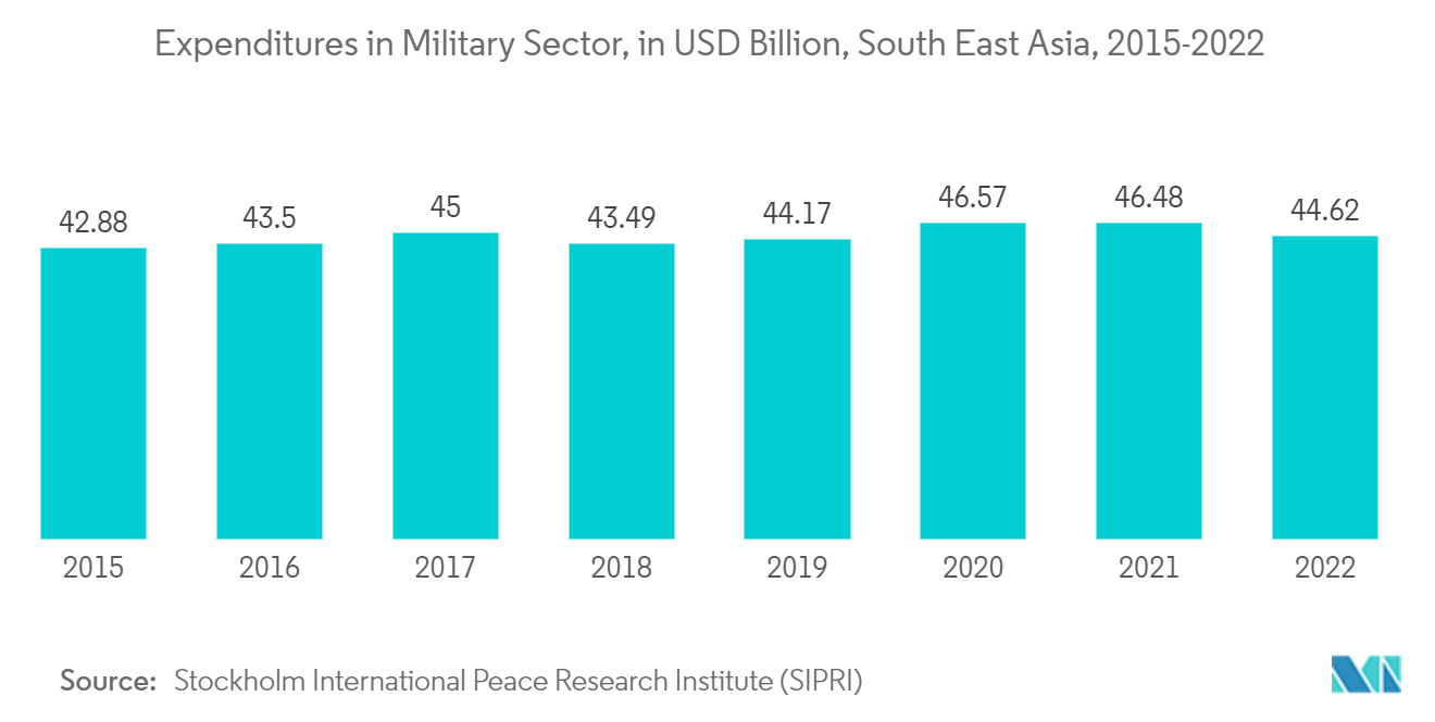
- Moreover, according to the Stockholm International Peace Research Institute (SIPRI), military expenditure across the Southeast Asia region significantly increased from USD 20.3 billion in 2020 to USD 4.62 billion in 2022. Furthermore, Singapore's government spending on the military was significant among other countries in the region registering around 16.91% in 2022. Such significant spending among countries in the region would substantially enhance the sector's adoption of satellite imagery services.
- Overall, the rising demand for satellite imagery in military and defense for intelligence gathering, as well as the utilization of high-resolution images to access valuable information about enemy troop movements, military installations, and other strategic assets, is expected to propel the market growth during the forecast period.
Understand The Key Trends Shaping This Market
Download Sample
Thailand is Expected to propel the market growth
- The ASEAN nations are witnessing remarkable growth in space technology for applications such as disaster management, agriculture, and tourism. Advancements in Earth observation satellites are helping the ASEAN nations better monitor disputed areas and handle conflicts through accurate mapping.
- Vietnam is among the significant spenders in space programs within the ASEAN group, along with Indonesia, Thailand, and Malaysia. These countries are spending vast amounts of money on developing local space programs. The Indonesian Space Act focuses on space science, remote sensing, developing aerospace technology, and launching and commercializing space activities to attain self-sufficiency in the space sector.
- Thailand is another major contributor to the ASEAN space program concentrated on space communications applications, meteorological satellites, remote-sensing satellites, and space technology. The country has developed its space program with space powers like the US, China, and Japan. It is also one of the founding members of the China-led Asia-Pacific Space Cooperation Organization (APSCO).
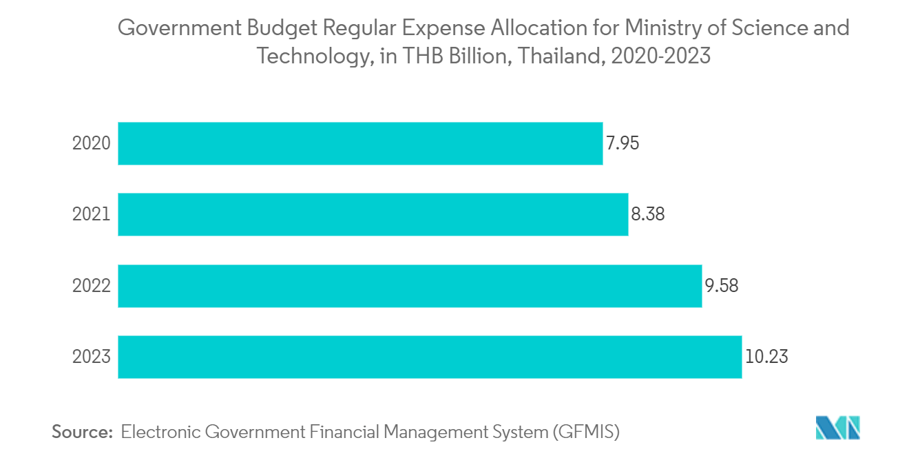
- Moreover, according to the Electronic Government Financial Management System (GFMIS), Thailand's government budget allocation under the regular expenses section for the Ministry of Science and Technology is witnessing significant growth in the allocations. The government allocated THB 10.23 billion (USD 306.9 million) for regular expenses to the Ministry of Science and Technology in FY 2023, a 6.78% increase in budget from the previous year. Such a higher budget allocation to the Ministry of Science and Technology might indicate a commitment to advancing technology and innovation. This can lead to increased investments in satellite technology and infrastructure, which are essential for satellite imagery services.
- Last year, Thailand announced its plans to launch its primary satellite, Theos-2, with advanced capabilities to signify Thailand's commitment to space technology and national development. This satellite is an upgrade to the nation's earlier satellite, THEOS-1 (Thaichote), and can capture high-resolution imagery with a 50cm spatial resolution. The satellite imagery services are anticipated to support agriculture, disaster management, urban planning, and economic development.
- Thailand's announcement of a high-resolution imagery satellite marks a recognizable step in ASEAN's rapidly growing footprint in space dominance. With advanced high-resolution imaging capabilities, the satellite aligns itself with several crucial missions, including enhancing national security through monitoring, Disaster Management, and Economic Development.
- Thai Union Group PCL, a high-quality, healthy, tasty, and innovative seafood products provider, began piloting satellite imaging for shrimp farming operations in collaboration with Sea Warden and Wholechain last year. Thai Union is regarded as one of the largest producers of shelf-stable tuna products. The Thai Union aims to promote innovative technologies for sustainable seafood production. The data collected through satellite imaging, integrated with traceability technology, ensures a sustainable farming practice through insights into shrimp populations, farm health, and contamination. Such developments and initiatives are anticipated to strengthen Thailand's ASEAN satellite imagery market position.
Get Analysis on Important Geographic Markets
Download Sample
