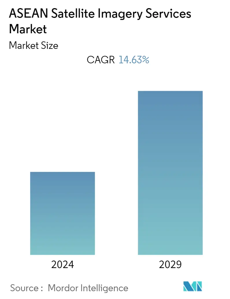
Market Size of ASEAN Satellite Imagery Services Industry
| Study Period | 2019 - 2029 |
| Base Year For Estimation | 2023 |
| Forecast Data Period | 2024 - 2029 |
| Historical Data Period | 2019 - 2022 |
| CAGR | 14.63 % |
| Market Concentration | Low |
Major Players
*Disclaimer: Major Players sorted in no particular order |
Need a report that reflects how COVID-19 has impacted this market and its growth?
ASEAN Satellite Imagery Services Market Analysis
The ASEAN satellite imagery services market was valued at USD 0.10 billion in the previous year and is expected to register a CAGR of 14.63%, reaching USD 0.23 billion by the next five years.
- The ASEAN satellite imagery services market. Benefits of satellite imageries in a wide range of applications such as monitoring large areas of dense forests, analyzing comparisons of land covers at different times, classifying the vegetation through spectral and texture analyses, and threat monitoring in military and defense sectors, bolstering the growth of the ASEAN satellite imagery services market growth.
- Growing demand for images with different spatial resolutions, from low to high, for use in environmental assessment, mapping, forestry management, disaster assessment, and urban monitoring bolstered the demand for low-resolution Satellite images. High-resolution imagery is growing for detailed information on small objects such as buildings, streets, rivers, and trees, which are useful for applications such as transportation network mapping, disaster management, urban planning, and farming.
- In ASEAN nations, Satellite images are utilized to study various elevations and topographical features across geographical areas. Satellite imagery helps to analyze agricultural fields where farmers can monitor their crops' health. Researchers are scientists across the ASEAN nation, adopting satellite imagery and data to monitor environmental changes to forecast weather or natural disasters. The rapid development of intelligent cities in Jakarta (Indonesia), Hanoi (Vietnam), Singapore (Singapore), and Kuala Lumpur (Malaysia), among others, have accelerated the demand for satellite imagery services for city planners to plan new residential areas for communities.
- Satellite imagery services are increasingly used in transportation, studying traffic, and facilitating the planning of new road networks in many ASEAN nations. The telecom sector is also witnessing rapid growth in satellite imagery services as broadband connectivity for users on airplanes, ships, and vehicles in stationary and moving locations is gaining a solid foothold. Requirements for constant connectivity throughout big cities and sparsely populated regions are surging the demand for research utilizing data from satellite imagery.
- However, regulatory hindrances and complex licensing procedures can hamper the growth of satellite imagery services in the ASEAN region. Different countries within ASEAN may have varying regulations and requirements for satellite imagery, making it difficult for companies to operate consistently across borders. Further, in some ASEAN countries, limited infrastructure, particularly in rural areas, can restrict the use and distribution of satellite imagery services. This limitation can affect the accessibility of such services to a wider audience.
- Space assets are crucial in enhancing monitoring and analysis across various areas post-COVID-19. Satellite imagery and the global positioning system technology assist in post-pandemic planning and the distribution of healthcare solutions in many low and middle-income countries. Telemedicine has served an essential role in mitigating the pandemic by providing constant medical care even in remote locations. In the space sector, satellite imagery and satellite-based communication have been at the forefront of enhancing telemedicine and expanding healthcare to rural and remote areas across many ASEAN countries.
