Market Trends of Aerial Imaging Industry
Government to be the Largest End-User for Aerial Imaging
- Aerial imaging has become vital for various municipal, state, and federal government planning applications. Aerial photography became an integral aspect of the mapmaking process. Aerial images reflect a location's physical and cultural environment at a particular moment. When properly understood, these aerial photographs give geographers, historians, ecologists, geologists, urban planners, archaeologists, and other experts a graphical foundation that is frequently important to their research. Lawyers increasingly use aerial photography to decide matters involving property disputes, riparian rights, and transportation rights-of-way. Recently, genealogists have employed aerial photography to discover and find ancestral locations.
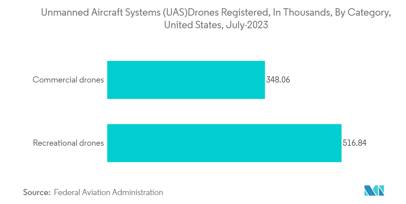
- Government drone use is quickly rising regarding the number of departments with drone projects and applications. Ambitious government organizations and departments are experimenting with new job areas, from transportation and public works to planning and environmental services.
- The US government has experimented with new weaponry that may be deployed on the battlefield. Gaining an edge on the battlefield is crucial to a war's survival and success. Uncrewed aerial vehicles (UAVs) have been the most significant invention in military conflict in recent decades, if not the preceding century.
- For example, the United States Geological Survey's Upper Midwest Environmental Sciences Center has recently partnered with the Bureau of Ocean Energy Management and the US Fish and Wildlife Service. The Vision Group at the International Computer Science Institute at the University of California, Berkeley, will create deep learning algorithms and tools for the automatic identification, enumeration, categorization, and annotation of sea ducks and other marine creatures from digital aerial imagery.
- Most individuals utilize aerial images, whether they realize it or not. Aerial imagery may help individuals and organizations of all sizes and sectors save time and money, from basic applications like Google Images or Google Earth to complicated applications like police agencies using it to reduce crime.
- Airborne waterfowl population surveys can influence harvest and other regulatory decisions, environmental evaluations, and impact estimates of prospective wildlife exposure to offshore energy development projects in the United States. High-resolution digital images collected during aircraft surveys of the Atlantic Outer Continental Shelf and the Great Lakes will provide data for algorithm development and baseline information on animal distributions and abundance.
- Aerial pictures can help governments, professional response and recovery organizations, communities, and people anticipate, respond to, and recover from the consequences of expected imminent or real hazard occurrences or circumstances. The increasing aerial photography usage in many government sectors has increased the demand for aerial pictures worldwide.
Understand The Key Trends Shaping This Market
Download Sample
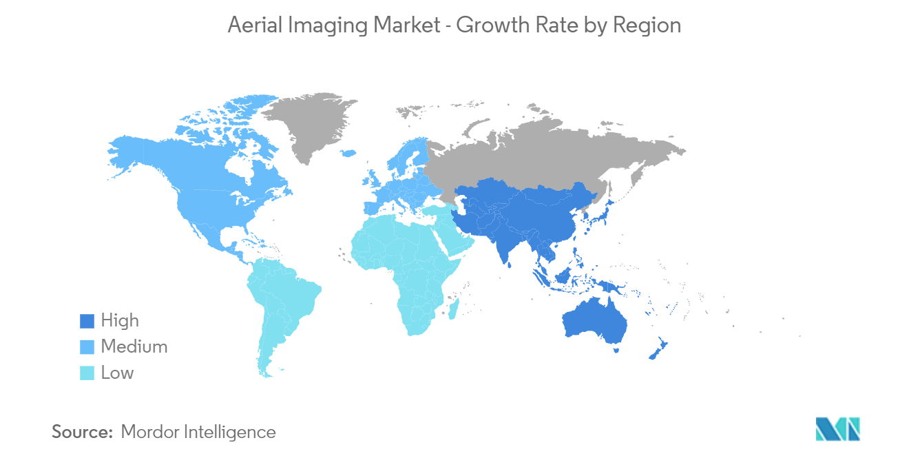
North America to Hold Significant Market Share
- North America is one of the major investors and adopters of the studied market due to the high level of research done by the regional companies and the increasing adoption of the technologies among the regional end-user industries.
- Aerial imaging extracts information on land cover, vegetation, soil, and geology maps using spatial data captured from orthographic images. Aerial imaging is also used in government-based applications such as inland & property information, archaeology, environment studies, disaster & emergency response management, etc. Aerial imaging is then used in developing plans, maps, & forecasts that are crucial for accurately presenting the Earth's surface. Also, aerial imaging is gaining prominence among engineers, planners, and developers in land mapping and development.
- Market expansion is the primary factor driving the increased adoption of aerial imaging platforms in disaster management, military, forestry, and urban planning applications. The use of Aerial imaging and mapping platforms is growing among urban planners in road planning and real estate management and is used in land use calculations. The region exhibits a strong uptake of aerial imaging platforms due to major aerial imaging solution providers focusing on new product developments powered by AI and machine learning technologies.
- In addition, agriculture in North America has become chiefly industrialized and reliant on an integrated system of supporting agribusinesses; however, original traditions are still practiced in Mexico. Most farmers and ranchers in the United States and Canada rely primarily on technology. Technology companies have been working to provide insights to farmers through multiple data sources, including sensors, in-field cameras, aerial imagery gathered by drones and airplanes, and satellite imagery data. These imagery data sources require powerful computing resources, massive data storage capabilities, and time to generate insights.
- Moreover, the demand for aerial imaging in the region's construction activity is increasing continuously. For example, with drone technology, field engineers can track job progress and monitor these inconsistencies more efficiently. According to the research, 48% of all rework on U.S. construction sites is done by hand, and both of these issues can be mitigated with drone technology.
- Additionally, increasing government spending on the construction industry; for instance, in December 2021, with the passing of President Biden's historic infrastructure bill, the construction industry braced for a substantial boost in investment. Contractors and surveyors are expected to be in great demand to oversee various civil construction projects around the country, with USD 110 billion set aside for roads, bridges, and other significant infrastructure projects. Factors such as the growing use of technologies and the number of government construction projects that have boosted the demand for the benefits of technologies for the inspection, monitoring, and surveillance of the site area are critical reasons for the market's growth.
Get Analysis on Important Geographic Markets
Download Sample
