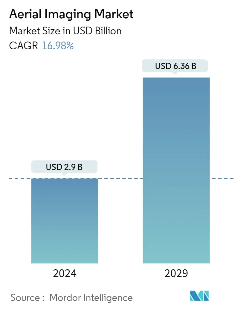
Market Size of Aerial Imaging Industry
| Study Period | 2019 - 2029 |
| Market Size (2024) | USD 2.9 Billion |
| Market Size (2029) | USD 6.36 Billion |
| CAGR (2024 - 2029) | 16.98 % |
| Fastest Growing Market | Asia Pacific |
| Largest Market | North America |
Major Players
*Disclaimer: Major Players sorted in no particular order |
Need a report that reflects how COVID-19 has impacted this market and its growth?
Aerial Imaging Market Analysis
The Aerial Imaging Market size is estimated at USD 2.9 billion in 2024, and is expected to reach USD 6.36 billion by 2029, growing at a CAGR of 16.98% during the forecast period (2024-2029).
Aerial imaging and its evolution into video imagery have been captured using various small aerial platforms for over three decades. Small-scale platforms, such as radio-controlled model aircraft, helicopters that use small 35 mm SLR, and light-weighted video cameras have been used to acquire color, panchromatic, color infrared (CIR), and multispectral aerial photography for a wide range of applications.
- The market has been augmented by the technology development of ready-to-fly (RTF) devices, soft-copy photogrammetry software, low-cost digital cameras, image processing, GPS, thermal, multispectral, hyperspectral, and LiDAR sensors. UAVs have become a sophisticated means of acquiring high-resolution photographic and 4K video datasets for small-area coverage studies.
- Aerial imaging uses GPS, which aids in the precise location. For instance, farmers use GPS targeting to monitor the health of the crops, identify problem areas and spray fertilizer. Energy and power site management benefits from the precision of aerial imaging, as it gets repaired from weather damages and can be targeted more accurately.
- The COVID-19 pandemic has led to increased demand for aerial imagery, including studying the economic impact of the virus and conducting remote monitoring of infrastructure and facilities. The demand increased from various industries, including government, energy, power, oil, and gas. Also, the imagery monitored supply chain situations during the pandemic's peak.
- Although the trend of drone surveying is already becoming mainstream, the COVID-19 pandemic tipped the scale in its favor substantially. UAVs have become a go-to technology during the COVID-19 pandemic because they can accomplish tasks without contact. They have played a crucial role in surveying and mapping areas where hospitals and COVID-19 test centers can be built and monitoring such sites. Police departments also use maps that are being created using aerial imagery. The department uses it for the movement of essential items, placing physical distancing markers, workforce allocation, deciding where to set up isolation centers, marking nearby hospitals and police stations from hotspots, and the shortest routes for easy movement in case of an emergency.
