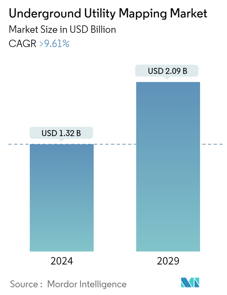
Market Size of Underground Utility Mapping Industry
| Study Period | 2019 - 2029 |
| Market Size (2024) | USD 1.32 Billion |
| Market Size (2029) | USD 2.09 Billion |
| CAGR (2024 - 2029) | > 9.61 % |
| Fastest Growing Market | Asia Pacific |
| Largest Market | North America |
Major Players
*Disclaimer: Major Players sorted in no particular order |
Need a report that reflects how COVID-19 has impacted this market and its growth?
Underground Utility Mapping Market Analysis
The Underground Utility Mapping Market size is estimated at USD 1.32 billion in 2024, and is expected to reach USD 2.09 billion by 2029, growing at a CAGR of greater than 9.61% during the forecast period (2024-2029).
Underground utility mappings like pipework or underground electric wires determine the utility location. Underground utility mapping is essential to civil engineering because it saves time and money on costly repairs caused by striking utilities. Project planners can accurately plan costs for work to be done with the help of an accurate utility map. However, surveyors face record accuracy and mapping challenges, as mapping the location of hidden utility objects is an inherently difficult task.
- Over the last few years, the subsurface utility engineering (SUE) industry has developed novel approaches to mapping underground utility infrastructure. Geophysical technologies such as electromagnetic locators and ground-penetrating radars are used with non-technical methods such as historical records to gather sufficient subsurface infrastructure information.
- With the proliferation of smartphones in recent years, vendors are seizing the opportunity to create app-based mapping solutions to aid engineers in their work. For example, Radiodetection, a manufacturer of underground utility mapping tools, released an Android mapping app compatible with the RF marker locator range and the cable, pipe, or RF marker range. The app uses Bluetooth connectivity to create a real-time map of buried utilities.
- The combination of emerging technologies with utility maps is revolutionizing the underground utility mapping market by improving the accuracy, efficiency, and safety of exploration activities. These advancements enable exploration teams to overcome challenges associated with underground infrastructure, optimize exploration routes, and minimize risks, ultimately driving growth and innovation in the market.
- Technological advancements have led to the development of sophisticated detection applications that are more accessible to many users. These applications may include software solutions, mobile apps, and handheld devices equipped with sensors capable of detecting underground utilities.
- High maintenance costs often accompany high upfront investment requirements for mapping tools. This can deter potential customers, especially smaller organizations or those with limited budgets, from adopting underground utility mapping solutions.
- The COVID-19 pandemic accelerated the adoption of digital technologies, including underground utility mapping solutions. Organizations recognized the importance of digitizing and automating processes to improve efficiency, reduce reliance on manual labor, and mitigate future disruption.
