Market Size of Mobile Mapping Systems Industry
| Study Period | 2019 - 2029 |
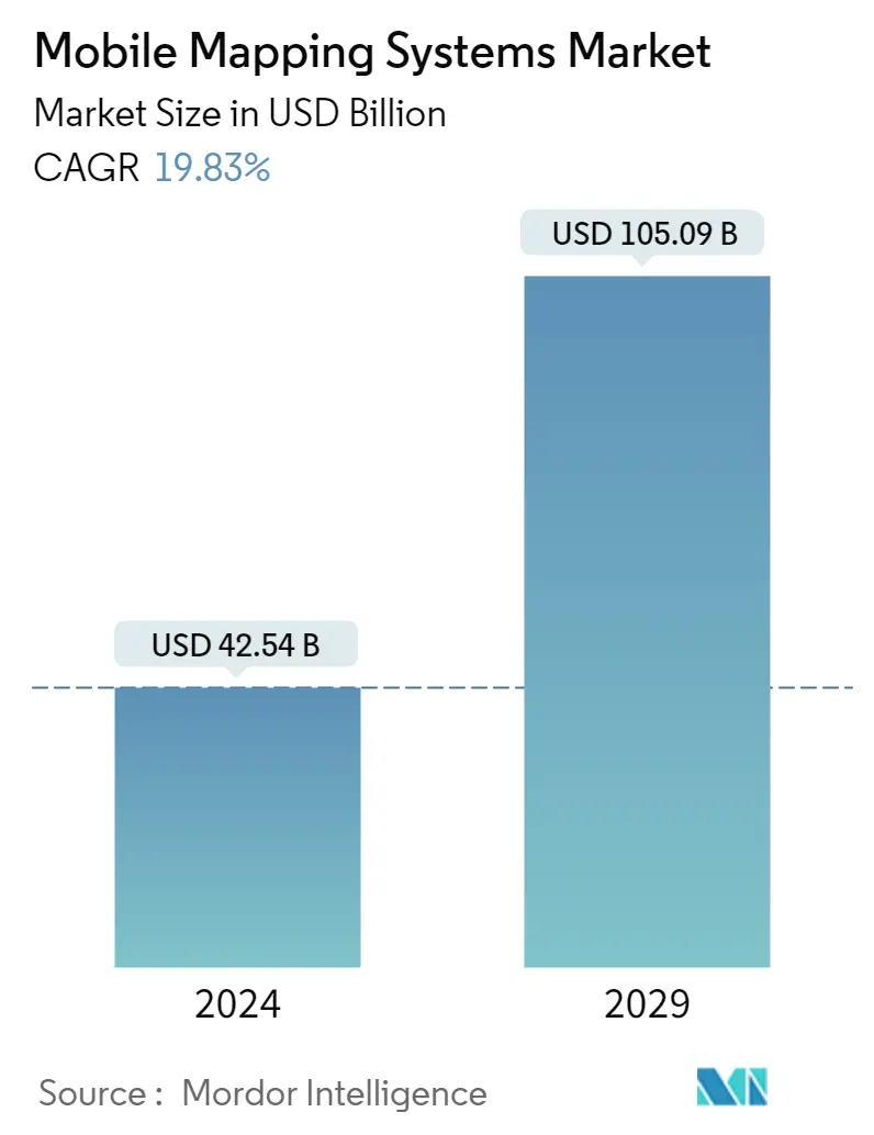
| Market Size (2024) | USD 42.54 Billion |
| Market Size (2029) | USD 105.09 Billion |
| CAGR (2024 - 2029) | 19.83 % |
| Fastest Growing Market | Asia-Pacific |
| Largest Market | North America |
Major Players
*Disclaimer: Major Players sorted in no particular order |
Need a report that reflects how COVID-19 has impacted this market and its growth?
Mobile Mapping Systems Market Analysis
The Mobile Mapping Systems Market size is estimated at USD 42.54 billion in 2024, and is expected to reach USD 105.09 billion by 2029, growing at a CAGR of 19.83% during the forecast period (2024-2029).
The rapid acceptance of satellite mapping technology and its seamless integration into smartphones and Internet of Things (IoT)-connected devices are driving the market's growth.
Smart cities rapidly expanded due to increased urbanization and supported government initiatives worldwide. A smart city can only exist with a 3D map. With the support of 3D city modeling, autonomous navigation, traffic, disaster management, digitizing roadway property, and pollution reduction, mobile mapping technology for smart cities aims to improve quality of life by optimizing resources and maintaining sustainability. Smartphone and internet usage played critical roles in data management and access.
Further, mobile navigation geographic information system (GIS) for environmental monitoring is increasingly used in monitoring the environment. Environmental researchers are employing mobile mapping GIS tools to help with storm and hurricane forecasting and monitoring. The NASA-funded research project on ecological monitoring and natural resource management drives revenue growth in the mobile mapping sector.
Mobile mapping systems are used for various applications, including developing indoor maps for pedestrian navigation, high-definition (HD) maps for autonomous vehicles, asset and infrastructure management, ariel surveys, pipeline surveys, hydrographic surveys, dredging, and offshore positioning/drilling operations.
The emergence of on-demand deployment systems is an inflection point in the mobile mapping market, as high levels of flexibility and accuracy at low initial costs are offered (users are charged on a monthly/quarterly basis). Companies offer subscription-based models to counter the need for perpetual user licenses.
The COVID-19 pandemic resulted in a rapid restructuring of the IT industry, with firms shifting to remote labor. During the pandemic, the mobile mapping market grew considerably. Several businesses and agencies used mobile mapping data for visualization and geospatial analytics to restrict the spread of the disease. Dashboards were used to display geospatial data. Some of these dashboards and applications received data changes in near-real time.
