Market Trends of Japan Satellite Imagery Services Industry
Infrastructural Development in Japan
- Satellite imagery services have played an important role in the infrastructural development in Japan, providing valuable insights for transportation planning, urban development, disaster management, and environmental sustainability. By leveraging advanced satellite technology, Japan has successfully utilized satellite imagery to enhance efficiency, promote resilience, and ensure sustainable growth.
- Japan's capital, Tokyo, aims to become a global city through its major urban development. Also, In Marunouchi, the government is developing projects initiated by Mitsubishi Estate Co., LTD to undertake major renovations after approval of the Type 1 City Redevelopment Project. With the increasing number of such developments, advanced satellite technology has increased. As Japan has leveraged satellite imagery to plan, monitor, and execute various infrastructural projects.
- Moreover, Satellite imagery services have played a crucial role in the planning and development of transportation infrastructure in Japan. In May 2022, the new Palau International Airport Terminal, constructed through the "Renovation, Expansion, and Management of Palau International Airport Project" (Private Sector Investment Finance), was fully opened in Koror City, Republic of Palau.
- The existing terminal building at Palau International Airport was constructed in 2003 with grant aid from JICA and has been in use for about 20 years, but with the increase in the number of tourists, there was a need to overhaul the airport's facilities and functions. With the increase in such developments, the requirement of Satellite imagery is instrumental in site selection for new airports, considering factors such as land availability, topography, and proximity to urban centers. It also aids in the planning and design of airport facilities, including runways, terminals, and parking areas.
- Also, satellite imagery provides accurate and up-to-date data for mapping land use patterns, identifying vacant spaces, and assessing the potential for urban expansion. This information helps urban planners optimize land utilization and make informed decisions regarding zoning regulations and development policies.
- Satellite imagery services also assist in determining optimal locations for essential infrastructural elements such as water supply systems, electricity grids, and waste management facilities. By analyzing the terrain, population density, and existing infrastructure, planners can strategically position these facilities for maximum efficiency and minimal environmental impact.
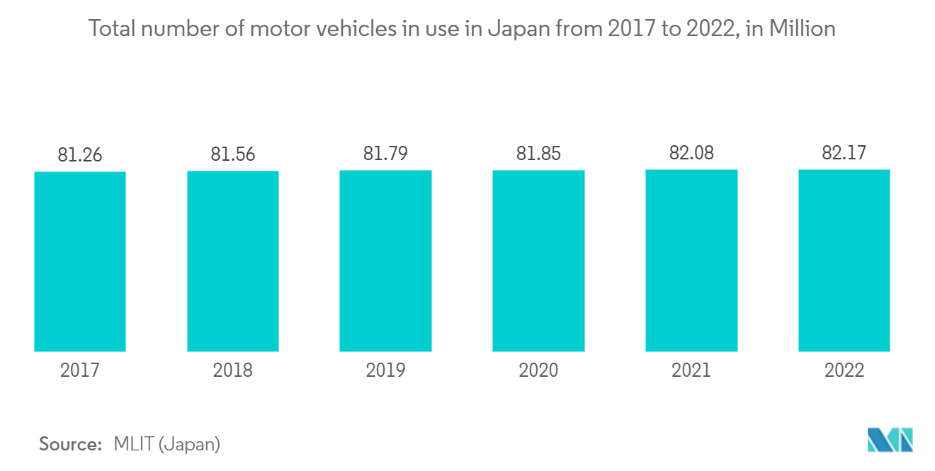
- The below graph shows the increasing number of vehicles in Japan, boosting the infrastructural growth in the country,
Understand The Key Trends Shaping This Market
Download Sample
Growing Use of Satellite Imagery Services in Surveillance and Security
- Using satellite imagery services for surveillance and security witnessed significant growth in Japan. The country has embraced these services to enhance its capabilities in monitoring and safeguarding its border. Satellite imagery offers multiple advantages, such as providing real-time and high-resolution visual data that can be utilized for a wide range of applications, including disaster management, border security, urban planning, and environmental monitoring.
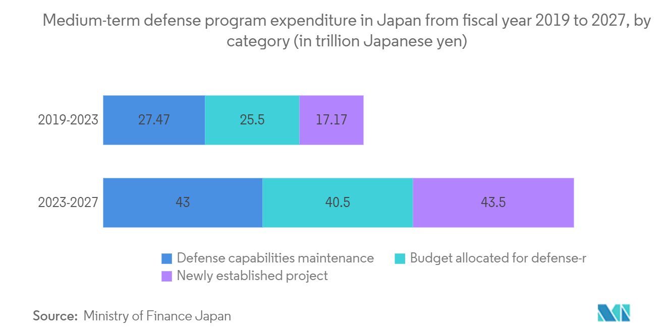
- Japanese government in the country is continiously increasing its security and defense budget to implement new technologies. For instance, in December 2022, the Japanese cabinet announced its 2023 budget of around USD 52 million for the Japanese Self-Defense Forces (JSDF). The new budget is 26 percent higher than the JSDF budget for 2022. The 2023 budget is the first under Japan's new National Security Strategy (NSS).
- Moreover, as an island nation, Japan heavily relies on maritime security to protect its territorial waters and exclusive economic zone. Satellite imagery allows for continuous monitoring of coastlines, detection of illegal fishing activities, and identification of suspicious vessels, thereby strengthening border control and ensuring the safety of its waters.
- Also, for the better survelence system, in January 2023, Japan launched government intelligence-gathering satellite. this satellite will provide the data about the military sites in North Korea and will improve natural disaster response. This satellite will capture images on the ground 24 hours a day and even in severe weather conditions.