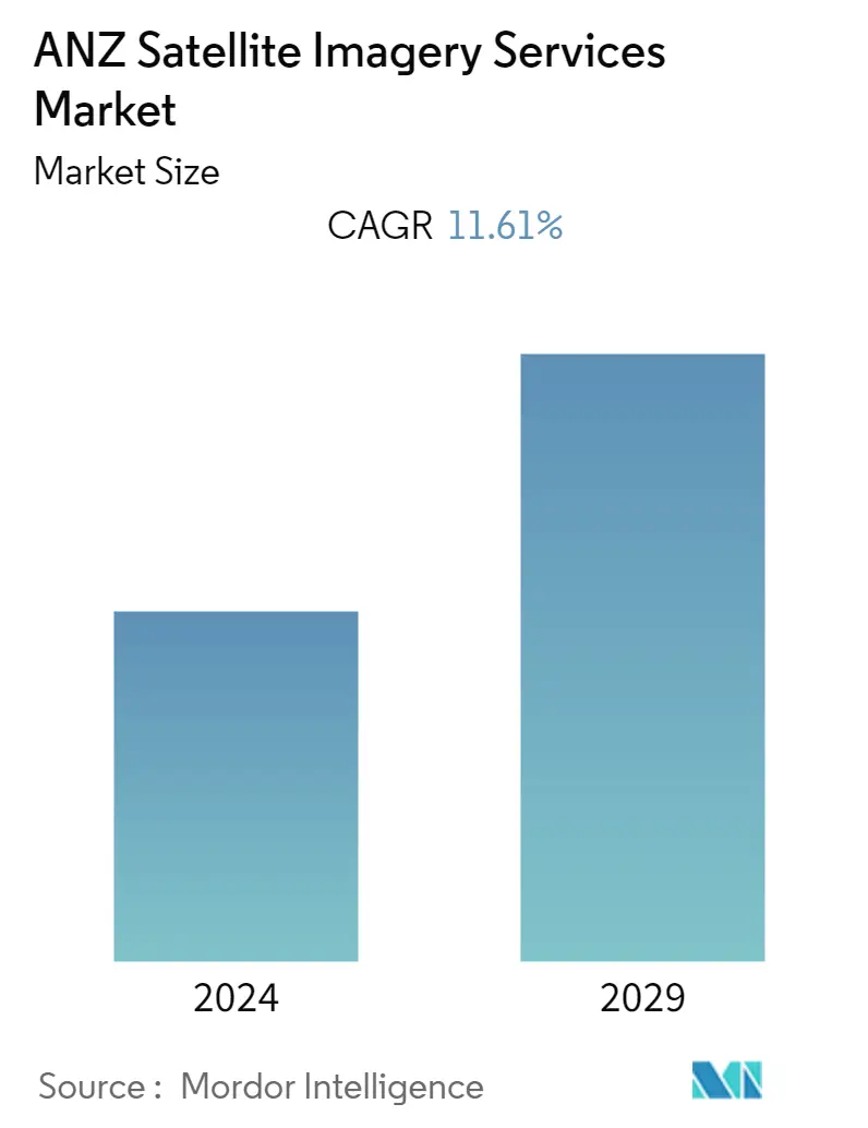
Market Size of ANZ Satellite Imagery Services Industry
| Study Period | 2019 - 2029 |
| Base Year For Estimation | 2023 |
| Forecast Data Period | 2024 - 2029 |
| Historical Data Period | 2019 - 2022 |
| CAGR | 11.61 % |
| Market Concentration | Low |
Major Players
*Disclaimer: Major Players sorted in no particular order |
Need a report that reflects how COVID-19 has impacted this market and its growth?
ANZ Satellite Imagery Services Market Analysis
ANZ's satellite imagery services market is valued at USD 0.12 billion in the current year. It is expected to register a CAGR of 11.61% during the forecast period to reach USD 0.21 billion by the next five years. With growing environmental consciousness, there is an increasing need to monitor environmental changes and address climate change impacts. Satellite imagery services will be crucial in tracking deforestation, land degradation, pollution, and other ecological changes.
- The market size of ANZ satellite imagery services has witnessed significant expansion in recent years, driven by technological advancements, increasing demand for geospatial information, and expanding application areas. Government initiatives in Australia and New Zealand have played a crucial role in fostering market growth, with support for open data policies and geospatial infrastructure development.
- The growing use of satellite imagery in agriculture for crop monitoring and precision farming has been instrumental in driving the market forward. Additionally, the mining sector utilizes satellite imagery for exploration and monitoring activities. Urban planning and environmental monitoring have also been prominent market growth drivers.
- Technological advancements in satellite technology, such as improved spectral capabilities and reduced data acquisition costs, have made satellite imagery services more accessible to various industries and government agencies. Moreover, the rising focus on climate change and environmental sustainability has further propelled the demand for satellite imagery in monitoring ecosystems and natural disasters.
- Despite the market growth, satellite imagery data acquisition and processing costs can be relatively high, particularly for high-resolution and specialized datasets. This can deter small and medium-sized enterprises (SMEs) and certain industries from accessing and utilizing satellite imagery services.
- Further, the COVID-19 pandemic had a mixed impact on the ANZ Satellite Imagery Services Market. While it brought challenges, such as an economic slowdown, delayed projects, and disrupted supply chains, it also presented growth opportunities. The demand for remote monitoring, disaster response, and precision agriculture increased, highlighting the importance of satellite imagery services in critical applications.
