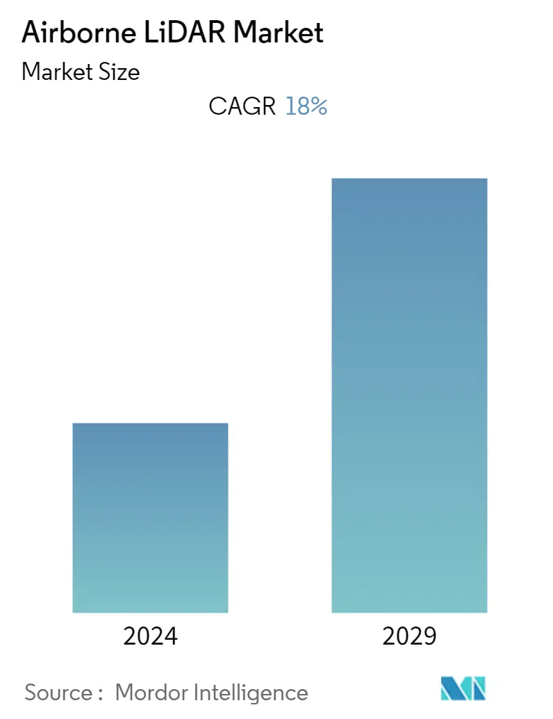
Market Size of Airborne LiDAR Industry
| Study Period | 2019 - 2029 |
| Base Year For Estimation | 2023 |
| CAGR | 18.00 % |
| Fastest Growing Market | North America |
| Largest Market | Asia Pacific |
| Market Concentration | High |
Major Players
*Disclaimer: Major Players sorted in no particular order |
Need a report that reflects how COVID-19 has impacted this market and its growth?
Airborne LiDAR Market Analysis
The airborne lidar market is expected to register a CAGR of 18% over the forecast period. Further, the increased demand for terrain mapping and imagery across industries has resulted in the rapid growth of the demand-based LiDAR service industry. However, enormous opportunities in GIS applications will boost the market growth.
- The combination of LiDAR scanning technology with an aerial deployment platform has enabled the user to extract extraordinary efficiency and speed for gathering accurate spatial data allowing him to support asset management needs for numerous industries such as Aerospace & Defense, Mining, Forestry & Precision Agriculture, Corridor mapping, oil & Gas.
- Surveying And Mapping LLC., with the addition of the state-of-the-art Trimble Harrier 68i airborne LiDAR system to SAM's in-house capabilities. These systems in combination with the three different modes of laser data collection, have enabled the company to enhance its ability to provide complete geospatial solutions and a full suite of LiDAR services.
- The evolution of drones further displays huge potential as aerial photos provide a much bigger perspective when it comes to tracking progress, inspecting the equipment, and measuring structures. Also, the increased usage of airborne lidars in construction projects is expected to drive market growth over the forecast period.
- Further, companies across various end-user industries are adopting airborne lidars rapidly, to enhance their capability and operational efficiency for forestry, rail, electrical utilities, and other high-density applications. For example, during the early onset of the pandemic, Atlantic used Teledyne Optech'snew Galaxy T2000 and G2 sensor system to enhance its airborne capability by accommodating two of the company's OptechGalaxy Prime airborne lidar sensors.
- In November 2021, Hexagon's Geosystems announced partnerships with Airbus to integrate two Leica Chiroptera 4X bathymetric LiDAR sensors for maritime surveillance into the C295 MSA, Airbus' Maritime Surveillance Aircraft. The technology has an object detection feature that enables real-time LiDAR data visualization and analysis during the flight
- Moreover, maintaining a high level of detail and accuracy, the airborne lidars can even scan buildings or an entire city in 3D. These lidars' ability to generate the exact replicas of such locations helps to reduce the time and cost of 3D modeling and assists in creating more realistic visual effects. This further stimulates various companies to provide solutions for the media and entertainment industry.
