Market Size of Commercial Satellite Imaging Industry
| Study Period | 2019 - 2029 |
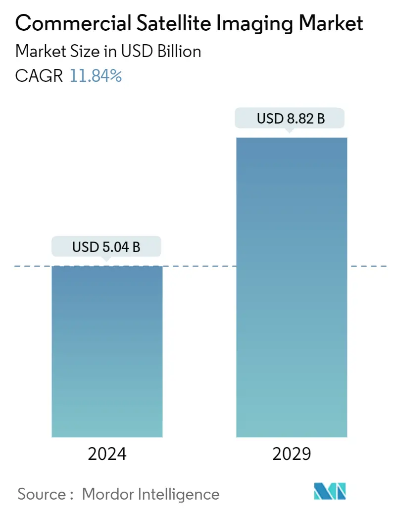
| Market Size (2024) | USD 5.04 Billion |
| Market Size (2029) | USD 8.82 Billion |
| CAGR (2024 - 2029) | 11.84 % |
| Fastest Growing Market | Asia-Pacific |
| Largest Market | North America |
Major Players*Disclaimer: Major Players sorted in no particular order |
Need a report that reflects how COVID-19 has impacted this market and its growth?
Commercial Satellite Imaging Market Analysis
The Commercial Satellite Imaging Market size is estimated at USD 5.04 billion in 2024, and is expected to reach USD 8.82 billion by 2029, growing at a CAGR of 11.84% during the forecast period (2024-2029).
Images of the Earth taken by imaging satellites run by governments and companies worldwide are known as satellite images, sometimes known as Earth observation imagery, spaceborne photography, or simply satellite photos. Meteorology, oceanography, fisheries, agriculture, biodiversity protection, forestry, landscape, geology, cartography, regional planning, education, intelligence, and warfare are just a few fields where satellite photos are used.
- The imaging method generates raw image data using optically equipped satellites. Since it is closer to the object, aeronautical imaging delivers a higher image resolution than satellite imaging. The most economical and greatest image resolution is provided by terrestrial imaging; however, it has geographical limitations. Because of their quick supply of image data and wide coverage, satellites are favored over other imaging techniques. Additionally, imaging services are economical once they are in orbit, supporting industry growth over time.
- The increasing requirement for efficient monitoring of vast land areas is one of the key drivers for the commercial satellite market. The use of satellite imagery and data can provide detailed and accurate information about land use, vegetation, and other features, which can be used for a wide range of applications such as agriculture, urban planning, natural resource management, and environmental monitoring.
- The rising smart city initiatives are also driving the commercial satellite market. Smart cities utilize various technologies, such as the Internet of Things (IoT) and satellite imagery, to collect and analyze data to improve citizens' quality of life and decrease the environmental impact of urban areas. Satellite imagery plays a key role in smart city initiatives by providing detailed and accurate information about the built environment, such as the location and condition of buildings, roads, and other infrastructure. This information can improve urban planning, transportation, and public services.
- Furthermore, several leading players are focusing on investing in satellite imaging technology to stay ahead of the competition. For instance, in August 2022, Accenture announced to make a strategic investment in Pixxel to monitor Earth's health. Pixxel is building the world's highest-resolution hyperspectral imaging satellite constellation to provide industry AI-powered observations that discover, solve, and predict climate issues at a fraction of the cost of traditional satellites.
- Similarly, in April 2022, Pixxel launched India's first private commercial imaging satellite, "Shakuntala," as a part of its planned 36-satellite constellation aboard a SpaceX Falcon-9 rideshare mission.
- The availability of open-source data for various countries can challenge the commercial satellite imaging market. Open-source data refers to satellite imagery and other freely available data to the public, often provided by government agencies or organizations.
- In the post-COVID-19 market, businesses and government organizations are preparing for an innovation shift since the restrictions are lifted to evaluate and modify their supply chains quickly. For instance, in May 2022, the European Space Agency (ESA), Japan Aerospace Exploration Agency (JAXA), and the National Aeronautics and Space Administration (NASA), an independent agency of the U.S. Federal Government that is in charge of the civilian space program as well as aeronautics and space research, announced that they had teamed up to use the combined scientific power of their earth-observing satellites to document global changes in the environment and human society.
